Tromsøysund
| Tromsøysund herred Tromsøe landdistrikt | ||
|---|---|---|
| Former municipality | ||
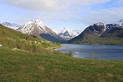 Arm of the Ramfjorden in Tromsøysund | ||
| ||
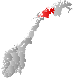
 Tromsøysund within Troms | ||
| Coordinates: 69°38′53″N 18°59′13″E / 69.64806°N 18.98694°ECoordinates: 69°38′53″N 18°59′13″E / 69.64806°N 18.98694°E | ||
| Country | Norway | |
| County | Troms | |
| District | Hålogaland | |
| Established | 1 Jan 1838 | |
| Disestablished | 1 Jan 1964 | |
| Administrative centre | Tromsøysund | |
| Area | ||
| • Total | 1,596 km2 (616 sq mi) | |
| *Area at municipal dissolution. | ||
| Population (1964) | ||
| • Total | 16,727 | |
| • Density | 10/km2 (27/sq mi) | |
| Time zone | UTC+01:00 (CET) | |
| • Summer (DST) | UTC+02:00 (CEST) | |
| ISO 3166 code | NO-1934 | |
| Created as | Formannskapsdistrikt in 1838 | |
| Succeeded by | Tromsø in 1964 | |
Tromsøysund is a former municipality in Troms county in Norway. The 1,596-square-kilometre (616 sq mi) municipality existed from 1838 until its dissolution in 1964. The municipality encompassed most of what is now Tromsø Municipality including areas on the island of Kvaløya and on the mainland. It completely surrounded the city of Tromsø, both on a number of islands as well as on the mainland. The municipality included the villages of Bjerkaker, Tromsdalen, and Movik. The administrative centre was the village of Tromsdalen, just across the strait from the city of Tromsø.[1]
History
The large prestegjeld of Tromsøe existed for hundreds of years. In 1838, the new formannskapsdistrikt law established municipal self-government in Norway. According to the law, each prestegjeld became a municipality, but all cities in Norway had to be separated from their prestegjeld and be their own municipalities. So, on 1 January 1838, the city of Tromsøe became a municipality and the large surrounding district became the municipality of Tromsøe landdistrikt. Initially, the new municipality had a population of 4,286.[2]
In 1860, the southern part of the municipality (population: 3,610) was split off from Tromsøe landdistrikt to become the new Balsfjord Municipality. This left Tromsøe landdistrikt with 2,632 inhabitants. In November 1860, the name of the municipality was changed to Tromsøsundet (the spelling was changed to the more modern spelling Tromsøysund later). On 1 January 1861, an area of Tromsøysund (population: 110) was transferred to the city of Tromsø. On 1 January 1873, a part of the neighboring municipality of Malangen (population: 287) was merged back into Tromsøysund (this area in Malangen was separated from Balsfjord in 1871). This area included the Bakkejord-Kvalnes-Lauksletta-Mjelde area in southern Kvaløya and Brokskar-Bentsjorda area on the mainland. At the same time, an uninhabited part of Tromsøysund was also transferred to Tromsø. On 1 July 1915, another part of Tromsøysund (population: 512) was transferred to the city of Tromsø. Again on 1 July 1955, the Bjerkaker area of Tromsøysund (population: 1,583) was transferred to the city of Tromsø.
During the 1960s, there were many municipal mergers across Norway due to the work of the Schei Committee. On 1 January 1964, a major municipal merger took place. All of Tromsøysund municipality (population: 16,727) was merged with the city of Tromsø (population: 12,602), the parts of Hillesøy municipality on Kvaløya island (population: 1,316), and most (except the Svensby area) of Ullsfjord municipality (population: 2,019) to form a new, larger Tromsø Municipality.[1][3][4]
See also
References
- 1 2 Thorsnæs, Geir, ed. (2018-04-09). "Tromsøysund – tidligere kommune". Store norske leksikon (in Norwegian). Kunnskapsforlaget. Retrieved 2018-08-01.
- ↑ Registreringssentral for historiske data. "Hjemmehørende folkemengde Troms 1801-1960" (in Norwegian). University of Tromsø.
- ↑ Jukvam, Dag (1999). "Historisk oversikt over endringer i kommune- og fylkesinndelingen" (PDF) (in Norwegian). Statistisk sentralbyrå.
- ↑ "Arkivkatalog. Tromsøysund kommune. 1838–1963" (PDF) (in Norwegian). Tromsø kommune. Retrieved 2012-12-12.
External links

| |||||||||
| |||||||||
| |||||||||