Silsand
| Silsand | |
|---|---|
| Village | |
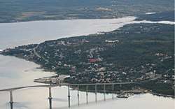 View of Silsand with the bridge to Finnsnes | |
 Silsand Location in Troms  Silsand Silsand (Norway) | |
| Coordinates: 69°14′19″N 17°56′20″E / 69.23861°N 17.93889°ECoordinates: 69°14′19″N 17°56′20″E / 69.23861°N 17.93889°E | |
| Country | Norway |
| Region | Northern Norway |
| County | Troms |
| District | Midt-Troms |
| Municipality | Lenvik Municipality |
| Area[1] | |
| • Total | 1.03 km2 (0.40 sq mi) |
| Elevation[2] | 12 m (39 ft) |
| Population (2017)[1] | |
| • Total | 1,583 |
| • Density | 1,537/km2 (3,980/sq mi) |
| Time zone | UTC+01:00 (CET) |
| • Summer (DST) | UTC+02:00 (CEST) |
| Post Code | 9303 Silsand |
Silsand is a village in Lenvik Municipality in Troms county, Norway. It is located on the eastern shore of the large island of Senja. The 1.03-square-kilometre (250-acre) village has a population (2017) of 1,583 which gives the village a population density of 1,537 inhabitants per square kilometre (3,980/sq mi).[1]
Silsand is now considered a suburb of the neighboring town of Finnsnes, which is located across the Gisundet strait on the mainland. Before the construction of the Gisund Bridge, Silsand consisted of just a few houses. With the construction of the bridge and the change in rural Norwegian demographics, the population has experienced a rapid increase since the early 1980s. Most of the new inhabitants come from other smaller villages in the Midt-Troms area.
Silsand has three schools: Småslettan skole (1-4th grade), Silsand barneskole (5-7th grade) and Silsand ungdomsskole (8-10th grade). FK Senja, a football club, is also based in Silsand, with their home field in the neighboring village of Laukhella. Storevatnet lake is located just northwest of the town.
References
- 1 2 3 Statistisk sentralbyrå (1 January 2017). "Urban settlements. Population and area, by municipality".
- ↑ "Silsand, Lenvik" (in Norwegian). yr.no. Retrieved 2012-12-07.