Bjarkøy
| Bjarkøy kommune Bjarkedjo suohkan | |||
|---|---|---|---|
| Former municipality | |||
| |||
 Bjarkøy within Troms | |||
| Coordinates: 68°59′55″N 16°29′53″E / 68.99861°N 16.49806°ECoordinates: 68°59′55″N 16°29′53″E / 68.99861°N 16.49806°E | |||
| Country | Norway | ||
| County | Troms | ||
| District | Central Hålogaland | ||
| Established | 1 Jan 1838 | ||
| Disestablished | 1 Jan 2013 | ||
| Administrative centre | Nergården | ||
| Area | |||
| • Total | 73.61 km2 (28.42 sq mi) | ||
| • Land | 73.44 km2 (28.36 sq mi) | ||
| • Water | 0.17 km2 (0.07 sq mi) 0.2% | ||
| *Area at municipal dissolution. | |||
| Population (2013) | |||
| • Total | 455 | ||
| • Density | 6.2/km2 (16/sq mi) | ||
| Demonym(s) | Bjarkøyværing[1] | ||
| Time zone | UTC+01:00 (CET) | ||
| • Summer (DST) | UTC+02:00 (CEST) | ||
| ISO 3166 code | NO-1915 | ||
| Official language form | Neutral | ||
| Created as | Formannskapsdistrikt in 1838 | ||
| Succeeded by | Harstad in 2013 | ||

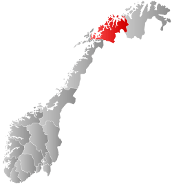
Bjarkøy is a former municipality in Troms county, Norway. The 73.6-square-kilometre (28.4 sq mi) municipality existed from 1838 until it was merged with Harstad Municipality on 1 January 2013. The administrative centre of the municipality was the village of Nergården on the island of Bjarkøya. The island municipality was spread across several islands: Bjarkøya, Sandsøya, Grytøya (northern half), Krøttøya, and many smaller ones. Originally, the municipality also included the southwestern part of the large island of Senja.
One of the reasons why Bjarkøy merged with Harstad in 2013 was due to the promised funding of the Bjarkøy Fixed Link project. It would link the main islands of Bjarkøy together with a bridge and undersea road tunnel enabling residents to drive further which would drastically shorten the ferry ride to Harstad.
General information

The prestegjeld (church parish) of Sand was established as a municipality on 1 January 1838 (see formannskapsdistrikt). The name was later changed to Bjarkøy. During the 1960s, there were many municipal mergers across Norway due to the work of the Schei Committee. On 1 January 1964, the southernmost part of the island of Senja (the Senjehesten peninsula) and the Lemmingsvær island (total population of the two locations: 480) was transferred from Bjarkøy to Tranøy Municipality.[2] On 1 January 2013, Bjarkøy Municipality was merged with Harstad Municipality to the south, forming a new, larger municipality called Harstad.
Name
The municipality was named after the island of Bjarkøya (Old Norse: Bjarkarey). The first element is the genitive case of bjørk which means "birch" and the last element is øy which means "island". (The name of the island, since it is an old trading place, is perhaps inspired by the name of the old and well-known town of Birka in Sweden, which has the same meaning).[3][4]
Prior to 1887, the municipality was called Sand after the name of the church site on the nearby island of Sandsøya. In 1887, the church was moved to the island of Bjarkøya, so the municipal name was changed to Bjarkø (an older spelling). More recent spelling reforms have it spelled Bjarkøy.
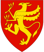
Coat of arms
The coat of arms were from modern times; they were granted on 11 April 1986. The arms showed a golden griffin on a blue background. They were derived from the arms of the Bjarkøy dynasty, one of the most influential families in the northern part of Norway. The griffin was already used in the seal and arms of the family in the late 13th century.[5] The arms of Bjarkøy were retired after the merger in 2013 since Harstad retained its old coat of arms after the merger.[6]
Churches
The Church of Norway had one parish (sokn) within the municipality of Bjarkøy. It was part of the Trondenes prosti (deanery) in the Diocese of Nord-Hålogaland.
| Parish (Sokn) | Church Name | Location of the Church | Year Built |
|---|---|---|---|
| Bjarkøy og Sandsøy | Bjarkøy Church | Nergården | 1766 |
| Sandsøy Church | Sandsøya | 1888 |
History
This is old Viking territory, and it was a chieftain seat during the Viking Age and the Middle Ages. Among the more famous chieftains you find Thorir Hund, who killed Norway's Patron Saint, Saint Olav in the Battle of Stiklestad in 1030. In 1323, the chieftain seat was raided and burned by Karelian warriors.
Geography
The municipality of Bjarkøy was located entirely on islands. The largest island, Grytøya, was shared with the municipality of Harstad. Other islands included Bjarkøya, Sandsøya, Helløya, Flatøya, and Meløyvær. The Andfjorden flowed along the northern and western side of the municipality and the Vågsfjorden flowed on the eastern and southern sides of the municipality.
Climate
| Climate data for Bjarkøya | |||||||||||||
|---|---|---|---|---|---|---|---|---|---|---|---|---|---|
| Month | Jan | Feb | Mar | Apr | May | Jun | Jul | Aug | Sep | Oct | Nov | Dec | Year |
| Daily mean °C (°F) | −2.4 (27.7) |
−2.4 (27.7) |
−1.3 (29.7) |
1.4 (34.5) |
5.7 (42.3) |
9.3 (48.7) |
11.8 (53.2) |
11.5 (52.7) |
7.9 (46.2) |
4.2 (39.6) |
0.7 (33.3) |
−1.5 (29.3) |
3.7 (38.7) |
| Average precipitation mm (inches) | 93 (3.66) |
79 (3.11) |
68 (2.68) |
54 (2.13) |
41 (1.61) |
45 (1.77) |
73 (2.87) |
69 (2.72) |
88 (3.46) |
118 (4.65) |
90 (3.54) |
107 (4.21) |
925 (36.42) |
| Source: Norwegian Meteorological Institute[7] | |||||||||||||
Media gallery
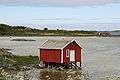 Boathouse located on Krøttøy
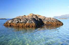 Skerry in shallow water, located just outside Krøttøy
 Map of Bjarkøy
References
- ↑ "Navn på steder og personer: Innbyggjarnamn" (in Norwegian). Språkrådet. Retrieved 2015-12-01.
- ↑ Jukvam, Dag (1999). "Historisk oversikt over endringer i kommune- og fylkesinndelingen" (PDF) (in Norwegian). Statistisk sentralbyrå.
- ↑ Rygh, Oluf (1911). Norske gaardnavne: Troms amt (in Norwegian) (17 ed.). Kristiania, Norge: W. C. Fabritius & sønners bogtrikkeri. p. 30.
- ↑ Thorsnæs, Geir, ed. (2018-02-14). "Bjarkøy". Store norske leksikon (in Norwegian). Kunnskapsforlaget. Retrieved 2018-07-29.
- ↑ "Civic heraldry of Norway - Norske Kommunevåpen". Heraldry of the World. Retrieved 2018-07-29.
- ↑ Tøhaug, Pia (2013-02-01). "Harstad beholder bølgesymbolet". NRK Troms (in Norwegian). Retrieved 2018-07-29.
- ↑ "eKlima Web Portal". Norwegian Meteorological Institute. Archived from the original on 2004-06-14.
External links


- Municipal fact sheet from Statistics Norway
| |||||||||
| |||||||||
| |||||||||