Øverbygd
| Øverbygd herred | ||
|---|---|---|
| Former municipality | ||
 View of the Øvre Dividal park in Øverbygd | ||
| ||
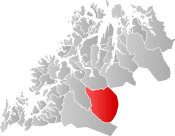 Øverbygd within Troms | ||
| Coordinates: 69°01′27″N 19°17′45″E / 69.02417°N 19.29583°ECoordinates: 69°01′27″N 19°17′45″E / 69.02417°N 19.29583°E | ||
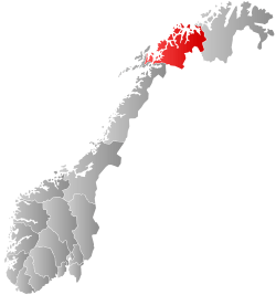
| Country | Norway | |
| County | Troms | |
| District | Hålogaland | |
| Established | 1 July 1925 | |
| Disestablished | 1 Jan 1964 | |
| Administrative centre | Skjold | |
| Area | ||
| • Total | 2,132 km2 (823 sq mi) | |
| *Area at municipal dissolution. | ||
| Population (1964) | ||
| • Total | 1,232 | |
| • Density | 0.58/km2 (1.5/sq mi) | |
| Demonym(s) | Øverbygding[1] | |
| Time zone | UTC+01:00 (CET) | |
| • Summer (DST) | UTC+02:00 (CEST) | |
| ISO 3166 code | NO-1923 | |
| Preceded by | Målselv in 1925 | |
| Succeeded by | Målselv in 1964 | |
Øverbygd is a former municipality in Troms county in Norway. The 2,152-square-kilometre (831 sq mi) municipality existed from 1925 until its dissolution in 1964. It was located in what is now the eastern part of Målselv Municipality, stretching from the border with Sweden in the east, through the Dividalen and Rostadalen valleys to the Målselva river and the eastern part of the Målselvdalen valley. The administrative centre was the village of Skjold. Skjold was the site of the local church, Øverbygd Church as well as home to a large garrison for the Norwegian Army. Øvre Dividal National Park made up a large part of the southeastern part of the municipality.[2]
History
The municipality of Øverbygd was established on 1 July 1925 when Målselv Municipality was divided into two municipalities: Målselv in the west and Øverbygd in the east. Initially, Øverbygd had a population of 566 inhabitants.
During the 1960s, there were many municipal mergers across Norway due to the work of the Schei Committee. On 1 January 1964, Øverbygd municipality (population: 1,232) was merged with all of the municipality of Målselv (population: 5,584), the Naveren and Målsnes areas of Malangen municipality (population: 118), and the Skogli ved Heia farm (population: 2) from Balsfjord municipality to form a new, larger Målselv Municipality.[2][3]
World War II
During World War II, the German army created a military base at Øverbygd. The base was initially a supply point for the German forces attack on Murmansk. German soldiers on retreat at the end of the war came through Øverbygd. Maukstadmoen and Holmen were undeveloped pine forests, but virtually all of the commercial forest was cut down to provide German troops land and building materials.
Large barracks for the officer's quarters were established on Maukstadmoen. They also built large stock barracks, a cold storage plant, and a German military hospital. A Prisoner-of-war camp for Russian prisoners of war and medical camp was built near Holmen.
References
- ↑ "Navn på steder og personer: Innbyggjarnamn" (in Norwegian). Språkrådet. Retrieved 2015-12-01.
- 1 2 Thorsnæs, Geir, ed. (2018-06-18). "Øverbygd – tidligere kommune". Store norske leksikon (in Norwegian). Kunnskapsforlaget. Retrieved 2018-08-01.
- ↑ Jukvam, Dag (1999). "Historisk oversikt over endringer i kommune- og fylkesinndelingen" (PDF) (in Norwegian). Statistisk sentralbyrå.
External links

| |||||||||
| |||||||||
| |||||||||