Berg, Norway
| Berg kommune Birgi suohkan | |||
|---|---|---|---|
| Municipality | |||
 | |||
| |||
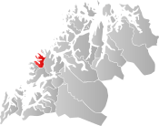 Berg within Troms | |||
| Coordinates: 69°28′00″N 17°23′52″E / 69.46667°N 17.39778°ECoordinates: 69°28′00″N 17°23′52″E / 69.46667°N 17.39778°E | |||
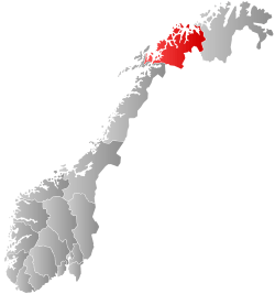
| Country | Norway | ||
| County | Troms | ||
| District | Midt-Troms | ||
| Established | 1 Jan 1838 | ||
| Administrative centre | Skaland | ||
| Government | |||
| • Mayor (2015) | Roar Jakobsen (Local list) | ||
| Area | |||
| • Total | 293.89 km2 (113.47 sq mi) | ||
| • Land | 276.34 km2 (106.70 sq mi) | ||
| • Water | 17.55 km2 (6.78 sq mi) 6% | ||
| Area rank | #281 in Norway | ||
| Population (2017) | |||
| • Total | 914 | ||
| • Rank | #406 in Norway | ||
| • Density | 3.3/km2 (9/sq mi) | ||
| • Change (10 years) | -5% | ||
| Demonym(s) | Bergsværing[1] | ||
| Time zone | UTC+01:00 (CET) | ||
| • Summer (DST) | UTC+02:00 (CEST) | ||
| ISO 3166 code | NO-1929 | ||
| Official language form | Bokmål | ||
| Website |
berg | ||

Berg is a municipality in Troms county, Norway. The administrative centre of the municipality is the village of Skaland. Other villages include Finnsæter, Mefjordvær, and Senjahopen. The municipality is located on the western part of the large island of Senja.
The 294-square-kilometre (114 sq mi) municipality is the 281st largest by area out of the 422 municipalities in Norway. Berg is the 406th most populous municipality in Norway with a population of 914. The municipality's population density is 3.3 inhabitants per square kilometre (8.5/sq mi) and its population has decreased by 5% over the last decade.[2]
The municipality was the first place in the world to utilize a hydroelectrical power station in the mining community of Hamn. When the mining industry ceased, the "electrical adventure" did as well. The buildings are still located at Hamn, now functioning as a special hotel/lodge.
The first female pastor in the Lutheran Church of Norway, Ingrid Bjerkås, worked in this parish, starting in 1961.
General information

Berg was established as a municipality on 1 January 1838 (see formannskapsdistrikt). The southern part of Berg (population: 1,229) was separated from Berg to form the new Torsken Municipality on 1 January 1902. This left Berg with 1,002 residents. The municipal borders have not changed since.[3]
In March 2017, the Parliament of Norway voted to merge the municipalities of Berg, Torsken, Lenvik, and Tranøy. The new municipality will encompass the whole island of Senja plus part of the mainland. The new Senja Municipality will be established on 1 January 2020.[4][5]
Name
The municipality (originally the parish) is named after the old Berg farm (Old Norse: Bærg) in what is now the village of Skaland. The farm is where Berg Church is located. The name is identical with the word berg which means "mountain".[6]
Coat of arms
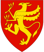
The coat of arms is from modern times; they were granted on 2 October 1987. The gray/white and black arms are canting since "berg" means "mountain" in Norwegian and the arms show the profile of the three mountains of Trælen, Oksen, and Kjølva. The colors represent "winter darkness", "black sea", and "toward brighter times."[7][8]
Churches
The Church of Norway has one parish (sokn) within the municipality of Berg. It is part of the Senja prosti (deanery) in the Diocese of Nord-Hålogaland.
| Parish (Sokn) | Church Name | Location of the Church | Year Built |
|---|---|---|---|
| Berg | Berg Church | Skaland | 1955 |
| Finnsæter Chapel | Finnsæter | 1982 | |
| Mefjordvær Chapel | Mefjordvær | 1916 |
Geography

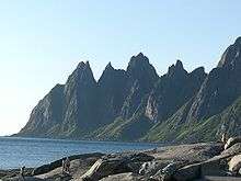
The municipality faces the Atlantic Ocean on the west side of the large island of Senja. The largest urban area in Berg is the village of Senjahopen. The highest point on the island, the mountain Breidtinden, is located in the northeastern part of Berg. There are three large fjords that cut into the municipality: Bergsfjorden, Ersfjorden, and Mefjorden.
Climate
| Climate data for Skaland, Berg | |||||||||||||
|---|---|---|---|---|---|---|---|---|---|---|---|---|---|
| Month | Jan | Feb | Mar | Apr | May | Jun | Jul | Aug | Sep | Oct | Nov | Dec | Year |
| Daily mean °C (°F) | −2.5 (27.5) |
−2.5 (27.5) |
−1.4 (29.5) |
1.2 (34.2) |
5.3 (41.5) |
8.8 (47.8) |
11.3 (52.3) |
11.1 (52) |
7.8 (46) |
4.1 (39.4) |
0.6 (33.1) |
−1.6 (29.1) |
3.5 (38.3) |
| Average precipitation mm (inches) | 109 (4.29) |
94 (3.7) |
88 (3.46) |
77 (3.03) |
55 (2.17) |
67 (2.64) |
77 (3.03) |
91 (3.58) |
115 (4.53) |
152 (5.98) |
129 (5.08) |
131 (5.16) |
1,185 (46.65) |
| Source: Norwegian Meteorological Institute[9] | |||||||||||||
Government
All municipalities in Norway, including Berg, are responsible for primary education (through 10th grade), outpatient health services, senior citizen services, unemployment and other social services, zoning, economic development, and municipal roads. The municipality is governed by a municipal council of elected representatives, which in turn elect a mayor.[10] The municipality falls under the Senja District Court and the Hålogaland Court of Appeal.
Municipal council
The municipal council (Kommunestyre) of Berg is made up of 15 representatives that are elected to four year terms. Currently, the party breakdown is as follows:[11]
| Party Name | Name in Norwegian | Number of representatives | |
|---|---|---|---|
| Labour Party | Arbeiderpartiet | 6 | |
| Progress Party | Fremskrittspartiet | 1 | |
| Local Lists | Lokale lister | 8 | |
| Total number of members: | 15 | ||
References
- ↑ "Navn på steder og personer: Innbyggjarnamn" (in Norwegian). Språkrådet. Retrieved 2015-12-01.
- ↑ Statistisk sentralbyrå (2017). "Table: 06913: Population 1 January and population changes during the calendar year (M)" (in Norwegian). Retrieved 2017-09-09.
- ↑ Jukvam, Dag (1999). "Historisk oversikt over endringer i kommune- og fylkesinndelingen" (PDF) (in Norwegian). Statistisk sentralbyrå.
- ↑ "Senja kommune 2020" (in Norwegian). Retrieved 2017-09-09.
- ↑ Vermes, Thomas (2017-03-29). "Stortingsflertallet gjør fire Senja-kommuner til én". ABC Nyheter (in Norwegian). Retrieved 2017-09-09.
- ↑ Rygh, Oluf (1911). Norske gaardnavne: Troms amt (in Norwegian) (17 ed.). Kristiania, Norge: W. C. Fabritius & sønners bogtrikkeri. pp. 72–73.
- ↑ "Beskrivelse av kommunevåpenet" (in Norwegian). Retrieved 2008-12-01.
- ↑ "Civic heraldry of Norway - Norske Kommunevåpen". Heraldry of the World. Retrieved 2017-09-07.
- ↑ "eKlima Web Portal". Norwegian Meteorological Institute. Archived from the original on 2004-06-14.
- ↑ Hansen, Tore, ed. (2016-05-12). "kommunestyre". Store norske leksikon (in Norwegian). Kunnskapsforlaget. Retrieved 2018-08-23.
- ↑ "Table: 04813: Members of the local councils, by party/electoral list at the Municipal Council election (M)" (in Norwegian). Statistics Norway.
External links
| Wikimedia Commons has media related to Berg (Senja). |
| Look up Berg in Wiktionary, the free dictionary. |

- Municipal fact sheet from Statistics Norway (in Norwegian)
| |||||||||
| |||||||||
| |||||||||
| Authority control |
|---|