Lac La Biche, Alberta
| Lac La Biche | |
|---|---|
| Hamlet | |
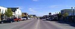 Main street | |
| Motto(s): Forestry Capital of Canada | |
 Lac La Biche Location of Lac La Biche in Alberta | |
| Coordinates: 54°46′13″N 111°58′45″W / 54.77028°N 111.97917°WCoordinates: 54°46′13″N 111°58′45″W / 54.77028°N 111.97917°W | |
| Country |
|
| Province |
|
| Region | Northern Alberta |
| Census division | 12 |
| Municipal district | Lac La Biche County |
| Founded | October 4, 1798 |
| Dissolved | August 1, 2007[1] |
| Government | |
| • Mayor | Omer Moghrabi |
| • Governing body |
Lac La Biche County Council
|
| Area (2011)[2] | |
| • Total | 6.20 km2 (2.39 sq mi) |
| Elevation[3] | 560 m (1,840 ft) |
| Population (2011)[4][2] | |
| • Total | 2,520 |
| • Density | 407.8/km2 (1,056/sq mi) |
| • Population centre | 2,544 |
| • Population centre density | 410.6/km2 (1,063/sq mi) |
| Time zone | UTC−7 (MST) |
| • Summer (DST) | UTC−6 (MDT) |
| Postal code span | T0A 2C0-T0A 2C2 & T0A 3Z0 |
| Area code(s) | -1+780 |
| Highways |
Highway 55 Highway 36 Highway 881 |
| Waterway | Lac la Biche |
| Website | laclabichecounty.com |
| Official name | Notre Dame des Victoires / Lac La Biche Mission National Historic Site of Canada |
| Designated | 1989 |
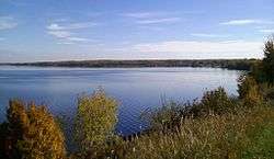
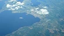
Lac La Biche is a hamlet in Alberta, Canada, within Lac La Biche County.[5] It is located approximately 220 kilometres (140 mi) northeast of the provincial capital of Edmonton, on the southern shore of Lac la Biche. Previously incorporated as a town, Lac La Biche amalgamated with Lakeland County to form Lac La Biche County on August 1, 2007.[1]
History
Etymology
The indigenous peoples of the area referred to the lake as Elk Lake (Nêhiyawêwin: wâwâskesiwisâkahikan,[6] Dënesųłiné: tzalith tway).[7] The earliest Europeans translated this name into English as "Red Deer Lake" and in French as "Lac la biche". Over time, the French name came to be used in English as well.
Historic voyageur highway
Lac La Biche was on the historical voyageur route that linked the Athabaskan region to Hudson Bay. David Thompson and George Simpson used the fur trade route via the Beaver River from the main Methye Portage route that reached the Athabasca River.[8] David Thompson was the first known European to record his sojourn on Lac La Biche. Thompson, who referred to the lake as Red Deers Lake, arrived October 4, 1798 and built a trading post,[9] now known as Lac La Biche,[10] and overwintered there. He entered copious notes in his diary on the Nahathaway (the Cree), their customs, traditions, and the Western Forest Land, including the large supply of whitefish and beaver.[11]
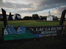
Oblate mission
A Roman Catholic mission was established in 1853 by Oblate missionaries. Historian Paul Robert Magocsi notes how the settlement grew over the next few decades:
"The French-speaking element, mostly from Red River, coalesced around the [Mission]. It formed a community that was tightly knit, even though the influence of the church lessened and the trend was towards marrying out and establishing nuclear families. Living was largely off the land; logging and road work provided intermittent wage labour. Many of the adults were trilingual, speaking French and Cree as well as English."[12]
The Hudson's Bay Post at Lac La Biche was looted on April 26, 1885 during the Northwest Rebellion by members of Big Bear's band. Their plan to loot the nearby Roman Catholic Mission was stopped by the local Cree and Métis population.[13] Métis Scrip Records show many residents of the area were awarded scrip by the Government of Canada from 1885 until the 1920s.[10]
The Lac La Biche Mission is now a National Historic Site and Provincial Historic Resource. It was the site of one of the first residential schools in Alberta.[14][15]
Demographics
Due to the community's unique municipal status, its population can be measured in a number of ways.
As a designated place (hamlet) in the 2016 Census of Population conducted by Statistics Canada, Lac La Biche recorded a population of 2,314 living in 895 of its 1,048 total private dwellings, a change of −8.2% from its 2011 population of 2,520. With a land area of 6.05 km2 (2.34 sq mi), it had a population density of 382.5/km2 (990.6/sq mi) in 2016.[16]
Lac La Biche County's 2016 municipal census counted a population of 2,682 in the urban service area of Lac La Biche,[17] a −7.4% change from the area's2013 municipal census population of 2,895.[18]
In the 2011 Census, the dissolved Town of Lac La Biche had a population of 2,520 living in 929 of its 1,038 total dwellings, a −8.6% change from its 2006 population of 2,758. With a land area of 6.18 km2 (2.39 sq mi), it had a population density of 407.8/km2 (1,056.1/sq mi) in 2011.[4]
As a population centre in the 2011 Census, Lac La Biche had a population of 2,544 living in 938 of its 1,047 total dwellings, a −7.8% change from its 2006 population of 2,758. With a land area of 6.2 km2 (2.4 sq mi), it had a population density of 410/km2 (1,063/sq mi) in 2011.[2]
Economy
The community is supported by the oil patch, logging, forestry, agriculture, and commercial fishing.
Attractions
Lac La Biche is home to the Lac La Biche Golf Course,[19] while numerous lakes and campgrounds provide outdoor recreation opportunities in the area, including Lakeland Provincial Park to the east. Lac La Biche County also houses their local museum in the MacArthur Place Basement.
Government
The Hamlet of Lac La Biche comprises Lac La Biche County's Ward 7.[1] Councillors Hajar Haymour and John Nowak represent Ward 7 on Lac La Biche County Council.[20] Provincially, the community has been represented by every major political party in Alberta history (expand table for details).
Infrastructure
Lac La Biche Airport (YLB) is located 1.5 NM west of Lac La Biche. It features a fully serviced 5,700 ft (1,700 m) by 100 ft (30 m) paved airstrip.
Education
The main campus of Portage College is located in Lac La Biche. The college has an ACAC hockey team named the Portage Voyageurs. The team's first season began in the fall of 2008.[21]
- Northern Lights School Division No. 69
- Vera M. Welsh Elementary School (K-3)
- Aurora Middle School (4–8)
- J.A. Williams High School (9–12)
- Lac La Biche Off-Campus (8–12)
Media
Media outlets serving Lac La Biche and area include the Lac La Biche Post weekly newspaper[22] and the Boom 103.5 radio station.[23]
See also
References
- 1 2 3 Province of Alberta (April 1, 2007). "Order in Council (O.C.) 332-2007". Retrieved March 11, 2010.
- 1 2 3 "Census Profile – Lac La Biche, Alberta (Population centre)". Statistics Canada. February 8, 2012. Retrieved February 8, 2012.
- ↑ "Alberta Private Sewage Systems 2009 Standard of Practice Handbook: Appendix A.3 Alberta Design Data (A.3.A. Alberta Climate Design Data by Town)" (PDF) (PDF). Safety Codes Council. January 2012. pp. 212–215 (PDF pages 226–229). Retrieved October 8, 2013.
- 1 2 "Census Profile – Lac La Biche, Town, Alberta (Dissolved census subdivision)". Statistics Canada. November 2, 2012. Retrieved December 2, 2012.
- ↑ Alberta Municipal Affairs (April 1, 2010). "Specialized and Rural Municipalities and Their Communities" (PDF). Archived from the original (PDF) on February 29, 2012. Retrieved June 28, 2010.
- ↑ "Online Cree Dictionary: ᐋᐧᐋᐧᐢᑫᓯᐃᐧᓵᑲᐦᐃᑲᐣ". Retrieved 2018-09-17.
- ↑ Fromhold, Joachim (2001). 2001 Indian Place Names of the West - Part 1. Calgary: Lulu. pp. CCC. ISBN 9780557438365.
- ↑ "Disclaimer – Electronic Collection". Epe.lac-bac.gc.ca. Retrieved July 30, 2013.
- ↑ Thompson 1916, p. 304.
- 1 2 Barkwell 2013.
- ↑ Thompson 1916, pp. 304–305.
- ↑ Dickason 1999, p. 77.
- ↑ Heather Devine (2004). The People who Own Themselves: Aboriginal Ethnogenesis in a Canadian Family, 1660–1900. University of Calgary Press. p. 162. ISBN 978-1-55238-115-1.
- ↑ Canada's Historic Places. "Notre Dame des Victoires / Lac La Biche Mission National Historic Site". Retrieved 2014-01-19.
- ↑ Lac La Biche Mission. "Lac La Biche Mission national historic site". Retrieved December 25, 2009.
- ↑ "Population and dwelling counts, for Canada, provinces and territories, and designated places, 2016 and 2011 censuses – 100% data (Alberta)". Statistics Canada. February 8, 2017. Retrieved February 13, 2017.
- ↑ "Lac La Biche County 2016 Municipal Census Report". Lac La Biche County. p. 13. Retrieved January 28, 2017.
- ↑ "2013 Census Summary". Lac La Biche County. p. 6. Retrieved January 28, 2017.
- ↑ "Lac La Biche Golf & Country Club". Lac La Biche Golf & Country Club. Retrieved January 28, 2013.
- ↑ "Council". Lac La Biche County. Retrieved July 10, 2013.
- ↑ Voyageur Athletics Archived 2010-03-28 at the Wayback Machine.
- ↑ "Lac La Biche Post". Great West Newspapers LP. Retrieved January 28, 2013.
- ↑ "Boom 103.5 - 80's & 90's". Boom 103.5. Boom 103.5 FM. Retrieved July 21, 2017.
Sources
| Wikivoyage has a travel guide for Lac La Biche. |
- Barkwell, Lawrence J. (2013). Metis scrip claims from Lac la Biche, Alberta under the Dominion Lands Act (Report).
- Dickason, Olive P. (1999). "Metis". In Paul Robert Magocsi. The Encyclopedia of Canada's Peoples. Toronto, Ontario: University of Toronto Press. ISBN 0-8020-2938-8.
- Thompson, David (1916). J. B. Tyrrell, ed. David Thompson's Narrative of his Explorations in Western America 1784–1812. Toronto: Champlain Society. This is the full-text diary of David Thompson which includes numerous references to the Nahathaway in general and to the First Nations of the Lac la Biche region in particular. He describes their belief in life after death and consequences on the human soul for crimes and misdeeds.
Places adjacent to Lac La Biche, Alberta | |
|---|---|
| Provinces | |
|---|---|
| Territories | |
| Other countries | |
| |