Lac des Arcs, Alberta
| Lac des Arcs | |
|---|---|
| Hamlet | |
 | |
 Location of Lac des Arcs in Alberta | |
| Coordinates: 51°03′06″N 115°09′23″W / 51.0517°N 115.1564°W | |
| Country |
|
| Province |
|
| Census division | No. 15 |
| Municipal district | M.D. of Bighorn No. 8 |
| Government | |
| • Type | Unincorporated |
| • Governing body | M.D. of Bighorn No. 8 Council |
| Area[1] | |
| • Total | 0.52 km2 (0.20 sq mi) |
| Elevation | 1,320 m (4,330 ft) |
| Population (2016)[1] | |
| • Total | 130 |
| • Density | 250/km2 (650/sq mi) |
| • Dwellings | 83 |
| Time zone | UTC−7 (MST) |
| • Summer (DST) | UTC−6 (MDT) |
Lac des Arcs is a hamlet in Alberta, Canada within the Municipal District (M.D.) of Bighorn No. 8.[2] It is located on the south side of the Bow River opposite the Hamlet of Exshaw and has an elevation of 1,320 metres (4,330 ft). Highway 1 (the Trans-Canada Highway) borders Lac des Arcs on the south.
The hamlet is located in census division No. 15 and in the federal riding of Wild Rose.
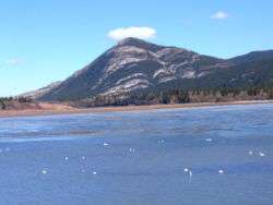
Lake
The wide span of the Bow River adjacent to the Hamlet of Lac des Arcs is also referred to as a lake under the same name, which attracts wind surfers and fishers. The Lafarge Exshaw Plant, a limestone quarry, is developed on the lake's northern shore.
Demographics
As a designated place in the 2016 Census of Population conducted by Statistics Canada, Lac des Arcs recorded a population of 130 living in 53 of its 83 total private dwellings, a change of −9.7% from its 2011 population of 144. With a land area of 0.52 km2 (0.20 sq mi), it had a population density of 250.0/km2 (647.5/sq mi) in 2016.[1]
As a designated place in the 2011 Census, Lac des Arcs had a population of 144 living in 64 of its 111 total dwellings, a 13.4% change from its 2006 population of 127. With a land area of 0.53 km2 (0.20 sq mi), it had a population density of 272/km2 (704/sq mi) in 2011.[3]
See also
References
- 1 2 3 "Population and dwelling counts, for Canada, provinces and territories, and designated places, 2016 and 2011 censuses – 100% data (Alberta)". Statistics Canada. February 8, 2017. Retrieved February 13, 2017.
- ↑ Alberta Municipal Affairs (2010-04-01). "Specialized and Rural Municipalities and Their Communities" (PDF). Archived from the original (PDF) on 2012-02-29. Retrieved 2010-06-20.
- ↑ "Population and dwelling counts, for Canada, provinces and territories, and designated places, 2011 and 2006 censuses (Alberta)". Statistics Canada. 2012-02-08. Retrieved 2012-04-07.
Coordinates: 51°03′06″N 115°09′23″W / 51.05167°N 115.15639°W