Electoral district of Barron River
| Barron River Queensland—Legislative Assembly | |||||||||||||||
|---|---|---|---|---|---|---|---|---|---|---|---|---|---|---|---|
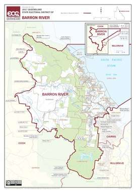 Map of the electoral district of Barron River, 2017 | |||||||||||||||
| State | Queensland | ||||||||||||||
| Dates current | 1972–present | ||||||||||||||
| MP | Craig Crawford | ||||||||||||||
| Party | Labor | ||||||||||||||
| Namesake | T C Barron, police clerk | ||||||||||||||
| Electors | 34,684 (2017) | ||||||||||||||
| Area | 813 km2 (313.9 sq mi) | ||||||||||||||
| Coordinates | 16°51′S 145°44′E / 16.850°S 145.733°ECoordinates: 16°51′S 145°44′E / 16.850°S 145.733°E | ||||||||||||||
| |||||||||||||||
2008 Electoral map
Barron River is an electoral district of the Legislative Assembly in the Australian state of Queensland.
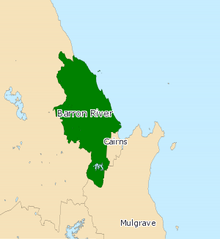
Created at the 1971 redistribution, it currently covers the northern suburbs of Cairns, as well as Kuranda. The Barron River from which the electorate derives its name runs through its centre. It is bordered by the districts of Cook to the north and west, Cairns to the southeast and Mulgrave to the south.
Members for Barron River
| Member | Party | Term | |
|---|---|---|---|
| Bill Wood | Labor | 1972–1974 | |
| Martin Tenni | National | 1974–1989 | |
| Lesley Clark | Labor | 1989–1995 | |
| Lyn Warwick | Liberal | 1995–1998 | |
| Lesley Clark | Labor | 1998–2006 | |
| Steve Wettenhall | Labor | 2006–2012 | |
| Michael Trout | Liberal National | 2012–2015 | |
| Craig Crawford | Labor | 2015–present | |
Election results
| Party | Candidate | Votes | % | ± | |
|---|---|---|---|---|---|
| Labor | Craig Crawford | 9,497 | 33.5 | −6.0 | |
| Liberal National | Michael Trout | 8,686 | 30.6 | −10.4 | |
| One Nation | Andrew Schebella | 4,760 | 16.8 | +16.8 | |
| Greens | Cameron Boyd | 3,551 | 12.5 | +2.2 | |
| Independent | Cheryl Tonkin | 1,039 | 3.7 | +3.7 | |
| Independent | Andrew Hodgetts | 826 | 2.9 | +2.9 | |
| Total formal votes | 28,359 | 95.4 | −2.5 | ||
| Informal votes | 1,380 | 4.6 | +2.5 | ||
| Turnout | 29,739 | 84.0 | −3.0 | ||
| Two-party-preferred result | |||||
| Labor | Craig Crawford | 14,707 | 51.9 | −1.7 | |
| Liberal National | Michael Trout | 13,652 | 48.1 | +1.7 | |
| Labor hold | Swing | −1.7 | |||
References
External links
- Electorate Profile (Antony Green, ABC)
This article is issued from
Wikipedia.
The text is licensed under Creative Commons - Attribution - Sharealike.
Additional terms may apply for the media files.