Kulang Fort
| Kulang Fort,कुलंग गड | |
|---|---|
| Part of Kalsubai Range | |
| Nashik district, Maharashtra | |
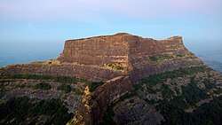 Kulang fort from Madangad Fort | |
 Kulang Fort,कुलंग गड | |
| Coordinates | 19°35′30.1″N 73°38′21.4″E / 19.591694°N 73.639278°E |
| Type | Hill fort |
| Height | 4825 feet[1] |
| Site information | |
| Owner | Government of India |
| Open to the public | Yes |
| Condition | Ruins |
| Site history | |
| Built | Satvahan Era |
| Materials | Stone |
| Grade | Tough |
Kulang fort (कुलंग गड ) is located in the Igatpuri area of Nashik district, on the western side of the Kalsubai hill range. This fort is adjacent to the Madangad and Alang forts, all of which were constructed to protect the Nashik-Kalyan ancient commercial road.
History
In 1760 the fort were probably ceded by the Moghuls to the Peshwa along with many other forts in the Nashik region. In 1818 Kulang along with the other nearby forts were captured by the British forces.[2] The British, however did not destroy the steps of this fort.
Places to see
There are few rock cut cisterns and a cave on the fort. There is no significant construction on the fort, except for a Wada made from stone masonry and the ruined main gate. The pathway to the fort is made of rock cut steps. From the top of this fort Kalsubai peak, Patta, Aundha, Madangad Fort, Alang Fort and Ratangad forts are easily visible.
How to reach
There is a base village Ambevadi or Kurangwadi, from which it takes about two to three hours to reach the fort. The path passes through a dense forest area, the Kalsubai-Harishchandragad Wildlife Sanctuary.[3] There is potable water on the way and plenty of clean water on the fort. There are spacious caves on the fort which could accommodate up to 100 persons. There is no fuel wood on the fort, so it is preferable to carry fuel wood or a gas-stove from the base village.
Gallery
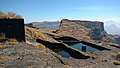 Water cisterns
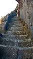 Rock cut steps
References
- ↑ "Kulang, Sahyadri,Shivaji,Trekking,Marathi,Maharastra".
- ↑ https://cultural.maharashtra.gov.in/ english/gazetteer/Nasik/022%20Places/001%20Place.htm#Kulang
- ↑ NIC). "Maharashtra Forest Department".