Gambhirgad
| Gambhirgad Fort | |
|---|---|
| गंभीरगड | |
| Part of Palghar Hill Range | |
| Palghar district, Maharashtra | |
 Gambhirgad fort | |
 Gambhirgad Fort  Gambhirgad Fort | |
| Coordinates | 20°03′18.3″N 73°03′01.5″E / 20.055083°N 73.050417°E |
| Type | Hill fort |
| Height | 2252 Ft. |
| Site information | |
| Owner | Government of India |
| Controlled by |
|
| Open to the public | Yes |
| Condition | Ruins |
| Site history | |
| Materials | Stone |
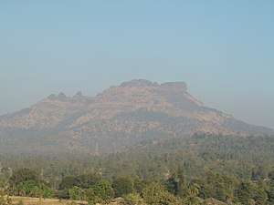
Gambhirgad Fort ( Marathi: गंभीरगड ) is a fort located 58km from Dahanu, Palghar district, of Maharashtra. This fort is less important fort in Palghar district. The fort is in ruins and restoration is to be done.
History
No history about the fort is available
How to reach
The nearest town is Kasa which is 26km from Dahanu. The base village of the fort is Patilpada which is 32km from Kasa. There are good hotels at Kasa, now tea and snacks are also available in small hotels at Saiwan. The trekking path starts from the hillock south of the Patilpada. The route is very safe and wide. There are no trees on the trekking route. It takes about an hour to reach the entrance gate of the fort.[1]
Places to see
There are water cisterns, small temple and a bastion on the fort. It takes about an hour to visit all places on the fort.
Coordinates: 20°03′18.3″N 73°03′01.5″E / 20.055083°N 73.050417°E
See also
References
| Rulers | |
|---|---|
| Peshwas | |
| Amatya | |
| Pratinidhi |
|
| Women | |
| Maratha Confederacy |
|
| Battles |
|
| Wars | |
| Adversaries | |
| Forts | |
| Coins | |