Kalinjar Fort
| Kalinjar Fort | |
|---|---|
| Part of Banda district | |
| Uttar Pradesh, India | |
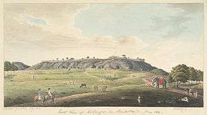 A view of Kalinjar Fort | |
 Kalinjar Fort | |
| Coordinates | 24°59′59″N 80°29′07″E / 24.9997°N 80.4852°E |
| Type | Fort, Caves & Temples |
| Site information | |
| Controlled by | Government of Uttar Pradesh |
| Open to the public | Yes |
| Condition | Ruined Citadel |
| Site history | |
| Built | 10th century |
| Materials | Granite Stones |
| Battles/wars | Mahmud of Ghazni 1023, Sher Shah Suri 1545, British 1812 & Revolt of 1857 |
| Garrison information | |
| Past commanders | Chandel dynasty of Rajputs & Solankis of Rewa |
| Garrison | British garrison 1947 |
|
Kalinjar (Hindi: कालिंजर) is a fortress-city in the Bundelkhand region of central India. Kalinjar is located in Banda District of Uttar Pradesh state, near the temple-city and World Heritage Site of Khajuraho. The fortress is strategically located on an isolated rocky hill at the end the Vindhya Range, at an elevation of 1,203 feet (367 m) and overlooks the plains of Bundelkhand. It served several of Bundelkhand's ruling dynasties, including the Chandela dynasty of Rajputs in the 10th century, and the Solankis of Rewa. The fortress contains several temples dating as far back as the Gupta dynasty of the 3rd-5th centuries.
History
Kalinjar means The destroyer of time in Sanskrit. 'Kal' is time and 'jar' destruction. Legend says that after manthan Hindu God, Lord Shiva, drank the poison and his throat became blue (hence the name Neel (blue) Kantha (throat)) and he came to Kalinjar and overcome the 'Kal' i.e. he achieved victory over death. This is the reason the Shiva temple at Kalinjar is called Neelkanth. Since then, the hill has been considered a holy site, casting its shadow across the patches of grasslands as well as the densely forested valley. The natural splendor of the surroundings makes it an ideal place for penance and meditation and, surprisingly, a strange mystique still pervades all over the hill.
The term "Kalinjar" (as "Kalanjara") appears in ancient Hindu mythology, but the exact origins of the fort itself are uncertain. According to the 16th century Persian historian Firishta, the town of Kalinjar was established by one Kedar Raja in 7th century. The fort came to prominence during the Chandela rule. According to Chandela-era legends, the fort was built by a Chandela ruler.[1] The Chandela rulers used the title Kalanjaradhipati ("Lord of Kalanjara"), which shows the importance they attached to the fort.[2]
Its historical background is replete with numerous battles and invasions. The Hindu princes of different dynasties as well as the Muslim rulers fought hard to conquer it and the fort continued to pass from one ruler to another. But, except the Mughals, no other ruler could reign over it for long.
In 1023 Mahmud of Ghazni attacked and received a tribute from Kalinjar,[3][4] Mughal Emperor Babur was the only commander in history to have captured the fort in 1526 when driving away Raja Hasan Khan Mewattpati. It was also the place where Sher Shah Suri met his death in 1545 when he was killed either in the fort or nearby on the grounds. In 1569 Akbar captured the fort and it was under Mughal Rule till the British occupation. Kalinjar played a prominent part in history down to the time of the Revolt of 1857, when it was held by a small British garrison. Both the fort and the town, which stands at the foot of the hill, are of interest to the antiquary on account of the remains of temples, sculptures, inscriptions and caves.
In 1812, the British troops marched into Bundelkhand. After a long battle they were able to annex the fort. The British seizure of Kalinjar proved to be a great watershed, transferring the legacy of the old aristocracy into the hands of the new bureaucracy of officials who showed their loyalty to British imperialism by damaging the captured fort. The damages caused to the fort can still be seen on its walls and open spaces.
Transport links
- Air
The nearest airport is at Khajuraho, 130 kilometres (81 mi) away.
- Rail
The nearest railway station is at Atarra 36 kilometres (22 mi) away, on the Banda-Satna route, 57 kilometres (35 mi) from Banda Railway Station.
- Road
The Kalinjar fort is linked by road to all the important centres in the region with regular bus services. Some of the major road distances are: Chitrakoot, 78 kilometres (48 mi); Banda, 62 kilometres (39 mi); Khajuraho, 130 kilometres (81 mi); and Allahabad, 205 kilometres (127 mi).
Gallery
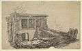 Pillared building at one corner of Kalinjar Fort
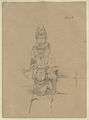 Kuvera riding on his vehicle, near temple of Nilkanth
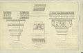 Architectural details from temple of Nilkanth
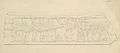 Kurma avatar
 Varaha avatar
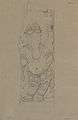 Sculpture of Ganesh from temple of Nilkanth
 Temple in the Fort
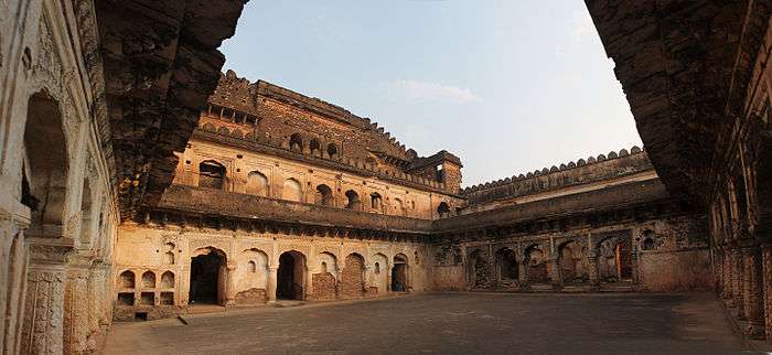
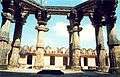 Fort (inside view)
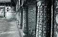 Pillar inside Rani Palace, Kalinjar Fort
References
- ↑ Edwin Felix T. Atkinson (1874). Statistical, descriptive and historical account of the North-western Provinces of India, ed. by E.T. Atkinson [and others]. pp. 449–451.
- ↑ Finbarr Barry Flood (2009). Objects of Translation: Material Culture and Medieval "Hindu-Muslim" Encounter. Princeton University Press. p. 80. ISBN 0-691-12594-5.
- ↑ Iqtidar Alam Khan, Ganda Chandella, Historical Dictionary of Medieval India, (Scarecrow Press, 2007), 66.
- ↑ Raj Kumar, History Of The Chamar Dynasty : (From 6Th Century A.D. To 12Th Century A.D.), (Kalpaz Publications, 2008), 127.