Fort (Mumbai precinct)
| Fort | |
|---|---|
| Neighborhood | |
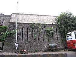 Remains of the Fort George walls | |
 Fort | |
| Coordinates: 18°56′06″N 72°50′09″E / 18.935°N 72.8359°ECoordinates: 18°56′06″N 72°50′09″E / 18.935°N 72.8359°E | |
| Country | India |
| State | Maharashtra |
| District | Mumbai City |
| Metro | Mumbai |
| Zone | 1 |
| Ward | A |
| Government | |
| • Type | Municipal corporation |
| • Body | MCGM |
| Elevation | 11 m (36 ft) |
| Languages | |
| • Official | Marathi |
| Time zone | UTC+5:30 (IST) |
| PIN | 400 001 |
| Lok Sabha constituency | Mumbai South |
| Civic agency | MCGM |
Fort is a Business District in Mumbai, India. The area gets its name from the defensive fort, Fort George, built by the British East India Company around Bombay Castle. The area extends from the docks in the east, to Azad Maidan in the west; Victoria Terminus in the north to Kala Ghoda in the south. This area is the heart of the financial area of the city. Many British era structures are located here.
History
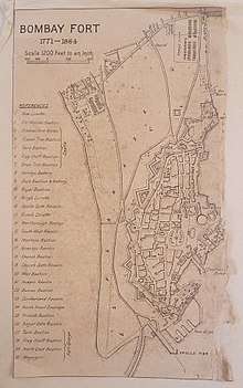
Map of Bombay Fort, 1771
The Fort area was declared protected under regulations of the Maharashtra Government Urban Development Department. An advisory committee now oversees the development, repairs and renovations of structures in the precinct.
See also
External links
| Wikimedia Commons has media related to Bombay Fort. |
See also
This article is issued from
Wikipedia.
The text is licensed under Creative Commons - Attribution - Sharealike.
Additional terms may apply for the media files.