Fierza (reservoir)
| Fierza Reservoir | |
|---|---|
 | |
| Country | Albania |
| Coordinates | 42°15′0″N 20°2′30″E / 42.25000°N 20.04167°ECoordinates: 42°15′0″N 20°2′30″E / 42.25000°N 20.04167°E |
| Reservoir | |
| Total capacity | 27,000,000,000 m3 (9.5×10¹¹ cu ft)[1] |
| Catchment area | 11,829 km2 (4,567 sq mi) |
| Surface area | 72.5 km2 (28.0 sq mi) |
| Maximum water depth | 128 m (420 ft) |
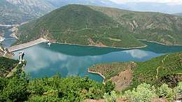
The Fierza Reservoir (Albanian: Liqeni i Fierzës) is a reservoir in Albania and Kosovo. The Drin River and parts of the White Drin and Black Drin also runs through the reservoir. The size of the lake is 72.6 km2 (28.0 sq mi), of which 2.46 km² belong to Kosovo. It is 70 km long and has a depth of 128 m. In the Albanian side of the lake there are many canyons and some small islands. The dam is 167m tall.[2] In 2014, the lake was declared a Regional Nature Park by the Kukes County Council.[3]
The reservoir was formed as a result of the construction of the Fierza Hydroelectric Power Station in 1978 by the Albanian government.
See also
| Wikimedia Commons has media related to Lake Fierza. |
References
- ↑ The Protection of Critical Energy Infrastructure Against Emerging Security Challenges (A. Niglia ed.). IOS Press. p. 131. ISBN 9781614995722.
- ↑ Paul G. Marinos (1 January 2001). Engineering Geology and the Environment. A.A. Balkema. p. 3707. ISBN 978-90-5410-882-5. Retrieved 26 September 2013.
- ↑ http://www.kqk.gov.al/per-shpalljen-e-ekosistemit-natyror-te-liqenit-te-fierzes-park-natyror-rajonal
This article is issued from
Wikipedia.
The text is licensed under Creative Commons - Attribution - Sharealike.
Additional terms may apply for the media files.