Drin River
| Drin | |
| River | |
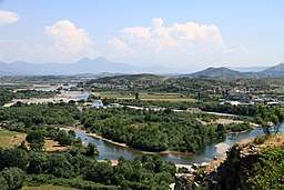 Drin River Delta in Shkodër | |
| Countries | Albania, Kosovo, Macedonia |
|---|---|
| Region | Southern Europe |
| Tributaries | |
| - left | White Drin, Mirusha, Prizren, Toplluha |
| - right | Black Drin, Sateska, Radika, Perro, Bushtrica, White Drin: Peć, Dečani, Erenik, Dečani, Black Drin: Valbona, Shala |
| Cities | Prizren, Shkodër, Kukës, Lezhë, Struga, Debar, Peshkopi, Maqellarë |
| Secondary source | Black Drin at Lake Ohrid near Struga |
| - location | Macedonia, Struga Municipality |
| Additional source | White Drin at Zhleb Mountains near Radavc |
| - location | Kosovo, Peja District |
| Source confluence | Near Kukës |
| - location | Kukës County, Albania |
| Mouth | Large Drin: Buna River Small Drin: Gulf of Drin |
| - location | Large Drin: Shkodër County Small Drin: Lezhë County, Albania |
| - elevation | 5 m (16 ft) |
| Length | 335 km (208 mi) |
| Basin | 19,686[1] km2 (7,601 sq mi) |
| Discharge | for the river mouth |
| - average | 352 m3/s (12,431 cu ft/s) |
| - max | 1,800[2] m3/s (63,566 cu ft/s) |
| Progression | Adriatic Sea |
The Drin or Drim (/driːn/;[3] Albanian: Drin [dɾin] or Drini [ˈdɾini]; Macedonian: Дрим, translit. Drim [drim]) is a river in Southern and Southeastern Europe with two distributaries one discharging into the Adriatic Sea and the other one into the Buna River. Its catchment area extends across Albania, Kosovo, Greece, Montenegro and the Republic of Macedonia.[4][5] The river and its tributaries form the Gulf of Drin, an ocean basin that encompasses the northern Albanian Adriatic Sea Coast.
At 335 kilometres (208 miles) long, the Drin is the longest river of Albania of which 285 kilometres (177 miles) passes across Albania and the remainder through Kosovo and Macedonia. It starts at the confluence of its two headwaters, namely the Black Drin and White Drin. It originates in the mountainous northern mountain range, flows westwards through the Albanian Alps and Dukagjin Highlands, and eventually drains into the Adriatic Sea, between Shëngjin and Durrës. Numerous lakes and reservoirs are formed by the river or flow into it such as the Fierza Lake and Koman Lake.
Located in the Balkan Peninsula at the crossroad of Europe and Asia, the river basin's varied climate and topography have shaped a vast array of flora and fauna. In addition, it has been recognised as one of the most important biodiversity hotspots in Europe.[6][7] The Drin Delta is classified as an Important Bird Area of international importance by designation under the BirdLife International Convention.[8]
Overview
The Drin originates near the town of Kukës, in the northeast of Albania, at the confluence of the rivers Black Drin and White Drin. It then flows west for about 335 km (208 mi) passing through the Albanian Alps and Fierzë then upon reaching the Dukagjini highlands, flowing then to the south through Apripë e Gurit, Toplanë, Dushman, Koman, Vjerdhë Mazrrek, Rragam, and Pale Lalej. At Vau i Dejës, it enters the low Shkodër Field and splits into two arms. One empties into the Bay of Drin into the Adriatic Sea southwest of Lezhë, forming the Mouth of Drin, Albanian: Gryk' e Drinit). The other empties into the Bojana River near the Rozafa Castle.
Measured from the source of White Drin, the rivers length is 335 km (208 mi), making it the longest river in Albania.[5] The Black Drin flows out from the Lake Ohrid near Struga and flow through eastern Albania and western Macedonia. The White Drin originates from the Zhleb mountain, north of the town of Pejë in the Dukagjin region of Kosovo,[lower-alpha 1] and flows from there through to Albania.[9]
The basin encompasses the transboundary subbasins of Lake Shkodër (largest lake in Southern Europe)[10], Lake Ohrid (one of the most ancient lakes in the World)[11], Lake Prespa and Small Prespa Lake and also the tributaries, namely Black Drin, White Drin and Buna River. All these subbasins and tributaries are home to numerous species of mammals, vascular plants, insects, amphibians, fish and birds.
The Drin is extremely important for the Albanian economy, especially for its electrical production. Four hydropower facilities produce most of Albania's electricity (over 1200MW capacity). The artificial Lake Fierza (Albanian: Liqeni i Fierzës) created by the dam at Fierzë is the largest artificial lake in Albania with its surface of 73 km². The second largest artificial lake is also built on this river. Vau i Dejës lake (Albanian: Liqeni i Vaut të Dejës) has an area of 25 km². Construction of the Fierza power station caused some controversy in the 1980s. Without reaching any agreement, the Albanian government ordered the reservoir to be filled with water, which flooded some border areas of Kosovo, then part of Yugoslavia. The Yugoslav government protested, but no solution was agreed on. Thus, today, Lake Fierza is shared by Albania and Kosovo.
See also
| Wikimedia Commons has media related to River Drin. |
Notes
- ↑ Kosovo is the subject of a territorial dispute between the Republic of Kosovo and the Republic of Serbia. The Republic of Kosovo unilaterally declared independence on 17 February 2008, but Serbia continues to claim it as part of its own sovereign territory. The two governments began to normalise relations in 2013, as part of the Brussels Agreement. Kosovo has received formal recognition as an independent state from 113 out of 193 United Nations member states.
Further reading
References
- ↑ Elisabeta Poci. "HYDROLOGY OF THE TRANSBOUNDARY DRIN RIVER BASIN" (PDF). ce.utexas.edu. University of Texas at Austin.
- ↑ Food and Agriculture Organization of the United Nations. "ALBANIA". fao.org.
- ↑ "Drin". dictionary.com.
- ↑ "Internationally Shared Surface Water Bodies in the Balkan Region". inweb.gr.
- 1 2 Tom Streissguth (2011). Albania in Pictures. Twenty-First Century Books. p. 12. ISBN 978-0-7613-6378-1. Retrieved 26 September 2013.
- ↑ "The natural wealth and legacy of the Drin River Basin: inspiring our collective actions" (PDF). act4drin.net. p. 7.
- ↑ "Drin River Basin The blue heart of the Balkans" (PDF). mio-ecsde.org. p. 4.
- ↑ BirdLife International. "Drini Delta". datazone.birdlife.org.
- ↑ Klement Tockner; Urs Uehlinger; Christopher T. Robinson (31 January 2009). Rivers of Europe. Academic Press. p. 1156. ISBN 978-0-08-091908-9. Retrieved 26 September 2013.
- ↑ "A new freshwater snail genus (Hydrobiidae, Gastropoda) from Montenegro, with a discussion on gastropod diversity and endemism in Skadar Lake". zookeys.pensoft.net. Retrieved 28 March 2013.
- ↑ "Natural and Cultural Heritage of the Ohrid region". whc.unesco.org. pp. UNESCO.
Situated on the shores of Lake Ohrid, the town of Ohrid is one of the oldest human settlements in Europe; Lake Ohrid is a superlative natural phenomenon, providing refuge for numerous endemic and relict freshwater species of flora and fauna dating from the tertiary period. As a deep and ancient lake of tectonic origin, Lake Ohrid has existed continuously for approximately two to three million years.