Krishnarajapuram
| Krishnarajapuram KR Puram | |
|---|---|
| suburb | |
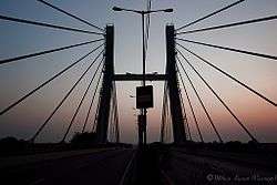 A straight view of the hanging bridge built on the National Highway 4, right over the Krishnarajapuram Railway station | |
 Krishnarajapuram | |
| Coordinates: 12°59′42″N 77°40′48″E / 12.995°N 77.68°ECoordinates: 12°59′42″N 77°40′48″E / 12.995°N 77.68°E | |
| Country | India |
| State | Karnataka |
| District | Bangalore |
| Metro | Bangalore |
| Population (2001) | |
| • Total | 187,453 |
| Languages | |
| • Official | Kannada |
| Time zone | UTC+5:30 (IST) |
| Vehicle registration | KA-53 |
Krishnarajapuram (Railway Station Code : KJM), also known as KR Puram, is an outlying neighborhood of Bangalore in the Indian state of Karnataka. It's one of the zones of BBMP. It is located 15 km from Bangalore City railway station. Old Madras Road is partially located in Krishnarajapuram. A lake called 'Vengayyana Lake' is in the heart of this area. The Yelemallappa Shetty lake near Medahalli, situated just outside the eastern limits of Krishnarajapuram, is one of the largest lakes in Bangalore.
Krishnarajapuram is the headquarters of the Bangalore-East taluk and as such, houses a large number of government offices. It is also a Karnataka Legislative Assembly/State assembly constituency. B A Basvaraja of the Indian National Congress (INC) was elected as the Member of Legislative assembly from this constituency in the 2013 Karnataka Assembly election[1], and re-elected in 2018. It is a part of the Bangalore North Lok Sabha constituency.
The area's name is said to come from Krishnaraja Wadiyar III, who ruled the provincial state of Mysore from 1799 to 1868[2].
Connectivity
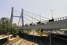
Krishnarajapuram is located at the junction of Old Madras Road and Outer Ring Road. Krishnarajapuram Railway station falls on the Bangalore - Chennai broad gauge line. The cable bridge on the junction of Old Madras Road and Outer Ring Road was built by Afcons for IRCON and inaugurated the by then Prime Minister of India, Atal Bihari Vajpayee in 2003 Feb and was subsequently declared as the Most Outstanding National Bridge by the Indian Institution of Bridge Engineers.[3][4]
Demographics
As of 2001 India census,[5] Krishnarajapuram had a population of 187,453. Males constitute 52% of the population and females 48%. Krishnarajapuram has an average literacy rate of 78%, higher than the national average of 59.5%: male literacy is 83%, and female literacy is 71%. In Krishnarajapuram, 11% of the population is under 6 years of age.
References
![]()
- ↑ http://bangalore.citizenmatters.in/articles/view/5263-assembly-elections-result-bangalore
- ↑ https://economictimes.indiatimes.com/news/politics-and-nation/date-with-history-kr-purams-history-is-as-entangled-as-its-present-geography/articleshow/46619038.cms. Retrieved 2018-10-07. Missing or empty
|title=(help) - ↑ "Cable Stayed Bridge at Krishnarajapura". Afcons. Retrieved 31 March 2012.
- ↑ "K R Pura bridge is India's best". Hubli: The Times of India. 2009-03-17. Retrieved 31 March 2012.
- ↑ "Census of India 2001: Data from the 2001 Census, including cities, villages and towns (Provisional)". Census Commission of India. Archived from the original on 2004-06-16. Retrieved 2008-11-01.
5. Upcoming Project at KR Puram by Sobha Limited - Sobha Lake Garden