Kipling station
Kipling | |||||||||||
|---|---|---|---|---|---|---|---|---|---|---|---|
 | |||||||||||
| Location |
950 Kipling Avenue Toronto, Ontario Canada | ||||||||||
| Coordinates | 43°38′14″N 79°32′10″W / 43.63722°N 79.53611°WCoordinates: 43°38′14″N 79°32′10″W / 43.63722°N 79.53611°W | ||||||||||
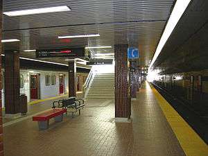
| Platforms | Centre platform | ||||||||||
| Tracks | 2 | ||||||||||
| Connections |
| ||||||||||
| Construction | |||||||||||
| Structure type | At grade | ||||||||||
| Parking | 1465 spaces[1] | ||||||||||
| Disabled access | Yes | ||||||||||
| History | |||||||||||
| Opened | November 21, 1980[2] | ||||||||||
| Traffic | |||||||||||
| Passengers (2016[3]) | 49,870 | ||||||||||
| Services | |||||||||||
| |||||||||||
Kipling is the western terminus of the Line 2 Bloor–Danforth of the Toronto subway system. The station is served by buses and subway trains operated by the Toronto Transit Commission and is adjacent to the Kipling GO Station on the Milton line of GO Transit. It is located in the Islington–City Centre West neighbourhood on St. Albans Road at Aukland Road, west of the overpass of Kipling Avenue, after which the station is named. The Toronto Parking Authority operates three commuter parking lots near the station.[4] Notably, Kipling is the departing and arriving point for the 192 Airport Rocket bus route, which provides quick and frequent service between Toronto's subway system and Toronto Pearson International Airport.
History
Kipling station, in what was then the Borough of Etobicoke, officially opened on November 21, 1980,[2] but not until the following day[5] was it opened to the public, along with Kennedy station as part of east-west extensions to the Bloor–Danforth line. Kipling and Kennedy were designed similarly, with both stations having a centre platform allowing trains to stop at either side. The platform walls in Kipling are yellow with black stripes and show the station's name in Univers.[6]
As a result of the initial lack of density near the station, and its location near a hydro substation, it was originally designed around commuter travel, with a large amount of parking space and a roughed-in platform for a future light rail or light metro line, like the Scarborough RT at Kennedy.[7] Due to this design, the area around Kipling station is considered to be a travel hub and it is being further developed to contain a regional bus platform as well as improved access to the adjacent Kipling GO Station.[8]
In 1999, this station became accessible with elevators.
Facilities
The main entrance is located at the west end of Kipling station, with access to the GO station, commuter parking lots, and a kiss and ride area for passenger drop-off. An entrance at the east end makes the bus platform level accessible by way of a ramp, with an elevator providing a connection with the train platform below.[9] Fares can be paid for at this station by using tokens, tickets, passes, as well as the Presto smart card.[10] Currently it serves the high density residential and commercial developments that are being built, while acting as a hub for commuter travel.
Above the subway tracks on the south side of the station, opposite the bus bays on the same level, is an unfinished platform for a proposed but unbuilt Etobicoke RT line similar to Line 3 Scarborough.[7]
East of the station towards Islington, the line continues on the surface alongside the railway right-of-way which parallels Dundas Street at a distance. It crosses over Bloor Street to the north side alongside the railway tracks, then dives underground below the tracks and turns parallel to Bloor.
Construction on a new 14-bay inter-regional bus terminal is underway and is scheduled to be completed in 2019.[11] Upon completion, GO Transit buses will use the facility, and Mississauga Transit buses terminate at Kipling station instead of Islington. The current parking facilities will be reconfigured to allow for the construction of the terminal. The modernization project will also include landscaping and revitalization of interior and exterior station finishes and lighting.[12]
Surface connections
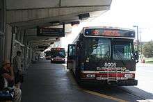
The bus platform is in the fare-paid zone, allowing passengers to quickly transfer between the subway and the following bus routes:[13]
TTC routes serving the station include:
| Route | Name | Additional Information |
|---|---|---|
| 30A | Lambton | Eastbound to High Park Station |
| 30B | Eastbound to High Park via High Park Station | |
| 44 | Kipling South | Southbound to Lake Shore Boulevard and Humber College Lakeshore Campus |
| 45A | Kipling | Northbound to Steeles Avenue West past Etobicoke North GO Station |
| 45B | Northbound to Carlingview Drive via Belfield Road | |
| 45E | Northbound to Steeles Avenue West (Rush hour express service) | |
| 46 | Martin Grove | Northbound to Steeles Avenue West |
| 49 | Bloor West | Westbound to Markland Wood (west of Highway 427) |
| 111 | East Mall | Northbound to Eglinton Avenue West (Willowridge & Richgrove) |
| 112B | West Mall | Northbound to Renforth station |
| 112C | Northbound to Disco Road | |
| 123B | Sherway | Southbound to Long Branch Loop via Shorncliffe Road and The East Mall |
| 123C | Southbound to Long Branch Loop via Shorncliffe Road and North Queen Street | |
| 123D | Southbound to Sherway Gardens via Shorncliffe Road and The East Mall | |
| 123F | Southbound to Sherway Gardens via The West Mall (Rush hour express service) | |
| 188 | Kipling South Rocket | Southbound to Lake Shore Boulevard and Humber College Lakeshore Campus (Weekday express service) |
| 192 | Airport Rocket | Northbound to Toronto Pearson International Airport (Express service) |
| 927A | Highway 27 Express | Northbound to Humber College North Campus |
| 927B | Northbound to Steeles Avenue West | |
| 927C | Northbound to Humber College via Attwell Drive (Rush hour service) | |
| 927D | Northbound to Steeles Avenue West via Royalcrest Road (Rush hour service) | |
| 300A | Bloor–Danforth Blue Night | Westbound to Toronto Pearson International Airport |
| Eastbound to Warden Avenue & Danforth Road | ||
| 300B | Westbound to The West Mall & Burnhamthorpe Road | |
| Eastbound to Kennedy station |
- Some 300 Bloor–Danforth trips do not enter the bus terminal, but can be accessed at Aukland Road at Dundas Street.
- An IKEA Etobicoke customer courtesy shuttle (not a TTC route), departs from Subway Crescent[14] north of the Kiss and ride area.
- MiWay bus routes do not directly connect to the station, unlike at Islington. Buses can be boarded and dropped off on Dundas Street at Aukland Road. It is considered an accessible connection between MiWay and the TTC.
References
- ↑ "Parking". Kipling Station. Toronto Transit Commission. Retrieved 11 August 2012.
- 1 2 "The Built Subways". Transit Toronto. Retrieved 7 July 2014.
- ↑ "Subway ridership, 2016" (PDF). Toronto Transit Commission. Retrieved July 3, 2018.
This table shows the typical number of customer-trips made on each subway on an average weekday and the typical number of customers travelling to and from each station platform on an average weekday.
- ↑ "Kipling Station". Find Parking. Toronto Parking Authority (Green P). Retrieved 11 August 2012.
- ↑ "New Kipling Station". The Toronto Star. November 20, 1980. p. A18.
- ↑ Blackett, Matthew (March 25, 2008). "Ride the Rainbow of the Bloor–Danforth". Spacing Toronto. Retrieved July 29, 2012.
- 1 2 Bateman, Chris (June 23, 2012). "Whatever Happened to the Etobicoke RT?". blogTO. Retrieved July 28, 2012.
- ↑ "Kipling Station Redevelopment Handover to GO Transit". Toronto Transit Commission. Retrieved July 28, 2012.
- ↑ Kipling: Accessible Alternative
- ↑ "PRESTO card". Presto card official Twitter feed. July 21, 2010. Retrieved July 24, 2010.
- ↑ "Kipling Mobility Hub". Retrieved 2018-10-04.
- ↑ White, Craig (August 5, 2010). "Kipling Subway Station's East Entrance On Its Way". urbantoronto.ca. Retrieved July 28, 2012.
- ↑ Kipling Station: Connections to
- ↑ IKEA Etobicoke: Store information
External links
| Wikimedia Commons has media related to Kipling station. |