Kipling Avenue
| |
|---|---|
 Kipling Ave. within Toronto | |
| Route information | |
|
Maintained by City of Toronto City of Vaughan | |
| Length | 26.4 km[1][2][3] (16.4 mi) |
| Major junctions | |
| South end | Lake Shore Boulevard |
|
Gardiner Expressway The Queensway Bloor Street / Dundas Street Burnhamthorpe Road Eglinton Avenue Dixon Road Rexdale Boulevard Albion Road Finch Avenue Steeles Avenue ------Course Break------ ------Course Break------ | |
| North end | King-Vaughan Road |
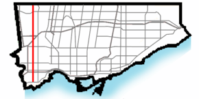
Kipling Avenue, originally named Mimico Avenue,[4] is a street in the Cities of Toronto and Vaughan in Ontario, Canada. It is a concession road, 6 concessions (12 km) from Yonge Street, and is a major north–south arterial road. It consists of three separate sections, with total combined length of 26.4 km. (16.4 mi.).
The street was surveyed in 1795 as a Meridian Street south of the east-west Meridian (now Rathburn Road) with lots to the east running east–west and lots to the west running north–south,[5] a pattern later subdivisions preserved in modern side streets. Most of the road traverses residential neighbourhoods and pockets of industrial and commercial hubs.
The street travels through the district of Etobicoke and passes such areas as New Toronto, Etobicoke Centre, Richview, and Rexdale.
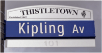
Originally named Mimico Avenue, the street became a central street for the lake shore municipalities of New Toronto (in which it is situated) and Long Branch. It is believed (but unproven) that the street was named in honour of Rudyard Kipling, author of such works as The Jungle Book and the Just So Stories, in preparation for a planned visit to Woodbridge in 1907. Kipling cancelled at the last moment, but the street retained the name.[6]
The Kipling Avenue section in the Town of New Toronto also reverted to its alternate name, Eighteenth Street, at least twice.
The Toronto Transit Commission's 45 Kipling, 44 Kipling South and 188 Kipling South Rocket bus routes operate from Kipling Station on the Bloor-Danforth line. These surface routes provide service along the length of the road.
Kipling Avenue was extended south of Lake Shore Boulevard West with the development of the former Lakeshore Psychiatric Hospital grounds. In 2001 City Council renamed the southerly extension as "Colonel Samuel Smith Park Drive", after rejecting the City Surveyor's original suggestion of Eighteenth Street.[7]
The Six Points interchange with Bloor and Ontario's early Toronto-to-Hamilton highway, now Dundas has traditionally been Etobicoke's central intersection. In 1953 Etobicoke left York County and joined the newly formedMetropolitan Toronto launching a period of urbanization which included changing the Six Points intersection to use a number of bridges in 1961.[8] The interchange is now scheduled to be reconfigured to create an at-grade intersection.[9]
Film studio complex Kipling Studio located on 777 Kipling Avenue is part of Cinespace Film Studios.[10]
Landmarks
Sights along Kipling Avenue in Toronto (north to south):
- North Humber Park
- North Kipling Park
- North Kipling Junior Middle School
- North Albion Collegiate Institute
- Albion Centre
- Albion Arena
- Toronto Public Library Rexdale branch
- Kipling Heights Plaza
- Toronto Public Library Northern Elms branch
- Mississauga Private School
- Monsignor Percy Johnson C.S.S.
- Etobicoke North GO Station
- Westway Plaza
- Dixon Grove Junior Middle School
- Denfield Park
- Islington Golf Club
- Six Points interchange
- Kipling subway station
- Kipling GO Station
- Kipling-Queensway Mall
- Mimico Correctional Centre
- New Toronto Secondary School, now Lakeshore Collegiate Institute
- Humber College Lakeshore campus
- Father John Redmond Catholic Secondary School
- Colonel Samuel Smith Park
Beyond Toronto
Kipling Avenue remains one of two streets to go north of Steeles Avenue (due to the short southward bend of Steeles) and still be within the City of Toronto (the other being Midland Avenue). It ends abruptly at the Toronto-Vaughan border. North of that border, Kipling is a broken street and appears briefly from Highway 7 to Langstaff Road. Its original alignment becomes Clarence Street until Major Mackenzie Road. It begins abruptly again south of Teston Road before finally terminating at King-Vaughan Road.
See also
References
- ↑ Google (March 25, 2017). "Kipling Avenue route Toronto" (Map). Google Maps. Google. Retrieved March 25, 2017.
- ↑ Google (March 25, 2017). "Kipling Avenue route South Vaughan" (Map). Google Maps. Google. Retrieved March 25, 2017.
- ↑ Google (March 25, 2017). "Kipling Avenue route North Vaughan" (Map). Google Maps. Google. Retrieved March 25, 2017.
- ↑ Mimico, Etobicoke Township, York County, Province of Ontario, Chas. E. GOAD, 1890
- ↑ Survey of the Southern Part of Etobicoke Township, Abraham Iredell, 1795, Archives of Ontario
- ↑ Wise, Leonard; Gould, Allan (2000). Toronto Street Names. Firefly Books. p. 128. ISBN 1-55209-386-7.
- ↑ http://www.toronto.ca/legdocs/2001/agendas/council/cc010306/et2rpt/cl012.pdf
- ↑ "Six Points Interchange". The Globe and Mail. Toronto. 1961-08-08. p. 13.
- ↑ Six Points Interchange Reconfiguration - EA goes to committee on November 29th | Toronto Coalition for Active Transportation
- ↑ "Toronto's Cinespace Film Studios Announces New Film Studio Development". Marketwire. December 15, 2009. Archived from the original on October 11, 2011. Retrieved October 18, 2011.
External links
Major roads, highways and streets in Toronto | |||||||||
|---|---|---|---|---|---|---|---|---|---|
| North–south |
| ||||||||
| East–west |
| ||||||||
| |||||||||
| |||||||||