King's Park, Glasgow
King's Park
| |
|---|---|
 Typical housing on King's Park Avenue | |
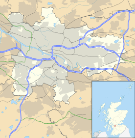 King's Park King's Park shown within Glasgow | |
| OS grid reference | NS596608 |
| Council area | |
| Lieutenancy area |
|
| Country | Scotland |
| Sovereign state | United Kingdom |
| Post town | GLASGOW |
| Postcode district | G44 |
| Dialling code | 0141 |
| Police | Scottish |
| Fire | Scottish |
| Ambulance | Scottish |
| EU Parliament | Scotland |
| UK Parliament | |
| Scottish Parliament | |
King's Park (Scottish Gaelic: Pàirc an Rìgh, Scots: Keeng's Pairk) is a district in the city of Glasgow, Scotland. It is situated south of the River Clyde.
Geography
King's Park is a residential area, with a mixture of semi-detached houses, flats (including cottage flats) and luxury detached houses. It is a ten- to twenty-minute bus or rail journey from Glasgow city centre. It was first developed for housing around 1930,[1] and retains much of the same appearance in the 21st century.
Named after the medium-sized park which lies within the boundaries of the district[2] and spotted with further green areas, much of King's Park is situated on an incline which overlooks Scotland's national stadium Hampden Park on one side, and the tower blocks of Castlemilk on the other.
The local 9-hole golf course is notable for being dug into a hillside 20-35° steep in some places. It is now closed and is used as an area of common ground; the golf course, and much of the park itself is actually located in neighbouring Croftfoot which was developed in the same era. King's Park also borders the Glasgow districts of Cathcart, Simshill, Mount Florida and Toryglen and the Rutherglen district of Bankhead.

The area is served by a rail station bearing the same name, although parts of the district are closer to Mount Florida or Croftfoot stations.
Demographics

King's Park is an affluent suburb of Glasgow, with median house prices and income well above average. In 2014, it was rated one of the most attractive postcode areas to live in Scotland.[3] As of 2005, it has a population of 14,552 residents. The ethnic makeup is approximately 98% White, 0.8% Asian, 0.6% Oriental and 0.6% mixed race.
Education

King's Park Secondary School in nearby Simshill is the local non-denominational comprehensive. The area is also served by Holyrood Secondary School in Govanhill, a Roman Catholic school and the largest secondary education institute in Europe. Primary schools in the area include King's Park, Croftfoot, St Fillans and St Mirin's.
Also located in King's Park, 32F Squadron are the first Scottish Squadron of the Air Training Corps who share some facilities with the Territorial Army base on the same site.
History
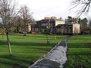
The "King's Park" after which the area is named features the landmark, Aikenhead House. Designed by the architect David Hamilton it was built in 1806 for the West Indies merchant and prominent Glasgow Tory, John Gordon.[2][1]
A scrapbook entitled Old Glasgow Street Songs etc and dated to 1850 at the Mitchell Library contains the song: The Dairy Maids Of Hundred-Acre Hill. This hill can be found in modern-day King's Park.
The State cinema, later a bingo venue (technically on the Rutherglen side of the territorial boundary), was a prominent landmark in the area from the 1930s until its demolition in the early 21st century.[4][2][5]
References
- 1 2 "Aikenhead House". The Glasgow Story. Retrieved 13 February 2018.
- 1 2 3 "Kings Park, Glasgow - origins & history". Glasgow's South Side. Retrieved 13 February 2018.
- ↑ "UK's 'most desirable' postcodes revealed". BBC News.
- ↑ "State Cinema". The Glasgow Story. Retrieved 13 February 2018.
- ↑ "State / County, Glasgow". The Scottish Cinema Project. Retrieved 9 September 2018.
External links
| Wikimedia Commons has media related to King's Park, Glasgow. |
- Friends of King's Park Local Interest Group.