Robroyston
Robroyston
| |
|---|---|
 Asda Robroyston store | |
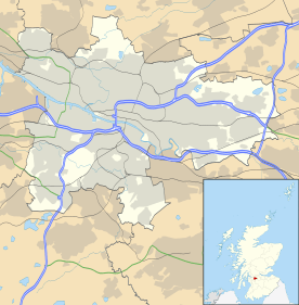 Robroyston Robroyston shown within Glasgow | |
| OS grid reference | NS637690 |
| Council area | |
| Lieutenancy area |
|
| Country | Scotland |
| Sovereign state | United Kingdom |
| Post town | GLASGOW |
| Postcode district | G33 |
| Dialling code | 0141 |
| Police | Scottish |
| Fire | Scottish |
| Ambulance | Scottish |
| EU Parliament | Scotland |
| UK Parliament | |
| Scottish Parliament | |
Robroyston (Scottish Gaelic: Baile Raibeart Ruadh) is a northeastern suburb of the city of Glasgow, Scotland.
To the north, it directly adjoins Auchinairn (part of Bishopbriggs) in the neighbouring East Dunbartonshire local authority area. The Glasgow neighbourhoods of Balornock and Barmulloch lie to the west, but these are largely separated from Robroyston by a nature reserve.[1] Land to the east towards North Lanarkshire is open countryside, which has made the area a popular location for housing developments. Land to the south is also unoccupied, but is on the opposite side of the M80 motorway, Junction 2 of which directly serves the area.
History

William Wallace
It was where Scottish leader William Wallace was turned over to English soldiers in 1305. At the site of Wallace's capture there stands a monument — there have also been proposals put forward for a visitors centre in the area, at the site of the monument. On the monument there is a plaque in Latin
'Dico tibi verum, libertas optimum rerum, nunquam servili sub nexu, vivito fili', which translates to 'I tell you the truth, the best of all things is freedom, never son, live under the bonds of slavery' which was taught to William Wallace in his boyhood.
About 200 yards from the monument, 'Wallace's Well' is located on the country road.[2]
Hospital
Robroyston Hospital was built as a municipal smallpox and tuberculosis hospital and opened in 1918.[3] It was temporarily used as a military hospital in 1918–19. By 1925, 450 beds at Robroyston were devoted to tuberculosis patients, almost half of Glasgow's total complement. In 1945 a maternity unit was added. In 1948, Robroyston joined the National Health Service under the Board of Management for Glasgow Northern Hospitals. In 1974 it was placed in the Northern District of the Greater Glasgow Health Board. It closed in 1977.
Housing developments

A small housing community of mainly minrers' rows formed the village of Robroyston c. 1929 to the east of the Barmulloch estates. At that time an open cast mine occupied the land that has now become Robroyston Park[4] and these houses were occupied mostly by workers. The Barmulloch housing estate was developed throughout the 1950s and in turn absorbed the original Robroyston village, comprising Zena Street (extended to Barmulloch), Earnock Street, Olive Street, Sheila Street, Winifred Street and Hilda Crescent, with most of the housing being cottage flats.
Throughout the 1990s, large-scale housing developments were undertaken to the north east of the original village in the land that was commonly known as Robroyston Mains[5] in this part of the Urban/rural fringe of Glasgow. The houses in the initial phase are within four clusters: Brookfield, Briarcroft, Glendale and Louden Hill. This drastically increased the population of the suburb to some 8300 people. As a result of the boom in population, the area became chronically deficient in infrastructure and provision of many local services, although this problem has been lessened somewhat by the construction of Asda and Aldi superstores.
.jpg)
Robroyston is underdeveloped in terms of community facilities, but a newly opened primary school (Wallacewell Primary) with community access out of hours is nearby. The Church of Scotland has responded to the growing needs of this new community by establishing Robroyston Church behind Asda at Saughs Drive in the Glendale Estate. Robroyston Church runs both Girls' and Boys' Brigades and employs two youth workers to work with the local teenagers. The church building is also used by a number of other organisations including a parent and toddler group.
.jpg)
The development of the Nova Technology Park[6] also looks to boost the local economy and jobs market. Currently, the area is dependent on neighbouring Bishopbriggs, however, a new development which will bring many new homes and leisure and health facilities, as well as a new train station, worth £300 million has been approved by Glasgow City Council,[7] so this should address the lack of facilities in Robroyston.[8]
Current status
.jpg)
Transport
Robroyston's proximity to the M80 motorway permits easy access to Glasgow city centre as well as direct commuter routes to Falkirk, Stirling and Edinburgh. Development is continuing at Robroyston,[7] and demand is expected to be high for new properties at the Stewart Milne Campsie Meadows development (around the site of the local mansion, Robroyston House),[9] Cala Homes Wallacefield and Dickie Homes Robroyston Estate which are situated close to the original modern Robroyston development and near the site of the Wallace Memorial.
A railway station is planned at Robroyston, which is expected to be complete by March 2019.[10]
Shopping
In August 2007, the new Wallace Well Retail Park opened for business; Homebase, Watt Brothers and B & M occupy the available units. There is also a McDonald's fast food outlet based in the grounds of the Retail Park.
Bibliography
- Old Glasgow and Its Suburbs in their Celtic Gard: Also Parish of Baldernock – Kirkintilloch to Stirling – Robroyston by Neil Thomson with 80 pages.[11]
See also
- Wallace's Well - Robroyston, Glasgow.
- Wallace's Heel Well - Ayr
- Noddy housing
References
- ↑ "Robroyston Park". Woodland Trust. Retrieved 16 July 2018.
- ↑ [http://www.robroyston.org/ William Wallace & Springburn Museum
- ↑ "Glasgow, Robroyston, Robroyston Hospital". Canmore. Retrieved 16 July 2018.
- ↑ "Glasgow, Robroyston Colliery". Canmore. Retrieved 16 July 2018.
- ↑ "Glasgow, Robroyston Mains". Canmore. Retrieved 16 July 2018.
- ↑ http://www.scottish-enterprise.com/sedotcom_home/services-to-the-community/stc-keyprojects/clydecorridor/glasgowscience/novatechnologypark.htm scottish-enterprise.com
- 1 2 "Major step forward for council plan to build new train station and 1600 homes in north east Glasgow". Glasgow Live. 23 March 2017. Retrieved 16 July 2018.
- ↑ "1600 homes to be built in Robroyston". Archived from the original on 18 April 2013. Retrieved 1 August 2012.
- ↑ "Glasgow, Robroyston House". Canmore. Retrieved 16 July 2018.
- ↑ "Robroyston first new station to be funded through Scottish Stations Fund". Rail Technology Magazine. 27 September 2016. Retrieved 16 July 2018.
- ↑ From a copy of Old Glasgow published by Coghill in 1907 with no ISBN
External links
- Robroyston Community Council
- Old Robroyston area profile at Royston Road Project
- Wallace's or Auchinleck Well
- Wallace's Cross or Monument video
