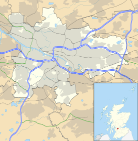
Carntyne
Carntyne
| |
|---|---|
 Carntyne Carntyne shown within Glasgow | |
| Population | 2,400 (2012 census) |
| OS grid reference | NS631652 |
| • Edinburgh | 44.7 miles |
| • London | 400.0 miles |
| Council area | |
| Lieutenancy area |
|
| Country | Scotland |
| Sovereign state | United Kingdom |
| Post town | GLASGOW |
| Postcode district | G32 |
| Dialling code | 0141 |
| Police | Scottish |
| Fire | Scottish |
| Ambulance | Scottish |
| EU Parliament | Scotland |
| UK Parliament | |
| Scottish Parliament | |
Carntyne (Scottish Gaelic: Càrn an Teine) is a district in the Scottish city of Glasgow. It is situated north of the River Clyde, and to the east end of the city. Carntyne may have derived its name from the Southern Picto-Scot Settlement of Cairn-ton, however Carntyne may be "fire cairn", from Càrn an Teine in the Gaelic, given the abundance of coal in the area.
The colliery was closed in 1875 and houses were built in the 1930s. The district is traditionally split into High and Lower Carntyne and has a largely ageing population. It is served by many amenities.
Mining
The Carntyne estate had long been celebrated for its almost inexhaustible seams of coal. These had been wrought by the Grays, from generation to generation, since about the year 1600. The Carntyne, or better known as "The Westmuir," Coalpits long afforded one of the chief sources of fuel-supply to Glasgow. In olden time, when people sought to illustrate profundity, they used to cite a then common expression – "As deep as Carntyne Heugh."
The first steam engine used in the West of Scotland for draining water from coal mines was erected at Carntyne in 1768. Previous to its erection, the water was for some time drawn off by the agency of a windmill, until it was blown to pieces in a great storm, long popularly described as "the Windy Saturday." In 1875, the colliery was finally abandoned, partly from the increase of water, partly from the increase of feuing.
Housing estate
The housing scheme which is now known as Carntyne was built during the inter-war years to provide more housing for the overcrowded population of inner Glasgow. At the time, it was at Glasgow's most easterly point and was built around the A8 to Edinburgh, and therefore the streets are named after places in Edinburgh: Marfield Street, Haymarket Street, Inverleith Street etc., with the exception of Carntyne Road and Carntyne Hall Road, the latter referring to the large house which stood in the centre of the district.
Upper Carntyne is one of the more affluent areas in the East End of Glasgow. Marfield Street runs through Carntyne and is suburban and leafy in nature.
Transport
The area is served by Carntyne railway station which provides links to Glasgow City Centre every 15 minutes. First Bus also operate frequent services, including the 41, 43, and 46 routes offering regular access to the City Centre, Easterhouse, Parkhead, and Castlemilk.
Religion
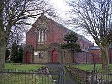
In January 2016, South Carntyne Church closed, and the Congregation amalgamated with High Carntyne to form what is now called Carntyne Parish Church. The South Carntyne building has since been bought by another denomination.
There are three churches: Carntyne Church in the north (Church of Scotland), an Ethiopian Orthodox Church in the South (previously South Carntyne), and St Bernadette's Church on Carntyne Road (Roman Catholic) situated opposite the north exit of Rigby Street.
Education
It is served by Carntyne Primary School, in the north-east area.
St Andrew's Secondary, one of the main Roman Catholic schools serving the East End (along with St Mungo's Academy) is located in Carntyne, near to Springboig.