Croftfoot
Croftfoot
| |
|---|---|
 Croftfoot and Castlemilk viewed from Croftfoot railway station | |
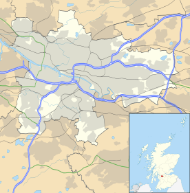 Croftfoot Croftfoot shown within Glasgow | |
| Population | 6,000 |
| OS grid reference | NS601601 |
| Council area | |
| Lieutenancy area |
|
| Country | Scotland |
| Sovereign state | United Kingdom |
| Post town | GLASGOW |
| Postcode district | G44 |
| Dialling code | 0141 |
| Police | Scottish |
| Fire | Scottish |
| Ambulance | Scottish |
| EU Parliament | Scotland |
| UK Parliament | |
| Scottish Parliament | |
Croftfoot (Scots: Croaftfuit, Scottish Gaelic: Bun a' Chroit)[1] is a residential district on the southeastern side of the Scottish city of Glasgow.
Croftfoot is bordered by Castlemilk to the south and King's Park (both the public park and the residential district) to the west within Glasgow, and by the Rutherglen districts of Spittal to the east and Bankhead to the north (across a railway line). It is named after an old steading which was situated at the eastern end of the present day Croftfoot Road, where the Castlemilk Burn now enters a culvert downstream from the site of Castlemilk House.
In addition to shops and amenities, the housing stock largely comprises cottage flats constructed in the 1930s by MacTaggart & Mickel[2] and rented out by the Western Heritable Investment Co. Ltd. The houses went up for sale from the mid fifties and many have since been upgraded internally and externally.
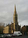
The area is served by Croftfoot railway station and the 5 and 75 First Glasgow bus routes. There is also a large Church of Scotland church in the centre of the district, directly across the road from the local primary school. The primary school was a Protestant school in the 1950s and early 60s before the Glasgow school system became non denominational.
In 2016, the area's recreation fields, which had been allowed to fall into disrepair over a number of years, were subject to planning applications for new housing.[3]
References
- ↑ List of railway station names in English, Scots and Gaelic – NewsNetScotland Archived 22 January 2013 at the Wayback Machine.
- ↑ "Kings Park, Glasgow - origins & history". Glasgow's South Side. Retrieved 13 February 2018.
- ↑ Plans for housing development on former Rutherglen/Croftfoot football parks move a step closer (Daily Record, 2016)
External links
| Wikimedia Commons has media related to Croftfoot. |
- Croftfoot profile at Understanding Glasgow