Rutherglen
Rutherglen
| |
|---|---|
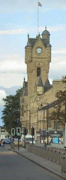
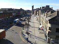 Main Street, the main shopping area of Rutherglen | |
| Population | 25,000 |
| OS grid reference | NS614616 |
| Lieutenancy area | |
| Country | Scotland |
| Sovereign state | United Kingdom |
| Post town | GLASGOW[1] |
| Postcode district | G73 |
| Dialling code | 0141 |
| Police | Scottish |
| Fire | Scottish |
| Ambulance | Scottish |
| EU Parliament | Scotland |
| UK Parliament | |
| Scottish Parliament | |

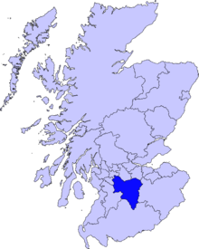
Rutherglen (Scots: Ruglen) is a town in South Lanarkshire, Scotland. Having existed as a Lanarkshire burgh in its own right for more than 800 years, in 1975 it lost its own local council and administratively became a component of the City of Glasgow District Council within the Strathclyde region (along with neighbouring Cambuslang). In 1996 Rutherglen was reallocated to the South Lanarkshire council area.
History
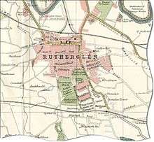
Rutherglen received the status of Royal Burgh in 1126 by Royal Charter from King David I of Scotland who ruled from 1124 to 1153. In the 14th century Walter Stewart, father of King Robert II, was granted Farme Castle. This was located close to Farme Cross in the east of Rutherglen, and stood until the 1960s.
Rutherglen was a centre of heavy industry,[2] having a long coal mining tradition which died out by 1950. J&J White's Chemical Works (later ACC Chrome & Chemicals) in Shawfield, which was in existence from 1820 to 1967, produced more than 70 per cent of the UK's chromate products including chromic acid, chromic oxide pigment, sodium and potassium chromate and dichromate. Today there is a significant legacy of soluble chromium (VI) waste in the area. Rutherglen, and most of the other towns encircling the city, are dormitory suburbs of Glasgow.
Etymology
The name of Rutherglen, as well as its Scots name Ruglen,[3] is perhaps from Scottish Gaelic An Ruadh-Ghleann, meaning 'the red valley'. The derivation may also however be Welsh, or Cumbric and mean "the valley of Rydderch". Rydderch - pronounced 'rutherch' - 'ruther' as in 'brother' and 'ch' as in 'loch' - was one of the most famous kings associated with the Welsh-speaking kingdom which centred on Dumbarton.[4]
Governance
Westminster
Rutherglen was a parliamentary burgh represented in the UK Parliament as a component of Glasgow Burghs constituency from 1708 to 1832, and as a component of Kilmarnock Burghs from 1832 to 1918. In 1918, the Rutherglen constituency was created, which became Glasgow Rutherglen in 1983. In 2005, Scottish constituencies for the UK parliament were mostly replaced with new constituencies, and Rutherglen is now within the Rutherglen and Hamilton West constituency.
Following the 2017 election, Gerard Killen is the local MP,[5][6] replacing Margaret Ferrier of the Scottish National Party who had won in 2015.[7][8]
Holyrood
In 1999, the Scottish Parliamentary constituency of Glasgow Rutherglen was created, with the same boundaries as the then UK parliamentary constituency. In 2011 The constituency was redrawn and renamed simply Rutherglen (although it also encompasses Cambuslang). Following the 2016 elections, Clare Haughey (SNP) is the MSP for Rutherglen. The defeated incumbent James Kelly (Labour) was elected as a list MSP for the Glasgow region which includes Rutherglen.[9] All local representatives have strong personal ties to the area.
South Lanarkshire Council
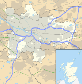
Administratively, the town centre is within the Rutherglen Central and North ward of South Lanarkshire Council,[10][11] which has a population of around 15,000.[12] Including another ward of similar size encompassing the southern parts of the town, its overall population was approximately 30,000 in 2016. With neighbouring Cambuslang's figures being very similar, the many services and amenities shared between the towns must provide for 60,000 residents.
2007 elections
The councillors elected for Rutherglen Wards in the 2007 local elections were:
- Rutherglen South
- Councillor Brian McKenna (Scottish Labour Party)
- Councillor Eileen Baxendale (Scottish Liberal Democrats)
- Councillor Anne Higgins (Scottish National Party)
- Rutherglen Central and North
- Councillor Edward McAvoy (Scottish Labour Party)
- Councillor Gordon Clark (Scottish National Party)
- Councillor Denis McKenna (Scottish Labour Party)
2012 elections
In the 2012 local elections, the following councillors were elected:
- Rutherglen South
- Councillor Brian McKenna (Scottish Labour Party)
- Councillor Robert Brown (Scottish Liberal Democrats)
- Councillor Anne Higgins (Scottish National Party)
- Councillor Anne Higgins subsequently died on 20 November 2012 and a by-election was held on 14 February 2013. This was won by Ged Killen (Scottish Labour Party).[13]
- Rutherglen Central and North
- Councillor Edward McAvoy (Scottish Labour Party)
- Councillor Gordon Clark (Scottish National Party)
- Councillor Denis McKenna (Scottish Labour Party)
2017 elections
In the 2017 local elections, the following councillors were elected:[14]
- Rutherglen South
- Councillor Carol Nugent (Scottish National Party)
- Councillor Robert Brown (Scottish Liberal Democrats)
- Councillor Margaret Cowie (Scottish Labour Party)
- Rutherglen Central and North
- Councillor Janine Calikes (Scottish National Party)
- Councillor Ged Killen (Scottish Labour Party)
- Councillor Jared Wark (Scottish Conservative and Unionist Party)
- Ged Killen subsequently became Westminster MP for the area. A by-election was held on 23 November 2017, won by Martin Lennon (Scottish Labour Party).[15]
Transport
Rutherglen Main Street is served by Rutherglen railway station and there are also numerous bus links into Glasgow City Centre. Completion of the M74 Extension means that there is a motorway going through the town, that will allow easier access to places such as Glasgow Airport and the English Border.
Media
The local newspaper is the Rutherglen Reformer.
The local community radio station is CamGlen Radio.
Areas in the Royal Burgh of Rutherglen
The Royal Burgh of Rutherglen has expanded over the years and now contains many other areas.
Since being granted Royal Burgh status by King David I, the town has grown from strength to strength and increased in size. It now covers a much larger region than the initial Burgh boundary. The nearby village of Burnside and High Burnside fall under the Rutherglen boundary but have their own Community Council. Historic areas such as the Burgh, Farme Cross, Quigleys and Burnside have changed greatly over the years too and more recent estates like Westhouse and the post-war developments of Newfield and Burnhill have given the Burgh an ever-changing character.
The current area of Rutherglen can be divided into 22 areas (seven of which fall into the Burnside and High Burnside area of the Burgh which was once, and is often still considered to be, self-contained).
Burgh
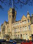
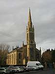
The Burgh area of Rutherglen includes the old heart of the Royal Burgh of Rutherglen and the area directly around it. It features a war memorial, several religious establishments, old school house, new restaurants, a statue of Dr. Gorman, old county buildings, old tenements.
The Mitchell Arcade was given a makeover and renamed the Rutherglen Shopping Centre and used to feature a Daily Market. The Town Hall was recently refurbished as well.
Farme Cross
Farme Cross is one of the Boundary Areas of the Royal Burgh and is surrounded by the River Clyde and the City of Glasgow (Dalmarnock). There is a great many monuments and attractions here including a series of Standing Stones to commemorate the boundary stones of the old Royal Burgh and another monument near the bridge to Dalmarnock in Glasgow.
There is a lot of development work proposed for this region following the completion of the M74 Extension to the Glasgow Region Motorway network and the Clyde Gateway developments.[16][17][18] A new retail park around the supermarket features two fast-food restaurants, KFC and McDonald's.
Cuningar Loop
The Cuningar Loop is an area on the south of the River Clyde near the Farme Cross district of Rutherglen. It has now been transformed into a woodland park[19] connecting across the River Clyde to the City of Glasgow (Dalmarnock) and the Commonwealth Games village.
Shawfield
The Shawfield region of the Royal Burgh of Rutherglen is mostly abandoned business districts. The Clyde Gateway projects aims to reinvest in this region and create new business parks and make the River Clyde accessible in Rutherglen once again. The old port of Rutherglen is accessible where the railway line passes over the riverside path. This area is however overgrown. You can access Farme Cross from under the railway bridge via the undergrowth.
Currently Shawfield Stadium (the former home of Clyde FC) is home to dog racing. Although not immediately noticeable, the building has Art Deco features.
Burnhill
Burnhill in the West of the Royal Burgh of Rutherglen borders the City of Glasgow (Toryglen and Hangingshaw). The region is home to the Rutherglen Branch of the South Lanarkshire Council youth club, Universal Connections and also The Celsius Stadium for Rutherglen football club, Glencairn. The area heavily features grassland, especially around the grass mound of Burnhill itself where the Jenny Burn from Cathkin Braes and Castlemilk (Glasgow) passes underneath.
Newfield
Lying adjacent to Burnhill, Newfield is a small estate bordering Bankhead (Rutherglen) and Croftfoot (Glasgow). There are limited amenities on the border with the Glasgow region including a pub and small grassed areas are dotted around between the housing.
Westhouse
Falling almost entirely within the Newfield and Bankhead areas is a new estate of Newhouse. This area features modern, attractive housing developments and keeps the green theme from Glasgow and Rutherglen with gardens throughout.
Clincarthill
Lying immediately behind the Burgh area, Clincarthill rises high over Rutherglen offering views across the Royal Burgh. There is a church and a school in this area and plenty of remaining old sandstone tenements from the past. The area has a distinctive character of its own.
Wardlawhill
Lying across Stonelaw Road from Clincarthill, Wardlawhill and its twin act like sentinels guarding the entrance and exit from Burgh (Rutherglen) to Burnside Village and Stonelaw beyond. There are a few remaining tenement buildings here as well as a church. The area features some older, large housing and is a gateway to the Stonelaw region featuring the old Rutherglen Academy which later became Stonelaw High.
Overtoun
The area including and surrounding Overtoun Park features a number of old buildings, including a nearby set of old red sandstone tenement buildings. The fountain in the park was once in Rutherglen Main Street. It had been erected in 1897 to mark Queen Victoria's Diamond Jubilee but was moved to the park in 1911 as it had become an obstacle to the increasingly popular motor car. The park was briefly one of the City of Glasgow District Parks when Rutherglen was under Glasgow Rule from 1975 to 1996.
Gallowflat
The area known locally as East Main Street featuring some old tenement buildings. There is also an ancient burial mound which had been used at one time as an icehouse in the grounds of the now demolished Gallowflat house.
Stonelaw
South of Gallowflat you reach Stonelaw, an area including Stonelaw High School and Rutherglen bowling club. This region has many features of the Garden Suburb including Woodburn Park a valley-like park on the East of Stonelaw Road which takes its name from the now-demolished Woodburn House. The most up-market place in Rutherglen, it is home to many expensive properties. The house system of Stonelaw High School names are based from avenues in the Stonelaw Area Jedburgh, Dryburgh,Melrose and Kelso
Bankhead
With a burn flowing through it and some old tenement buildings. There is a small row of shops here also.
Quigleys Estate
Once a private estate, the land of Quigleys is now a housing scheme - albeit a small one. The burn that flows through most of this side of Rutherglen is visible here for some distance ending in a small pond near the Bankhead estate. The grassland and pathway here are popular with local residents.
Burnside and High Burnside
A small prosperous village within the Rutherglen boundary, centred mostly around the Stonelaw Road and Burnside Road areas. It is a pleasant leafy suburb approximately six miles from the heart of Glasgow with its own set of shops and a small parkland, namely, Stonelaw Woods and Woodburn Park. It is also home to a supermarket (off Stonelaw Road) and hotel (off East Kilbride Road). There are a number of churches and a bowling green, and several tennis courts. Much of the traditional residential property was built in the early 1900s from blond and red sandstone providing a pleasant, traditional environment for families.
Burnside
Burnside itself contains the main shopping area and some older housing. Stonelaw Woods lies at the northern boundary of the village and takes its name from the old Stonelaw Tower (a form of castle) that once stood nearby Burnside and the Stonelaw area of Rutherglen. The nearby Woodburn Park offer local residents many green spaces to visit.
High Burnside
High Burnside is a region to the south of Burnside which includes nearly all of the more modern estates mentioned below. As such the elements of High Burnside that remain are mostly the streets of older houses off of Burnside Road north of Blairbeth Road (including several with great views over the Burgh of Rutherglen and the City of Glasgow) and those off the Cathkin Bypass and at the far side of the Cathkin Estate. A small park sits at the heart of High Burnside with amenities for children.
High Crosshill
A small region featuring some old houses and bordering the Burnside area of the Royal Burgh. It gives access to Overtoun Park, has some views on Broomieknowe Road and includes Rutherglen Cemetery.
Springhall
A self-contained estate featuring a few local landmarks such as a sports court and the Cathkin Library.There are two local schools (Loch Primary and St AnthonysRC ) and small parts of the estate are built on the land of a former loch (Boultrie Loch) which was a hot-spot for curling and skating in winter. A new stone sign welcomes you into the estate from the East Kilbride Road entrance. There is a small collection of local shops near the library and a sports pitch in a pen at the heart of the estate. A large housing tower block looms over the centre of the estate also.
Cathkin
A modern estate, currently undergoing a great deal of regeneration. The estate borders the City of Glasgow (Carmunnock and Cathkin Braes Country Park) and offers views over the City of Glasgow valley. A small wooded area (Cathkin Woods) near the boundary region with Cambuslang (Whitlawburn) and East Kilbride District. Cathkin Shops off Cathkin Bypass and Cullins Road feature a supermarket, local newsagent, betting shop and more. The old Cathkin House at the top of the estate offers a great view over Rutherglen and Glasgow beyond. Like many parts of the town, a new stone and metal entrance sign welcomes you as you enter Cathkin from Cathkin Bypass.
Fernhill
A modern housing estate undergoing a great deal of regeneration. It is home to an all girl High School and has its own Community Centre. A park was regenerated in the 1990s, Fernhill Park and offers a home to many animals. The area is bordered by the City of Glasgow (Castlemilk). Fernhill Road divides the estate. The Cathkin Relief Road was built in 2016/17 at a cost of £21 million and takes Mill Street from Rutherglen and extended it through the parkland between Fernhill and High Burnside to connect with the Cathkin Bypass. This Resulted in the loss of much parkland and habitat. It split Fernhill from the other areas of Rutherglen. The estate has two churches at either end and an entrance sign off Burnside Road.
Blairbeth
Blairbeth housing estate with some small local amenities and little parks. The area borders Burnside proper and includes several hillside streets with views over the Burgh of Rutherglen and Glasgow. New facilities for local residents have been added to the estate. A large grass field bordering Fernhill Road and Mill Street is popular in the summer months for football. This park land is being reduced in size by the Cathkin Relief Road project which is currently under construction.
Spittal
A small community with a little burn flowing through it (originating somewhere in Cathkin Braes Country Park or Castlemilk Park in the City of Glasgow). A new Community Centre was built some years back. There are also local amenities. The estate borders Croftfoot and Castlemilk in the City of Glasgow. A small grassed area borders the local centre and the burn (popularly known as the Jenny Burn in Castlemilk, Glasgow).
Education
Schools in the Rutherglen area
Non-denominational schools
- Bankhead Primary School, Bankhead Road, Rutherglen, G73 2BQ
- Burgh Primary School, 41 King Street, Rutherglen, G73 1JY
- Burnside Primary School, Glenlui Avenue, Burnside, Rutherglen, G73 4JE
- Calderwood Primary School, Buchanan Drive, Rutherglen
- Rutherglen High School, Reid Street, Rutherglen, G73 3DF
- Spittal Primary School, Lochlea Road, Spittal, Rutherglen
- Stonelaw High School, 140 Calderwood Road, Rutherglen, G73 3BP
- Cathkin Primary School, Burnside Road, Rutherglen, G73 4AA
- Cathkin High School, Langlea Road, G72 8ES
Roman Catholic schools
- St Anthony's Primary School, Lochaber Drive, Rutherglen, G73 5HX
- St Columbkille's Primary School, Clincarthill Road, Rutherglen, G73 2LG
- St Mark's Primary School, Kirkriggs Avenue, Blairbeth, Rutherglen, G73 4LY
- Trinity High School, Glenside Drive, Eastfield, Rutherglen, G73 3LW
Private schools
- Fernhill School, Fernbrae Avenue, Fernhill, Rutherglen, Glasgow, G73 4SG
Sport
Football
Rutherglen has one football club, Rutherglen Glencairn F.C. who play in the Scottish Junior West Region Super Premier League. The club was formed in 1896 and has won the famous Scottish Junior Cup on 4 occasions (1901–02, 1918–19, 1926–27, 1938–39).[20]
Rutherglen Glencairn recently moved into a brand new stadium (New Southcroft Park, currently sponsored by Celsius Cooling and renamed as The Celsius Stadium) situated in the Burnhill area of Rutherglen following the demolition of the old ground (Southcroft Park). The side had played at their old ground for over 100 years. The Glencairn Venue building on Glasgow Road is owned by the football club, although the company operating in the building is a separate entity from the club.
In 2008 Rutherglen Glencairn won the Central District League First Division Championship with a record points total. The 2009/2010 season saw Glencairn record back to back Championships when they won the West Region Super League Division One Championship at the first attempt.
Clyde Football Club used to play in the area before moving to the former new town of Cumbernauld. The immediate area could be considered the cradle of Scottish football, with Hampden Park, the national stadium and home to Scotland's oldest football club Queen's Park F.C. being close by as well as Cathkin Park, the home of the defunct Third Lanark F.C. and not far to the north, Celtic Park, the home of Celtic F.C. - all of which (apart from Clyde's former ground) are located in the City of Glasgow.
Notable people
- Robbie Coltrane, comedian/actor, was born in Rutherglen.
- Marie Cassidy, State Pathologist for Ireland was born in Rutherglen.
- Midge Ure of the band Ultravox went to Rutherglen Academy in Rutherglen.
- Audrey Tait, drummer of hip-hop band Hector Bizerk is also a Ruglonian.
- Alistair MacLean was a teacher at Gallowflat High in Hamilton Road. Television script writer.
- James White (1812-1884) was a lawyer and a partner in J & J White Chemicals. His statue stands in Cathedral Square, Glasgow.
- John Campbell White also known as Baron Overtoun and Lord Overtoun was the son of James White and another high-profile partner in the Whites firm. His successor was his cousin William James Chrystal who is mentioned in a plaque on Main Street for his contributions relating to the building of the current Old Parish Church.[21]
- Actress and comedian Janet Brown, known for her impressions of Margaret Thatcher, was born and bred in Rutherglen.
- Dr James Burn Russell, Chief Medical Officer for Scotland at the turn of the 20th century, lived in Rutherglen for many years [22][23]
- Folk singer Matt McGinn was born in the Calton but lived in Rutherglen for many years and wrote songs which mention Rutherglen, like "Ru'glen Jean" and "Rosy Anna".
- SNP MSP John Mason is from Rutherglen
- Labour House of Lords Life peer Baron Tommy McAvoy.
- Eddie McAvoy, leader of South Lanarkshire Council, brother of Baron Tommy McAvoy.
- Actor and comedian Richard Rankin (born Richard Harris) grew up in Rutherglen with his brother and fellow actor, Colin Harris. Rankin starred in popular TV shows such as Burnistoun and Taggart.
- Actor Scott Kyle grew up in Rutherglen
- Sports TV presenter Dougie Donnelly grew up in Rutherglen.
- Actor, musician and playwright Dave Anderson was raised in the burgh
- Dougie Thomson, the bass guitarist for Supertramp from 1972-1988 is from Rutherglen.
- Statistician William Gemmell Cochran was born in Rutherglen.
Sportspeople
- Footballer Archie Baird, Aberdeen player and World War II POW, was born in Rutherglen and also played for local side Glencairn. His sister, journalist Mamie Baird, married TV broadcaster Magnus Magnusson and their family home was in the town and was where children Jon Magnusson (producer) and TV news presenter Sally Magnusson grew up.
- Bobby Murdoch, Celtic midfielder (one of the Lisbon Lions) came from Rutherglen; in 2016 a plaque and display was unveiled at the Town Hall honouring his achievements.[24] His brother Billy Murdoch played for Kilmarnock.
- Celtic and Scotland forward Jimmy McMenemy (who won 11 league titles and 7 Scottish Cups) and Alec Bennett (who also played for Rangers) were not only born in Rutherglen but learned their skills at Glencairn.
- Rutherglen was the birthplace of Archie Jackson, the Australian cricketer. Another reputable cricket player who grew up in Australia, Thomas Leather was also born in the town prior to emigrating, as was American basketball champion John Moir.
- Collette McCallum, international footballer player for Australia, was born in Rutherglen and emigrated at 4 years old.[25] Other Ruglonian female footballers are Amy McDonald[26] and Brogan Hay.[27]
- Rangers and Scotland defender Colin Jackson was born in Glasgow and raised in Aberdeen but lived in Rutherglen for most of his life.
- The Scottish rugby internationals Duncan Weir and Jonny Gray and British and Irish Lion Richie Gray were also born in Rutherglen and attended school there. Commonwealth Games rugby international Scott Forrest is also from Rutherglen. Weir and Forrest are former players of local Cambuslang Rugby Club.
- Pre-war footballer Peter Roney was born in Rutherglen in 1887. More recently international striker and football manager Steve Archibald was raised in Rutherglen attending Burgh Primary School. At one point in his career he played with Clyde F.C. when the club was located at Shawfield Stadium.
- Andy Walker, another striker who played most notably for Motherwell and Celtic and later became a TV sports presenter, is also a Ruglonian who attended Trinity High. Former Celtic youth defender Stuart Findlay was also educated at Trinity. Other Rutherglen footballers of note include Stephen McKeown and Brian McPhee.
- Dundee United and Partick Thistle midfielder Chris Erskine was born in Rutherglen.
- Pro wrestler and former ICW heavyweight champion Jack Jester is from Rutherglen.
- Several notable persons born between 1973 and 1996 (principally footballers) are also 'from' Rutherglen, although in many cases their link to the town is only tenuous due to Rutherglen being the location of a large regional maternity hospital (now closed) operating between these years; many children born here would have grown up in Glasgow, East Kilbride or elsewhere. This list includes international players Craig Bryson, Steven Hammell and Aiden McGeady. However footballers Bob Davidson, Steven Saunders and Alan Trouten are known to have attended Stonelaw High School.
Landmarks
The local war memorial is by Scots sculptor George Henry Paulin.[28]
See also
References
- ↑ "List of UK post towns". Evox Facilities. Archived from the original on 19 February 2012. Retrieved 2012-02-22.
- ↑ "Rutherglen Lanarkshire". A Vision of Britain through Time. Retrieved 15 August 2018 – via University of Portsmouth.
- ↑ "List of railway station names". Newsnetscotland.com. 2011-08-18. Retrieved 2012-11-16.
- ↑ "Ainmean-Àite na h-Alba - Gaelic Place-Names of Scotland - Database". Gaelicplacenames.org. Retrieved 2012-11-16.
- ↑ Kerr, Aiden (9 June 2017). "Labour gain first Scottish seat from SNP in election". STV Group. Retrieved 11 July 2017.
- ↑ Spooner, Murray (9 June 2017). "Labour takes Rutherglen and Hamilton West". Daily Record / Rutherglen Reformer. Trinity Mirror. Retrieved 11 July 2017.
- ↑ "Election 2015: Rutherglen & Hamilton West". BBC News. 8 May 2015. Retrieved 11 July 2017.
- ↑ Dickie, Douglas (8 May 2015). "Rutherglen and Hamilton West election results: SNP's Margaret Ferrier takes Labour hotspot with 52 per cent of the vote". Daily Record / Rutherglen Reformer. Trinity Mirror. Retrieved 11 July 2017.
- ↑ "Scottish Parliament election 2016 constituency result: Rutherglen". The Scotsman. 6 May 2016. Retrieved 11 July 2017.
- ↑ "Map ward 12 - Rutherglen Central and North" (PDF). South Lanarkshire Council. 4 May 2017. Retrieved 23 July 2018.
- ↑ "Rutherglen Central and North". Police Scotland. Retrieved 23 July 2018.
- ↑ "South Lanarkshire". City Population. 30 June 2016. Retrieved 23 July 2018.
- ↑ Dickie, Douglas (20 February 2013). "Killen wins Rutherglen South for Labour". Daily Record / Rutherglen Reformer. Trinity Mirror. Retrieved 11 July 2017.
- ↑ "Council elections: SNP biggest party in Rutherglen and Cambuslang but Tory success is big talking point". Daily Record / Rutherglen Reformer. 5 May 2017. Retrieved 11 July 2017.
- ↑ "Labour hold Rutherglen Central and North". Daily Record / Rutherglen Reformer. 24 November 2017. Retrieved 18 March 2018.
- ↑ "Two 74". Ashfield Land. Retrieved 11 July 2018.
- ↑ "Green light for £15m mixed use development in South Lanarkshire". Scottish Construction Now. 17 February 2016. Retrieved 11 July 2018.
- ↑ "Rutherglen's Two74 project faces delay". Daily Record / Rutherglen Reformer. 15 September 2016. Retrieved 11 July 2018.
- ↑ Forestry Commission Scotland - Cuningar Loop.
- ↑ "Team Photograph". Freewebs.com. Retrieved 2012-11-16.
- ↑ "Plaque on King Street (actually Queen Street)". Geograph. 12 April 2013. Retrieved 17 June 2017.
- ↑ "Family of eminent doctor appeal for information (Daily Record, 2016)".
- ↑ "James B Russell". theglasgowstory.com. Retrieved 29 May 2016.
- ↑ "Celtic legend Bobby Murdoch honoured at Rutherglen Town Hall". Daily Record. 17 October 2016. Retrieved 16 December 2016.
- ↑ "Collette McCallum plays final game as Australia draw with Scotland". Daily Record. 16 April 2015. Retrieved 19 October 2016.
- ↑ "Scotland call-up for Amy McDonald". Daily Record / Rutherglen Reformer. 4 March 2009. Retrieved 16 June 2017.
- ↑ Spooner, Murray (18 February 2016). "Two Fernhill sisters have been selected for the Scotland Women's training camps". The Daily Record. Retrieved 16 June 2017.
- ↑ A Brief Biography of George Henry Paulin, Air Comm. Marcus Wetherspoon
Bibliography
- Rutherglen Lore by W. Ross Shearer, printed in 1922
External links
| Wikimedia Commons has media related to Rutherglen. |
| Wikivoyage has a travel guide for Rutherglen. |
- Rutherglen Academy historic pictures
- Art of the States: the soadie waste musical work inspired by Rutherglen dance hall