Kent Peninsula
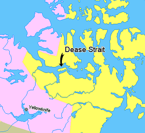
The Kent Peninsula is a large peninsula, almost totally surrounded by water, in Nunavut's northern Canadian Arctic mainland. Were it not for a 5-mile isthmus at the southeast corner it would be a long island parallel to the coast. From the isthmus it extends 105 mi (169 km) westward into the Coronation Gulf. To the south, Melville Sound separates it from the mainland. To the north is Dease Strait and then Victoria Island. To the west is Coronation Gulf and to the east, Queen Maud Gulf. Cape Flinders marks the western tip of the peninsula, Cape Franklin is at the northwestern point, and Cape Alexander marks the northeastern point.[1]
Historically, the Umingmuktogmiut subgroup of the Copper Inuit had a permanent community at Umingmuktog on the peninsula's western coast.[2] A landmark for early explorers was Point Turnagain, located about 25 miles northeast of Cape Flinders, near Cape Franklin at about 68°36′30″N 108°18′30″W / 68.60833°N 108.30833°W. In 1821, John Franklin reached the point from the west and then turned back. In 1838, Thomas Simpson nearly reached the same point, but was blocked by ice and had to walk 100 miles east. In 1839, the coast was clear of ice and Simpson followed the entire coast eastward.
References
- ↑ McGoogan, Ken (2003). Fatal Passage: The Story of John Rae, the Arctic Hero Time Forgot. Basic Books. p. 139. ISBN 0-7867-1156-6.
- ↑ Stefansson, Vilhjalmur (1914). The Stefánsson-Anderson Arctic Expedition of the American Museum: Preliminary Ethnological Report. New York: The Trustees of the American Museum. p. 28. OCLC 13626409.
Coordinates: 68°30′N 107°00′W / 68.500°N 107.000°W