Rankin Inlet
| Rankin Inlet Kangiqliniq ᑲᖏᕿᓂᖅ | |
|---|---|
 | |
 Rankin Inlet  Rankin Inlet | |
| Coordinates: 62°48′35″N 092°05′58″W / 62.80972°N 92.09944°WCoordinates: 62°48′35″N 092°05′58″W / 62.80972°N 92.09944°W | |
| Country | Canada |
| Territory | Nunavut |
| Region | Kivalliq Region |
| Electoral districts |
Rankin Inlet North-Chesterfield Inlet Rankin Inlet South |
| Government[1][2][3] | |
| • Type | Hamlet Council |
| • Mayor | Robert Janes |
| • MLAs |
Cathy Towtongie Lorne Kusugak |
| Area[4] | |
| • Total | 20.24 km2 (7.81 sq mi) |
| • Population Centre | 2.59 km2 (1.00 sq mi) |
| Elevation[5] | 28 m (92 ft) |
| Population (2016)[4][6] | |
| • Total | 2,842 |
| • Density | 140/km2 (360/sq mi) |
| • Population Centre | 2,441 |
| • Population Centre density | 940/km2 (2,400/sq mi) |
| Time zone | UTC-6 (CST) |
| • Summer (DST) | UTC-5 (CDT) |
| Canadian Postal code | X0C 0G0 |
| Area code(s) | 867 |
| Telephone Exchange | 645 |
| GNBC Code | OANSI |
| NTS Map | 055K16 |
| Waterway | Hudson Bay |
| Website | www.rankininlet.net |
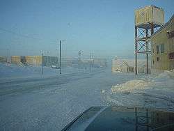
Rankin Inlet (Inuktitut: Kangiqliniq;[7] Inuktitut syllabics: ᑲᖏᕿᓂᖅ[8] or Kangirliniq,[9] ᑲᖏᖅᖠᓂᖅ,[8] or Kangir&iniq[10] meaning deep bay/inlet) is an Inuit hamlet on Kudlulik Peninsula in Nunavut, Canada.[11] Located on the northwestern Hudson Bay, between Chesterfield Inlet and Arviat, it is the regional centre for the Kivalliq Region.
In the 1995 Nunavut capital plebiscite, Iqaluit defeated Rankin Inlet to become territorial capital of Nunavut.
History
Archaeological sites established the area was inhabited around 1200 A.D. by Thule people, bowhead whale hunters. By the late 18th century, they were succeeded by Caribou Inuit who hunted the inland barren-ground caribou, and fished for Arctic char along the coast, as well as the Diane River and Meliadine River. The Hudson's Bay Company established itself throughout the bay in the 17th century, and after 1717, sloops from Churchill, Manitoba traded north to Rankin Inlet and beyond. There was an unfortunate expedition shipwrecked on Marble Island, 32 km east of Rankin Inlet: James Knight's expedition died in the island around 1722. It was surveyed by William Moor in 1747. HBC contact was followed in the mid-19th century by American and European whalers, who were followed by fur traders trapping white fox skins in the early 20th century, followed by missionaries who brought a written language system.[12][13]
The town itself was founded by the owners of the Rankin Inlet Mine, just north of Johnston Cove. Starting in 1957, the mine produced nickel and copper ores from an underground operation. The mine was the first case of Inuit miners in Canada. When the mine closed in 1962, Rankin Inlet had a population of approximately 500 Inuit, and 70-80% had been mine workers. Several unsuccessful attempts followed to develop alternate sources of income for the town. These included a pig ranch in 1969 and a chicken-raising venture in the 1970s. Both animal groups were fed a diet of local fish, which gave the meat an unpleasant flavour. It was also common for the animals to freeze to death or be eaten by polar bears.[14]
Demographics
In the 2016 Census, Statistics Canada reported that Rankin Inlet had a population of 2,842 living in 795 of its 975 total dwellings, a 10.3% increase from its 2011 Census of 2,577.[4] With a land area of 20.24 km2 (7.81 sq mi), it had a population density of 140.4/km2 (363.7/sq mi) in 2016.[4]
Arts and culture
Rankin Inlet is not only notable for its artists and artisans, it is recognized as housing the only Inuit fine-arts ceramics production facility in the world.[15] Community artists work in a variety of media including ceramics, prints, bronze castings, carvings, watercolour and drawing. The Matchbox Gallery, founded in 1987, showcases art work and provides educational resources.
The community is served by Kivalliq News, a weekly newspaper which publishes in both English and Inuktitut.
Services
The community is served by the Rankin Inlet Airport, and by annual supply sealift. Groceries and household goods can be purchased at The North West Company's Northern Store or at the Kissarvik Cooperative.
There are two convenience stores, one being The Red Top Variety Shop, formally the Innukshuk Shop, and the other being Kativik True Value Hardware. Both are locally owned and operated.
There are several places to dine out which include The Captain's Galley (which is in the Siniktarvik Hotel), Turrarvik Inns North (Kissarvik Cooperative) and three Tim Hortons (in the Northern Store and two convenience stores)[16] outlets.
Broadband communications
The community has been served by the Qiniq network since 2005. Qiniq is a fixed wireless service to homes and businesses, connecting to the outside world via a satellite backbone. The Qiniq network is designed and operated by SSI Micro. In 2017, the network was upgraded to 4G LTE technology, and 2G-GSM for mobile voice.
Lodging
Rankin Inlet has several hotels, including the Siniktarvik Hotel[17] and Katimavik Suites.[18]
Geography
Rankin Inlet is notable for the chilling wind, severe winter storms, and water resources. The Diana River empties from the north into the hamlet's namesake inlet. The small Kivalliq Region has several lakes, the largest being Nipissa Lake, and is flanked by two bays, Melvin Bay on the west and Prairie Bay on the east. Paniqtoq Peninsula, on the inlet's far western shore, provides a barrier shelter for the smaller Kivaliq Region. Dozens of islands dot the inlet, including Thomson Island, the largest, and the Barrier Islands, the longest chain. These natural resources attract tourists who hunt, fish, and canoe. The Iqalugaarjuup Nunanga Territorial Park, 10 km (6.2 mi) northwest of Rankin Inlet, is notable for hiking, fishing, bird watching and Thule archaeological sites.[19][20]
Climate
Rankin Inlet has a subarctic climate (Köppen climate classification Dfc), just short of a tundra climate. It is above the tree line. Temperatures stay below freezing from late September to early June. Although the climate is subarctic, temperatures rise and fall too rapidly and do not stay above 10 °C or 50 °F for long enough (30 days) for trees to grow. Under the alternate formula for determining the boundary between arctic and subarctic climates posited by Otto Nordenskiöld, however, Rankin Inlet, along with Arviat and Baker Lake, qualify as arctic based on the relationship between the temperatures of the coldest and warmest months; in the case of Rankin Inlet, with a coldest-month (January) mean of −30.8 °C or −23.4 °F, said boundary for the warmest month would be 12.1 °C or 53.8 °F and Rankin Inlet’s warmest month (July) averages only 10.5 °C or 50.9 °F.
Beginning on January 16, 2008, Rankin Inlet endured the longest recorded blizzard in Canada.[21] Wind speed was 74 km/h (46 mph) or above, with gusts to 90 km/h (56 mph), and wind chill values were as low as −58 °C or −72.4 °F. This blizzard lasted 7 days 5 hours.[22]
| Climate data for Rankin Inlet Airport | |||||||||||||
|---|---|---|---|---|---|---|---|---|---|---|---|---|---|
| Month | Jan | Feb | Mar | Apr | May | Jun | Jul | Aug | Sep | Oct | Nov | Dec | Year |
| Record high humidex | −3.0 | −4.4 | 1.1 | 2.5 | 13.4 | 26.3 | 32.2 | 31.8 | 21.8 | 11.7 | 1.4 | 0.8 | 32.2 |
| Record high °C (°F) | −2.5 (27.5) |
−4.4 (24.1) |
1.3 (34.3) |
3.4 (38.1) |
14.1 (57.4) |
26.1 (79) |
28.9 (84) |
30.5 (86.9) |
20.6 (69.1) |
11.8 (53.2) |
1.5 (34.7) |
0.9 (33.6) |
30.5 (86.9) |
| Average high °C (°F) | −27.3 (−17.1) |
−26.1 (−15) |
−20.6 (−5.1) |
−11.1 (12) |
−2.4 (27.7) |
7.9 (46.2) |
14.9 (58.8) |
13.1 (55.6) |
6.3 (43.3) |
−1.9 (28.6) |
−13.0 (8.6) |
−21.9 (−7.4) |
−6.9 (19.6) |
| Daily mean °C (°F) | −30.8 (−23.4) |
−29.9 (−21.8) |
−25.0 (−13) |
−15.6 (3.9) |
−5.8 (21.6) |
4.2 (39.6) |
10.5 (50.9) |
9.7 (49.5) |
3.8 (38.8) |
−4.6 (23.7) |
−17.0 (1.4) |
−25.7 (−14.3) |
−10.5 (13.1) |
| Average low °C (°F) | −34.4 (−29.9) |
−33.6 (−28.5) |
−29.2 (−20.6) |
−20.1 (−4.2) |
−9.0 (15.8) |
0.5 (32.9) |
6.1 (43) |
6.2 (43.2) |
1.3 (34.3) |
−7.3 (18.9) |
−20.9 (−5.6) |
−29.4 (−20.9) |
−14.2 (6.4) |
| Record low °C (°F) | −46.1 (−51) |
−49.8 (−57.6) |
−43.4 (−46.1) |
−35.7 (−32.3) |
−23.8 (−10.8) |
−9.4 (15.1) |
−1.9 (28.6) |
−1.4 (29.5) |
−9.0 (15.8) |
−27.4 (−17.3) |
−36.5 (−33.7) |
−43.6 (−46.5) |
−49.8 (−57.6) |
| Record low wind chill | −66.8 | −70.5 | −64.4 | −53.6 | −35.9 | −17.6 | −5.3 | −8.8 | −18.1 | −42.7 | −55.3 | −62.4 | −70.5 |
| Average precipitation mm (inches) | 8.7 (0.343) |
8.2 (0.323) |
12.3 (0.484) |
19.9 (0.783) |
19.5 (0.768) |
26.6 (1.047) |
42.0 (1.654) |
57.4 (2.26) |
42.9 (1.689) |
38.0 (1.496) |
21.7 (0.854) |
12.8 (0.504) |
310.1 (12.209) |
| Average rainfall mm (inches) | 0.0 (0) |
0.0 (0) |
0.0 (0) |
1.1 (0.043) |
7.0 (0.276) |
22.1 (0.87) |
41.9 (1.65) |
57.2 (2.252) |
39.1 (1.539) |
12.9 (0.508) |
0.3 (0.012) |
0.1 (0.004) |
181.8 (7.157) |
| Average snowfall cm (inches) | 8.9 (3.5) |
8.5 (3.35) |
12.5 (4.92) |
19.2 (7.56) |
13.0 (5.12) |
4.6 (1.81) |
0.1 (0.04) |
0.2 (0.08) |
3.8 (1.5) |
25.5 (10.04) |
22.4 (8.82) |
13.3 (5.24) |
131.9 (51.93) |
| Average precipitation days (≥ 0.2 mm) | 7.8 | 6.6 | 9.0 | 8.5 | 8.7 | 7.7 | 10.4 | 13.2 | 12.7 | 14.9 | 12.6 | 10.0 | 122.1 |
| Average rainy days (≥ 0.2 mm) | 0.0 | 0.0 | 0.0 | 0.7 | 2.3 | 6.3 | 10.4 | 13.2 | 10.5 | 4.2 | 0.4 | 0.1 | 48.4 |
| Average snowy days (≥ 0.2 cm) | 7.8 | 6.7 | 9.0 | 8.2 | 7.1 | 2.0 | 0.1 | 0.1 | 3.3 | 12.4 | 12.5 | 10.0 | 79.3 |
| Average relative humidity (%) | 66.2 | 67.3 | 71.3 | 79.0 | 82.3 | 72.3 | 66.6 | 70.6 | 76.3 | 84.5 | 78.4 | 70.2 | 73.7 |
| Source: Environment Canada Canadian Climate Normals 1981–2010[23] | |||||||||||||
Notable people
_Thule-Site_1995-06-22.jpg)
See also
References
- ↑ Nunavummiut vie for council positions in upcoming hamlet elections
- ↑ Results for the constituency of Rankin Inlet North-Chesterfield Inlet Archived 2013-11-14 at the Wayback Machine. at Elections Nunavut
- ↑ "Results for the constituency of Rankin Inlet South". Archived from the original on 2016-04-04. Retrieved 2017-01-11.
- 1 2 3 4 "Census Profile, 2016 Census". Statistics Canada. Retrieved February 18, 2017.
- ↑ Elevation at airport. Canada Flight Supplement. Effective 0901Z 19 July 2018 to 0901Z 13 September 2018.
- ↑ "Census Profile, 2016 Census Rankin Inlet [Population centre], Nunavut and Keewatin, Region [Census division], Nunavut". Statistics Canada. Retrieved 2017-02-18.
- ↑ Rankin Inlet
- 1 2 Research Database
- ↑ "Harvest Estimates" (PDF). Archived from the original (PDF) on 2012-04-25. Retrieved 2011-11-07.
- ↑ 'Language watchdog needed in Nunavut
- ↑ nkin Inlet at the Atlas of Canada
- ↑ "NOTRE DAME DU CAP". arcicomi.ca. Archived from the original on 2003-05-03. Retrieved 2008-01-26.
- ↑ "Pulaarvik Kablu Friendship Centre". pulaarvik.ca. Retrieved 2008-01-26.
- ↑ History of the Development of Agriculture in the N.W.T. Archived 2007-09-29 at the Wayback Machine.
- ↑ Rankin Inlet art and artists Archived 2007-10-22 at the Wayback Machine.
- ↑ Tim Hortons hype out of line, says Nunavut restaurant-owner
- ↑ Siniktarvik Hotel
- ↑ Katimavik Suites
- ↑ "Landmarks". worldviewtravel.com. Archived from the original on 2007-11-05. Retrieved 2008-01-26.
- ↑ "Iqalugaarjuup Nunanga Territorial Park". Nunavut Parks. Archived from the original on 2007-06-08. Retrieved 2008-01-26.
- ↑ Environment Canada defines a blizzard as a snowstorm with sustained wind speed above 40 km/h (25 mph), visibility below 400 m (1,300 ft) and conditions will last for at least six hours. Blizzard
- ↑ "Home of the blizzard". up here. Oct–Nov 2008. Archived from the original on 2011-09-01. Retrieved 2011-09-17.
- ↑ "Rankin Inlet A" (CSV (4222 KB)). Canadian Climate Normals 1981–2010. Environment Canada. Climate ID: 2303401. Retrieved 2013-11-27.
Further reading
- England JI. 1998. "Rankin Inlet Birthing Project: Outcome of Primipara Deliveries". International Journal of Circumpolar Health. 57: 113-5.
- Igalaaq The Rankin Inlet Community Access Centre. Ottawa, Ont: Caledon Institute of Social Policy, 1999. ISBN 1-894159-30-6
- Jansen, William Hugh. Eskimo Economics An Aspect of Culture Change at Rankin Inlet. Mercury series. Ottawa: National Museums of Canada, 1979.
- Mallon, S. T. Inuktitut, Rankin Inlet Version. Yellowknife, N.W.T.: Dept. of Education, 1974.
- Shirley, James R., and Darlene Wight. Rankin Inlet Ceramics. Winnipeg: Winnipeg Art Gallery, 2003. ISBN 0-88915-224-1
- Watson, Linvill. Television Among Inuit of Keewatin The Rankin Inlet Experience. Saskatoon, [Sask.]: Institute for Northern Studies, University of Saskatoon, 1977.
- Feeney, Mara. Rankin Inlet. Fiddletown: Gaby Press, 2009. ISBN 978-0-9819319-5-1.
External links
| Wikimedia Commons has media related to Rankin Inlet. |
