Queen Maud Gulf
| Designations | |
|---|---|
| Official name | Queen Maud Gulf |
| Designated | 24 May 1982 |
| Reference no. | 246[1] |
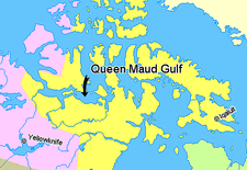
Queen Maud Gulf, Nunavut, Canada.
Nunavut
Northwest Territories
Quebec
Greenland
Queen Maud Gulf (68°20′N 102°00′W / 68.333°N 102.000°WCoordinates: 68°20′N 102°00′W / 68.333°N 102.000°W) lies between the northern coast of the mainland and the southeastern corner of Victoria Island in Nunavut, Canada. At its western end lies Cambridge Bay, leading to Dease Strait; to the east lies Simpson Strait; and to the north, Victoria Strait.
History
In 1839 it was crossed by Peter Warren Dease and Thomas Simpson. It was named by the Norwegian explorer Roald Amundsen in 1905 for the Norwegian queen Maud of Wales.
The wreck of HMS Erebus from Franklin's lost expedition of 1845 to the Northwest Passage was found in 2014. The wreck lies at the bottom of the eastern portion of Queen Maud Gulf, west of O'Reilly Island.[2]
References
- ↑ "Queen Maud Gulf". Ramsar Sites Information Service. Retrieved 25 April 2018.
- ↑ Chase, Steven (9 September 2014). "Finding of Franklin ship fuels Harper's new nationalism". The Globe and Mail. Ottawa. Retrieved 10 September 2014.
This article is issued from
Wikipedia.
The text is licensed under Creative Commons - Attribution - Sharealike.
Additional terms may apply for the media files.