Gjoa Haven
| Gjoa Haven ᐅᖅᓱᖅᑑᖅ Uqsuqtuuq | |
|---|---|
| Hamlet | |
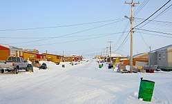 Main street of Gjoa Haven | |
 Gjoa Haven | |
| Coordinates: 68°37′33″N 095°52′30″W / 68.62583°N 95.87500°WCoordinates: 68°37′33″N 095°52′30″W / 68.62583°N 95.87500°W | |
| Country | Canada |
| Territory | Nunavut |
| Region | Kitikmeot Region |
| Electoral district | Gjoa Haven |
| Government[1][2] | |
| • Mayor | Allen Aglukkaq |
| • MLA | Tony Akoak |
| • MP | Hunter Tootoo |
| Area[3][4] | |
| • Total | 28.47 km2 (10.99 sq mi) |
| • Population Centre | 0.78 km2 (0.30 sq mi) |
| Elevation[5] | 47 m (154 ft) |
| Population (2016)[3][4] | |
| • Total | 1,324 |
| • Density | 46.5/km2 (120/sq mi) |
| • Population Centre | 1,197 |
| • Population Centre density | 1,500/km2 (4,000/sq mi) |
| Time zone | UTC-7 (MST) |
| • Summer (DST) | UTC-6 (MDT) |
| Canadian Postal code | X0B 1J0 |
| Area code(s) | 867 |
| Website |
www |
Gjoa Haven (/ˌdʒoʊ
Etymology
The name Gjoa Haven is from the Norwegian Gjøahavn or "Gjøa's Harbour"; it was named by early 20th-century polar explorer Roald Amundsen after his ship Gjøa. This was derived from the old Norse name Gyða, a compressed compound form of Guðfríðr (guð "god" and fríðr "beautiful"').
History
In 1903, the Norwegian explorer Roald Amundsen had entered the area on his ship Gjøa in an expedition intending to travel through the Northwest Passage. By October the straits through which he was travelling began to ice up. Amundsen put Gjøa into a natural harbour on the southeast coast of King William Island. He stayed there, in what Amundsen called "the finest little harbor in the world", for nearly two years. He and his crew spent much of that time with the local Netsilik Inuit, learning from them the skills to live off the land and travel efficiently in the Arctic environment. This knowledge proved to be vital for Amundsen's later successful exploration to the South Pole. He explored the Boothia Peninsula, searching for the exact location of the North Magnetic Pole.
Some Inuit people in Gjøa Haven with European ancestry have claimed to be descendants of Amundsen (or one of his six crew, whose names have not remained as well known). Accounts by members of the expedition told of their relations with Inuit women, and historians have speculated that Amundsen might also have taken a partner,[6] although he wrote a warning against this.[7] Specifically, half brothers Bob Konona and Paul Ikuallaq say that their father Luke Ikuallaq (b. 1904) told them on his deathbed that he was the son of Amundsen. Konona said that their father Ikuallaq was left out on the ice to die after his birth, as his European ancestry made him illegitimate to the Inuit, threatening their community. His Inuit grandparents saved him. In 2012, Y-DNA analysis, with the families' permission, showed that Ikuallaq (and his sons) was not a match to the direct male line of Amundsen.[7] Not all descendants claiming European ancestry have been tested for a match to Amundsen, nor has there been a comparison of Ikuallaq's DNA to that of other European members of Amundsen's crew.[7]
Permanent European-style settlement at Gjoa Haven started in 1927 with a Hudson's Bay Company trading outpost.[8] In 1941 Henry Larsen reached the post from the west. The settlement has attracted the traditionally nomadic Inuit people as they have adapted a more settled lifestyle.
In 1961, the town's population was 110. By 2001, the population was 960 according to the Census, as the Inuit have moved from their traditional camps to be close to the healthcare and educational facilities available at Gjoa Haven. At the 2016 census, the population was 1,324, an increase of 3.5% from the 2011 census.[3] The Population Centre of Gjoa Haven showed 1,197 people living in 0.78 km2 (0.30 sq mi), a decrease of 1.4% from 2011.[4]
Gjoa Haven has expanded to such an extent that a newer subdivision has been developed near the airport at 68°37′56″N 095°52′04″W / 68.63222°N 95.86778°W.
The community is served by the Gjoa Haven Airport and by annual supply sealift. The area is home to CAM-B, a North Warning System site.
Climate
| Climate data for Gjoa Haven Airport | |||||||||||||
|---|---|---|---|---|---|---|---|---|---|---|---|---|---|
| Month | Jan | Feb | Mar | Apr | May | Jun | Jul | Aug | Sep | Oct | Nov | Dec | Year |
| Record high humidex | −7.4 | −11.3 | −6.6 | 0.2 | 2.6 | 19.4 | 26.7 | 23.0 | 16.0 | 4.2 | −1.4 | −1.9 | 26.7 |
| Record high °C (°F) | −6.0 (21.2) |
−11.0 (12.2) |
−5.0 (23) |
1.0 (33.8) |
6.5 (43.7) |
20.8 (69.4) |
24.1 (75.4) |
22.5 (72.5) |
15.4 (59.7) |
4.5 (40.1) |
−0.8 (30.6) |
−8.3 (17.1) |
24.1 (75.4) |
| Average high °C (°F) | −30.4 (−22.7) |
−30.7 (−23.3) |
−25.1 (−13.2) |
−16.0 (3.2) |
−5.9 (21.4) |
4.2 (39.6) |
12.1 (53.8) |
8.9 (48) |
2.1 (35.8) |
−6.7 (19.9) |
−19.0 (−2.2) |
−26.6 (−15.9) |
−11.1 (12) |
| Daily mean °C (°F) | −33.8 (−28.8) |
−34.0 (−29.2) |
−28.9 (−20) |
−20.4 (−4.7) |
−9.4 (15.1) |
1.4 (34.5) |
8.0 (46.4) |
5.8 (42.4) |
0.1 (32.2) |
−9.5 (14.9) |
−22.4 (−8.3) |
−29.9 (−21.8) |
−14.4 (6.1) |
| Average low °C (°F) | −37.1 (−34.8) |
−37.0 (−34.6) |
−32.6 (−26.7) |
−24.8 (−12.6) |
−12.9 (8.8) |
−1.5 (29.3) |
3.8 (38.8) |
2.7 (36.9) |
−2.0 (28.4) |
−12.3 (9.9) |
−25.8 (−14.4) |
−33.1 (−27.6) |
−17.7 (0.1) |
| Record low °C (°F) | −48.3 (−54.9) |
−50.2 (−58.4) |
−46.3 (−51.3) |
−40.0 (−40) |
−28.2 (−18.8) |
−17.0 (1.4) |
−1.1 (30) |
−5.0 (23) |
−14.3 (6.3) |
−32.0 (−25.6) |
−39.4 (−38.9) |
−44.0 (−47.2) |
−50.2 (−58.4) |
| Record low wind chill | −64.2 | −65.3 | −64.5 | −54.0 | −38.1 | −21.9 | 0.0 | −12.9 | −21.2 | −48.1 | −55.0 | −62.5 | −65.3 |
| Average precipitation mm (inches) | 8.3 (0.327) |
7.8 (0.307) |
12.9 (0.508) |
13.5 (0.531) |
15.0 (0.591) |
14.7 (0.579) |
21.2 (0.835) |
28.4 (1.118) |
24.2 (0.953) |
25.0 (0.984) |
11.4 (0.449) |
8.8 (0.346) |
191.0 (7.52) |
| Average rainfall mm (inches) | 0.0 (0) |
0.0 (0) |
0.0 (0) |
0.0 (0) |
1.8 (0.071) |
11.2 (0.441) |
20.8 (0.819) |
27.9 (1.098) |
15.9 (0.626) |
0.9 (0.035) |
0.0 (0) |
0.0 (0) |
78.4 (3.087) |
| Average snowfall cm (inches) | 9.7 (3.82) |
8.8 (3.46) |
15.8 (6.22) |
15.4 (6.06) |
15.2 (5.98) |
3.9 (1.54) |
0.4 (0.16) |
0.5 (0.2) |
8.8 (3.46) |
28.2 (11.1) |
13.4 (5.28) |
10.4 (4.09) |
130.4 (51.34) |
| Average precipitation days (≥ 0.2 mm) | 8.2 | 6.4 | 9.0 | 8.8 | 9.6 | 6.8 | 7.8 | 11.0 | 12.0 | 14.1 | 10.1 | 8.2 | 112.0 |
| Average rainy days (≥ 0.2 mm) | 0.0 | 0.0 | 0.0 | 0.0 | 0.8 | 5.3 | 7.8 | 10.6 | 7.4 | 0.5 | 0.0 | 0.0 | 32.5 |
| Average snowy days (≥ 0.2 cm) | 8.2 | 6.4 | 9.0 | 8.8 | 9.3 | 1.9 | 0.2 | 0.6 | 5.8 | 14.1 | 10.4 | 8.2 | 82.7 |
| Average relative humidity (%) | 62.6 | 63.9 | 70.3 | 77.7 | 85.9 | 81.9 | 70.7 | 75.8 | 82.3 | 87.7 | 76.7 | 66.7 | 75.2 |
| Source: Environment Canada Canadian Climate Normals 1981–2010[9] | |||||||||||||
Attractions
Quqshuun Ilihakvik Centre is a community heritage museum and cultural centre opened in 2013.[10]
- Nattilik Heritage Center- Nattilik artifacts, art, buy and sell art and carvings, museum and local KIA offices
Religion
Two churches are located in the hamlet:
- Immaculate Heart of Mary Roman Catholic Church
- Old Gjoa Haven Church
Government services
Local
- Gjoa Haven RCMP Detachment
- Gjoa Haven Fire Department
- Gjoa Haven Hamlet Council
- Gjoa Haven Continuing Care - a 10-bed, 24/7 health care facility opened in 2010[11]
Territorial
- Gjoa Haven Nunavat Water Board
- Gjoa Haven Lands Administration Office
- Nunavut Social Services Department
- Nunavut Power Corporation
- Nunavut Economic Development Office
Economy
Most employment in Gjoa Haven is with government services; there are a few commercial employers:
- CAP Enterprises Limited - construction and heavy equipment
- Northern Store - retail store
- The Inns North Amundsen Hotel - 16 rooms two storey structure built in 1995
- Qikiqtaq Co-op Limited - retail store
- Gjoa Haven Community Airport Radio Station - operating from Gjoa Haven Airport
The discovery of HMS Terror and HMS Erebus shipwrecks from the Franklin's lost expedition is expected to bring increased tourism to Gjoa Haven, the nearest community to the wreck sites.[12][13]
Education
Gjoa Haven has three schools:
- Quqshuun Ilihakvik Elementary School
- Qiqirtaq Ilihakvik High School
- Nunavut Arctic College
Broadband communications
The community has been served by the Qiniq network since 2005. Qiniq is a fixed wireless service to homes and businesses, connecting to the outside world via a satellite backbone. The Qiniq network is designed and operated by SSI Micro. In 2017, the network was upgraded to 4G LTE technology, and 2G-GSM for mobile voice.
See also
References
- ↑ "Nunatsiaq News 2013-12-03: NEWS: Nunavummiut vie for council positions in upcoming hamlet elections". www.nunatsiaqonline.ca.
- ↑ Results for the constituency of Gjoa Haven Archived 2013-11-14 at the Wayback Machine. at Elections Nunavut
- 1 2 3 "2016 Community Profiles Gjoa Haven". Retrieved 2017-03-05.
- 1 2 3 "2016 Community Profiles Gjoa Haven [Population centre]". Retrieved 2017-03-05.
- ↑ Elevation at airport. Canada Flight Supplement. Effective 0901Z 19 July 2018 to 0901Z 13 September 2018.
- ↑ "Vi er Amundsens etterkommere" Archived 2007-11-04 at the Wayback Machine., Aften Posten
- 1 2 3 "ROALD AMUNDSEN DESCENDANTS IN GJOA HAVEN?" Archived 2013-04-16 at the Wayback Machine., Fram Museum, 27 January 2012
- ↑ Gjoa Haven, The Canadian Encyclopedia
- ↑ "Gjoa Haven A". Canadian Climate Normals 1981–2010. Environment Canada. Climate ID: 2302335. Retrieved 2014-04-30.
- ↑ "Nattilik heritage centre opens its doors, Nunatsiaq Online
- ↑ "Nunavut provides more care closer to home", Nunatsiaq Online
- ↑ "As Franklin's lure brings people North, Gjoa Haven seeks its share of tourism dollars". The Canadian Press. 2017-09-17.
- ↑ Watson, Paul (2015-03-23). "Franklin wreck could help float fortunes of Arctic community". Toronto Star.
Further reading
- Huntford, R. (2003). Scott and Amundsen: The last place on earth. London: Abacus., ISBN 0-349-11395-5
External links
- Official website of the Hamlet of Gjoa Haven
- Aerial photos of Gjoa Haven
- Gjoa Haven, Government of Nunavut
- About Gjoa Haven, Inuit Art/Eskimo Art
| Authority control |
|---|