Taloyoak
| Taloyoak ᑕᓗᕐᔪᐊᖅ Talurjuaq | |
|---|---|
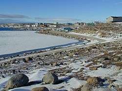 Taloyoak in June | |
 Taloyoak  Taloyoak | |
| Coordinates: 69°32′13″N 093°31′36″W / 69.53694°N 93.52667°WCoordinates: 69°32′13″N 093°31′36″W / 69.53694°N 93.52667°W | |
| Country | Canada |
| Territory | Nunavut |
| Region | Kitikmeot Region |
| Electoral district | Netsilik |
| Government[1][2] | |
| • Type | Hamlet Council |
| • Mayor | Simon Qingnaqtuq |
| • MLA | Emilino Qirngnuq |
| Area[3] | |
| • Total | 37.65 km2 (14.54 sq mi) |
| Elevation[4] | 28 m (92 ft) |
| Population (2016)[3] | |
| • Total | 1,029 |
| • Density | 27/km2 (71/sq mi) |
| Time zone | UTC-7 (MST) |
| • Summer (DST) | UTC-6 (MDT) |
| Canadian Postal code | X0B 1B0 |
| Area code(s) | 867 |
Taloyoak or Talurjuaq (Inuktitut syllabics: ᑕᓗᕐᔪᐊᖅ [taloʁjuˈaq]), formerly known as Spence Bay until 1 July 1992; (2016 population 1,029[3]) is located on the Boothia Peninsula, Kitikmeot, in Canada's Nunavut Territory. The community is served only by air and by annual supply sealift. Taloyoak may mean "large blind", referring to a stone caribou blind or a screen used for caribou hunting. The community is situated 460 km (290 mi) east of the regional centre of Cambridge Bay, 1,224 km (761 mi) northeast of Yellowknife, Northwest Territories. Taloyoak is the northernmost community in mainland Canada.[5]
Broadband communications
The community has been served by the Qiniq network since 2005. Qiniq is a fixed wireless service to homes and businesses, connecting to the outside world via a satellite backbone. The Qiniq network is designed and operated by SSI Micro. In 2017, the network was upgraded to 4G LTE technology, and 2G-GSM for mobile voice.
Demographics
| Year | Population |
|---|---|
| 1981 | 431 |
| 1985 | 452 |
| 1986 | 540 |
| 1988 est. | 540 |
| 1991 | 580 |
| 2006 | 809 |
| 2011 | 899 |
| 2016 | 1,029 |
As of the 2016 census the population was 1,029 an increase of 14.5% from the 2011 census.[3]
Languages spoken are English and Inuktitut.
Surrounding area
Taloyoak is surrounded by tundra and the ground is black/gray. Although, to the north there is an impressive rock formation that looks similar to Ayers Rock.[6]
Climate
| Climate data for Taloyoak Airport | |||||||||||||
|---|---|---|---|---|---|---|---|---|---|---|---|---|---|
| Month | Jan | Feb | Mar | Apr | May | Jun | Jul | Aug | Sep | Oct | Nov | Dec | Year |
| Record high humidex | −8.3 | −11.4 | −5.8 | 0.4 | 4.4 | 20.5 | 24.6 | 22.2 | 12.1 | 4.2 | −2.0 | −1.7 | 24.6 |
| Record high °C (°F) | −8.0 (17.6) |
−11.0 (12.2) |
−3.5 (25.7) |
0.5 (32.9) |
5.0 (41) |
22.0 (71.6) |
24.6 (76.3) |
21.5 (70.7) |
12.9 (55.2) |
4.5 (40.1) |
0.5 (32.9) |
−1.5 (29.3) |
24.6 (76.3) |
| Average high °C (°F) | −30.3 (−22.5) |
−30.1 (−22.2) |
−25.4 (−13.7) |
−15.5 (4.1) |
−5.0 (23) |
5.2 (41.4) |
12.7 (54.9) |
9.5 (49.1) |
2.2 (36) |
−7.2 (19) |
−18.8 (−1.8) |
−25.3 (−13.5) |
−10.7 (12.7) |
| Daily mean °C (°F) | −33.7 (−28.7) |
−33.7 (−28.7) |
−29.5 (−21.1) |
−20.3 (−4.5) |
−9.1 (15.6) |
2.1 (35.8) |
8.4 (47.1) |
6.2 (43.2) |
−0.1 (31.8) |
−10.3 (13.5) |
−22.3 (−8.1) |
−28.9 (−20) |
−14.3 (6.3) |
| Average low °C (°F) | −37.0 (−34.6) |
−37.4 (−35.3) |
−33.6 (−28.5) |
−25.0 (−13) |
−13.1 (8.4) |
−1.1 (30) |
4.0 (39.2) |
2.9 (37.2) |
−2.5 (27.5) |
−13.4 (7.9) |
−25.8 (−14.4) |
−32.5 (−26.5) |
−17.9 (−0.2) |
| Record low °C (°F) | −49.0 (−56.2) |
−49.5 (−57.1) |
−47.0 (−52.6) |
−39.5 (−39.1) |
−29.0 (−20.2) |
−18.5 (−1.3) |
−1.5 (29.3) |
−4.0 (24.8) |
−14.0 (6.8) |
−33.0 (−27.4) |
−40.2 (−40.4) |
−46.0 (−50.8) |
−49.5 (−57.1) |
| Record low wind chill | −66.6 | −68.6 | −66.3 | −56.0 | −36.9 | −20.9 | −3.9 | −10.4 | −22.4 | −50.6 | −53.5 | −60.2 | −68.6 |
| Average precipitation mm (inches) | 8.4 (0.331) |
6.1 (0.24) |
8.6 (0.339) |
9.8 (0.386) |
12.8 (0.504) |
16.7 (0.657) |
23.1 (0.909) |
30.5 (1.201) |
25.6 (1.008) |
22.7 (0.894) |
12.7 (0.5) |
10.6 (0.417) |
187.4 (7.378) |
| Average rainfall mm (inches) | 0.0 (0) |
0.0 (0) |
0.0 (0) |
0.0 (0) |
1.3 (0.051) |
12.7 (0.5) |
22.4 (0.882) |
29.9 (1.177) |
13.9 (0.547) |
0.7 (0.028) |
0.0 (0) |
0.0 (0) |
80.9 (3.185) |
| Average snowfall cm (inches) | 9.3 (3.66) |
6.4 (2.52) |
9.2 (3.62) |
11.6 (4.57) |
12.4 (4.88) |
4.5 (1.77) |
0.7 (0.28) |
0.7 (0.28) |
12.1 (4.76) |
25.8 (10.16) |
14.3 (5.63) |
12.0 (4.72) |
119.0 (46.85) |
| Average precipitation days (≥ 0.2 mm) | 10.1 | 8.9 | 10.6 | 8.8 | 8.9 | 8.5 | 7.6 | 11.0 | 11.0 | 14.5 | 11.3 | 11.1 | 122.3 |
| Average rainy days (≥ 0.2 mm) | 0.0 | 0.0 | 0.0 | 0.0 | 0.5 | 5.8 | 7.5 | 10.7 | 5.1 | 0.5 | 0.0 | 0.0 | 30.0 |
| Average snowy days (≥ 0.2 cm) | 9.7 | 8.3 | 10.2 | 8.3 | 8.3 | 3.5 | 0.1 | 0.4 | 6.4 | 14.1 | 11.2 | 11.0 | 91.5 |
| Average relative humidity (%) | 74.6 | 73.8 | 72.3 | 77.9 | 83.7 | 80.2 | 67.2 | 72.9 | 82.4 | 86.2 | 79.2 | 76.6 | 77.2 |
| Source: Environment Canada Canadian Climate Normals 1981–2010[7] | |||||||||||||
See also
References
- ↑ Nunavummiut elect new municipal leaders
- ↑ Election Results 2013 General Election Archived 2013-11-13 at the Wayback Machine. at Elections Nunavut
- 1 2 3 4 "Census Profile, 2016 Census Taloyoak". Statistics Canada. Retrieved 2017-03-05.
- ↑ Elevation at airport. Canada Flight Supplement. Effective 0901Z 19 July 2018 to 0901Z 13 September 2018.
- ↑ Mark Nuttall (2012). Encyclopedia of the Arctic. Routledge - University of Alberta. p. 269. ISBN 978-1-136-78680-8.
- ↑ ofarim, on August 20, 2008, said: (2008-08-20). "Photo of Ayers Rock of Nunavut". Panoramio. Retrieved 2011-07-26.
- ↑ "Taloyoak A". Canadian Climate Normals 1981–2010. Environment Canada. Climate ID: 2403854. Retrieved 2014-04-30.
Further reading
- Canadian Permanent Committee on Geographical Names. Taloyoak, Northwest Territories. Ottawa, Ont: CPCGN Secretariat, 1992.
- Gray, Dorothy Allen. Looking Down, Up North with Arctic Specialty Foods from Spence Bay, the Northwest Territories, Canada Recipes. S.l: s.n.], 1974.
- Harris, Pamela. Another Way of Being Photographs of Spence Bay N.W.T. Toronto: Impressions, 1976.
- Williamson, Robert G. The Boothia Peninsula People Social Organization in Spence Bay, N.W.T. Polar Gas socio-economic program. Saskatoon: University of Saskatchewan. Institute for Northern Studies, 1977.
External links
| Wikimedia Commons has media related to Taloyoak. |