Igloolik
| Igloolik ᐃᒡᓗᓕᒃ Iglulik | |
|---|---|
| Hamlet | |
 Igloolik | |
 Igloolik  Igloolik | |
| Coordinates: 69°22′34″N 081°47′58″W / 69.37611°N 81.79944°WCoordinates: 69°22′34″N 081°47′58″W / 69.37611°N 81.79944°W | |
| Country | Canada |
| Territory | Nunavut |
| Region | Qikiqtaaluk Region |
| Electoral district | Aggu |
| Electoral district | Amittuq |
| Government[1][2][3] | |
| • Mayor | Joseph Inooya |
| • MLA Aggu | Paul Quassa |
| • MLA Amittuq | George Qulaut |
| Area[4] | |
| • Total | 103.01 km2 (39.77 sq mi) |
| Elevation[5] | 53 m (174 ft) |
| Population (2016)[4] | |
| • Total | 1,682 |
| • Density | 16.3/km2 (42/sq mi) |
| Time zone | UTC−5 (EST) |
| • Summer (DST) | UTC−4 (EDT) |
| Canadian Postal code | X0A 0L0 |
| Area code(s) | 867 |
Igloolik (Inuktitut Syllabics: ᐃᒡᓗᓕᒃ Inuit pronunciation: [iɣluː'liːk], sometimes spelled Iglulik) is an Inuit hamlet in Foxe Basin, Qikiqtaaluk Region in Nunavut, northern Canada. Because its location on Igloolik Island is close to Melville Peninsula, it is often mistakenly thought to be on the peninsula. The name "Igloolik" means "there is a house here". It derives from iglu, meaning house or building, and refers to the sod houses that were originally in the area, not to snow igloos.[6] In Inuktitut[7] the residents are called Iglulingmiut (the suffix miut means "people of"). The mayor of Igloolik is Joe Inooya.
History
Information about the area’s earliest inhabitants comes mainly from numerous archeological sites on the island; some dating back more than 4,000 years. First contact with Europeans came when British Navy ships HMS Fury and HMS Hecla, under the command of Captain William Edward Parry, wintered in Igloolik in 1822.
The island was visited in 1867 and 1868 by the American explorer Charles Francis Hall in his search for survivors of the lost Franklin Expedition. In 1913, Alfred Tremblay, a French-Canadian prospector with Captain Joseph Bernier’s expedition to Pond Inlet, extended his mineral exploration overland to Igloolik, and in 1921 a member of Knud Rasmussen's Fifth Thule Expedition visited the island.
The first permanent presence by southerners in Igloolik came with the establishment of a Roman Catholic Mission in the 1930s. By the end of the decade, the Hudson's Bay Company had also set up a post on the island.
Non-indigenous establishments, such as RCMP stations, day schools, and clinics, were here before they came to be in surrounding communities. The Igloolik Research Centre focuses on documenting Inuit traditional knowledge and technology, as well as climatology and seismic data research.[8]
Culture

Anthropologically, Iglulik Inuit are usually considered to be the Iglulingmiut, the Aivilingmiut,[9] and the Tununirmiut, the Inuit from northern Baffin Island, on Southampton Island, and in the Melville Peninsula.[10]
An ancient legend from the Igloolik area was adapted by Zacharias Kunuk into the award-winning Canadian film Atanarjuat: The Fast Runner in 2001. In 2004, Isuma produced the film The Journals of Knud Rasmussen which was released in September 2006 after premiering at the Toronto International Film Festival.
Igloolik is also the home-base of the only Inuit circus, Artcirq. This collective is active in video-making, music production and live circus show performances. Early in 2008, when temperatures in Igloolik were at −50 °C (−58 °F), eight members of Artcirq went to Essakane north of Timbuktu, Mali, where temperatures were 40 °C (104 °F), to perform at the Festival au Désert.[11][12] In February 2010, six members of Artcirq represented Nunavut in performances at the 2010 Olympic Winter Games in Vancouver, British Columbia.[13]
In late 2007, the Igloolik HTO (Hunter and Trappers Organization) banned all forms of tourism (sport hunting, filming, photography, watching) related to the northern Foxe Basin walrus population for a period of two years. This ban was in response to an observed decrease in walrus. The Igloolik Inuit continue to harvest walrus while the tourism ban is in place.
Demographics
According to the 2016 census, the population of Igloolik was 1,682, a 15.7% increase from the 2011 census.[4]
The growth of the Iglulingmiut:
- 146 (1822)
- 485 (1963)
- 680 (1967)
- 867 (1972)
- 1,174 (1996)
- 1,286 (2001)
- 1,538 (2006)
- 1,454 (2011)
- 1,682 (2016)
Climate
Igloolik has a polar climate with 9 months averaging below 0 °C (32 °F).
| Climate data for Igloolik Airport | |||||||||||||
|---|---|---|---|---|---|---|---|---|---|---|---|---|---|
| Month | Jan | Feb | Mar | Apr | May | Jun | Jul | Aug | Sep | Oct | Nov | Dec | Year |
| Record high humidex | −4.2 | −0.6 | −3.9 | 0.3 | 5.6 | 18.7 | 24.3 | 24.5 | 11.2 | 3.4 | −0.5 | −1.5 | 24.5 |
| Record high °C (°F) | −1.0 (30.2) |
−1.0 (30.2) |
−3.0 (26.6) |
1.5 (34.7) |
7.0 (44.6) |
16.5 (61.7) |
24.5 (76.1) |
21.5 (70.7) |
11.5 (52.7) |
2.0 (35.6) |
−1.0 (30.2) |
−1.5 (29.3) |
24.5 (76.1) |
| Average high °C (°F) | −28.4 (−19.1) |
−28.5 (−19.3) |
−24.2 (−11.6) |
−14.9 (5.2) |
−4.9 (23.2) |
3.8 (38.8) |
11.2 (52.2) |
8.2 (46.8) |
1.6 (34.9) |
−5.8 (21.6) |
−15.7 (3.7) |
−23.4 (−10.1) |
−10.1 (13.8) |
| Daily mean °C (°F) | −31.6 (−24.9) |
−31.8 (−25.2) |
−28.0 (−18.4) |
−19.1 (−2.4) |
−8.4 (16.9) |
1.2 (34.2) |
7.4 (45.3) |
5.3 (41.5) |
−0.3 (31.5) |
−8.1 (17.4) |
−19.2 (−2.6) |
−26.8 (−16.2) |
−13.3 (8.1) |
| Average low °C (°F) | −34.8 (−30.6) |
−35.1 (−31.2) |
−31.8 (−25.2) |
−23.3 (−9.9) |
−11.9 (10.6) |
−1.3 (29.7) |
3.6 (38.5) |
2.3 (36.1) |
−2.1 (28.2) |
−10.4 (13.3) |
−22.6 (−8.7) |
−30.2 (−22.4) |
−16.5 (2.3) |
| Record low °C (°F) | −47.0 (−52.6) |
−47.0 (−52.6) |
−47.0 (−52.6) |
−40.5 (−40.9) |
−28.0 (−18.4) |
−13.5 (7.7) |
−1.0 (30.2) |
−5.5 (22.1) |
−11.0 (12.2) |
−30.5 (−22.9) |
−37.0 (−34.6) |
−42.5 (−44.5) |
−47.0 (−52.6) |
| Record low wind chill | −60.9 | −65.9 | −58.3 | −48.6 | −35.5 | −21.3 | −4.3 | −10.8 | −17.9 | −49.8 | −49.9 | −56.4 | −65.9 |
| Average precipitation mm (inches) | 6.2 (0.244) |
7.8 (0.307) |
12.8 (0.504) |
16.7 (0.657) |
14.7 (0.579) |
13.2 (0.52) |
28.2 (1.11) |
35.1 (1.382) |
27.3 (1.075) |
34.5 (1.358) |
14.4 (0.567) |
11.6 (0.457) |
222.4 (8.756) |
| Average rainfall mm (inches) | 0.0 (0) |
0.0 (0) |
0.0 (0) |
0.1 (0.004) |
0.2 (0.008) |
8.9 (0.35) |
28.2 (1.11) |
32.7 (1.287) |
15.9 (0.626) |
1.1 (0.043) |
0.0 (0) |
0.0 (0) |
86.9 (3.421) |
| Average snowfall cm (inches) | 6.2 (2.44) |
7.9 (3.11) |
13.4 (5.28) |
17.1 (6.73) |
14.8 (5.83) |
4.5 (1.77) |
0.0 (0) |
2.4 (0.94) |
11.1 (4.37) |
32.8 (12.91) |
14.5 (5.71) |
11.5 (4.53) |
136.2 (53.62) |
| Average precipitation days (≥ 0.2 mm) | 4.4 | 3.8 | 6.5 | 7.0 | 6.9 | 6.3 | 9.3 | 10.1 | 9.5 | 12.4 | 7.6 | 5.8 | 89.3 |
| Average rainy days (≥ 0.2 mm) | 0.0 | 0.0 | 0.0 | 0.1 | 0.1 | 4.4 | 9.3 | 9.7 | 5.2 | 0.4 | 0.0 | 0.0 | 29.2 |
| Average snowy days (≥ 0.2 cm) | 4.5 | 3.8 | 6.5 | 6.9 | 6.8 | 2.1 | 0.0 | 0.5 | 4.7 | 11.2 | 7.5 | 5.6 | 60.0 |
| Average relative humidity (%) | 73.3 | 80.5 | 73.2 | n/a | n/a | 79.8 | n/a | n/a | n/a | n/a | 81.4 | 78.6 | 77.8 |
| Source: Environment Canada Canadian Climate Normals 1981–2010[14] | |||||||||||||
Environmental concerns
The Canadian Broadcasting Corporation interviewed people from the region in April 2008, about their concerns over plans to ship iron ore from the nearby Steensby Inlet on Baffin Island from the Baffinland Iron Mine.[15] Jaypetee Palluq, an Igloolik resident who had been asked to serve on a Baffinland advisory committee, was concerned that the mine's operation would interfere with the traditional hunts for sea mammals, like walrus.
He called on Baffinland to "find an alternate shipping route to the mine, regardless of the cost." Paul Quassa, Former Mayor of Igloolik, also expressed concern, over the effect of freighters on the ice used by the Walrus. He said the region was known for its highly prized aged, fermented walrus meat, a valuable export from the region.
On November 2, 2016, CBC News reported that residents were describing a hum or buzz, coming from deep within the Fury and Hecla Strait—near Steensby Inlet where Baffinland has one of its ports.[16]
Paul Quassa, Igloolik's representative to the Legislative Assembly of Nunavut, said the hum had been disturbing the sea mammals community members rely on for food.[16] The hum is very loud, so loud the complement of vessels transiting the straits can hear it transmitted through the hulls, without any electronic aids. The Royal Canadian Air Force sent a Lockheed CP-140 Aurora to the area but were unable to detect the noise or the source.[17]
Broadband communications
The community has been served by the Qiniq network since 2005. Qiniq is a fixed wireless service to homes and businesses, connecting to the outside world via a satellite backbone. The Qiniq network is designed and operated by SSI Micro. In 2017, the network was upgraded to 4G LTE technology, and 2G-GSM for mobile voice.
Gallery
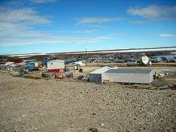
 Part of the town, August 2002
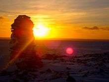
 After the sun has gone below the horizon
 The Igloolik Return of the Sun festival
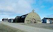 The old stone church, August 2002, prior to being torn down in 2006
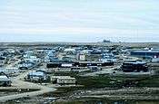
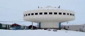 The Igloolik Research Centre
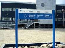 Tummivut Iglu - The Nunavut government building in Igloolik
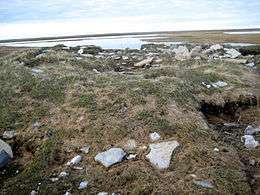 Remnants of older Inuit sod houses in Igloolik Point
See also
References
- ↑ Nunavummiut vie for council positions in upcoming hamlet elections
- ↑ Results for the constituency of Aggu Archived 2013-11-13 at the Wayback Machine. at Elections Nunavut
- ↑ Results for the constituency of Amittuq Archived 2013-11-13 at the Wayback Machine. at Elections Nunavut
- 1 2 3 "Census Profile, 2016 Census". Statistics Canada. Retrieved 2017-03-03.
- ↑ Elevation at airport. Canada Flight Supplement. Effective 0901Z 19 July 2018 to 0901Z 13 September 2018.
- ↑ Igloolik, Nunavut
- ↑ Igloolik at the Qikiqtani Inuit Association Archived 2010-07-06 at the Wayback Machine.
- ↑ "Igloolik, NU". Alias:Arctic Logistics Information and Support. Archived from the original on 2007-08-06. Retrieved 2007-10-17.
- ↑ "Clothing, footwear and territory of the Caribou Inuit". aaanativearts.com. Retrieved 2007-12-26.
- ↑ "Iglulik Inuit". everyculture.com. Retrieved 2007-10-17.
- ↑ Hottest ticket in Malian capital involves the Inuit
- ↑ Artcirq
- ↑ "People Making a Difference". csmonitor.com. Retrieved 2009-12-27.
- ↑ "Igloolik A" (CSV (4222 KB)). Canadian Climate Normals 1981–2010. Environment Canada. Climate ID: 2402543. Retrieved 2013-11-27.
- ↑ "Baffin Island residents resist proposed iron mine plans". CBC News. 2008-04-08. Retrieved 2009-12-12.
- 1 2
Jimmy Thomson (2016-11-02). "Mysterious 'ping' sound from sea floor baffles Igloolik". CBC News. Retrieved 2016-11-03.
Sometimes called a beep, a ping, or a hum, the sound is blamed for scaring away animals.
- ↑ No unusual sounds near Nunavut’s Fury and Hecla Strait, RCAF reports
Further reading
- Allen, Kristiann. Negotiating Health The Meanings and Implications of Building a Healthy Community in Igloolik, Nunavut. Ottawa: National Library of Canada = Bibliothèque nationale du Canada, 2002. ISBN 0-612-64124-4
- Aporta, Claudio. Old Routes, New Trails Contemporary Inuit Travel and Orienting in Igloolik, Nunavut. Ottawa: National Library of Canada = Bibliothèque nationale du Canada, 2004. ISBN 0-612-87930-5
- Dredge, L. A. The Geology of the Igloolik Island Area, and Sea Level Changes. Yellowknife, N.W.T.: Science Institute of the Northwest Territories, 1992.
- Ford, James D., Barry Smit, Johanna Wandel, and John MacDonald. 2006. "Vulnerability to Climate Change in Igloolik, Nunavut: What We Can Learn from the Past and Present". Polar Record (journal). 42, no. 2: 127-138.
- Leontowich, Kent. A Study of the Benthic Faunal Distribution in the Subtidal Zone of Turton Bay, Igloolik Island, Nunavut. Ottawa: National Library of Canada = Bibliothèque nationale du Canada, 2005. ISBN 0-612-92856-X
- Niwranski, K., P. G. Kevan, and A. Fjellberg. 2002. "Effects of Vehicle Disturbance and Soil Compaction on Arctic Collembolan Abundance and Diversity on Igloolik Island, Nunavut, Canada". European Journal of Soil Biology. 38, no. 2: 193-196.
- Wachowich, Nancy. Making a Living, Making a Life Subsistence and the Re-Enactment of Iglulingmiut Cultural Practices. Vancouver: University of British Columbia, 2001. ISBN 0-612-61191-4
External links
| Wikimedia Commons has media related to Igloolik. |