Ōi, Kanagawa
| Ōi 大井町 | |||
|---|---|---|---|
| Town | |||
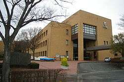 Ōi Town Hall | |||
| |||
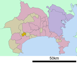 Location of Ōi in Kanagawa Prefecture | |||
 Ōi | |||
| Coordinates: 35°20′N 139°09′E / 35.333°N 139.150°ECoordinates: 35°20′N 139°09′E / 35.333°N 139.150°E | |||
| Country | Japan | ||
| Region | Kantō | ||
| Prefecture | Kanagawa Prefecture | ||
| District | Ashigarakami | ||
| Area | |||
| • Total | 14.41 km2 (5.56 sq mi) | ||
| Population (June 1, 2012) | |||
| • Total | 17,549 | ||
| • Density | 1,220/km2 (3,200/sq mi) | ||
| Time zone | UTC+9 (Japan Standard Time) | ||
| Symbols | |||
| • Tree | Osmanthus fragrans | ||
| • Flower | Narcissus | ||
| • Bird | Japanese white-eye | ||
| Phone number | 0465-83-1311 | ||
| Address | 1995 Kaneko, Ōi-machi, Ashigarakami-gun, Kanagawa-ken 258-8501 | ||
| Website | https://www.town.oi.kanagawa.jp/ | ||


Ōi (大井町 Ōi-machi) is a town located in Kanagawa Prefecture, Japan. As of June 2012, the town had an estimated population of 17,549, and a population density of 1,220 persons per km2. The total area is 14.41 km2.
Geography
Ōi is located in hilly west-central Kanagawa Prefecture, bordering on the Tanzawa Mountains.
Surrounding municipalities
History
During the Edo period, the area around present-day Ōi was part of Odawara Domain in Sagami Province. After the Meiji Restoration, it became part of Ashigarakami District in Kanagawa Prefecture. On April 1, 1889, the district of Ashigarakami was administratively divided into villages, including Kaminaka, Soga, Yamada and Kaneda. On November 3, 1943, the villages of Yamada and Kaminaka merged to form the village of Aiwa. Aiwa later lost a portion of its territory to neighboring Nishihadano on June 20, 1956. The remaining portion merged with Kaneda and portions of Soga to form Ōi on April 1, 1956.
Economy
The economy of the Ōi is primarily agricultural.
Transportation
Rail
Highway
- Tōmei Expressway (Ōi-Matsuda Interchange)
- Japan National Route 255
External links
| Wikimedia Commons has media related to Oi, Kanagawa. |
- Official Website (in Japanese)
| Wards of Yokohama | ||
|---|---|---|
| Wards of Kawasaki | ||
| Wards of Sagamihara | ||
| Core city | ||
| Special cities | ||
| Cities | ||
| Districts | ||