Kamothe
| Kamothe Mansarovar / Khandeshwar | |
|---|---|
| Town | |
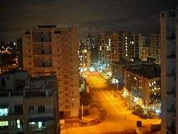 Kamothe-Sector36 at night | |
 Kamothe | |
| Coordinates: 19°01′00″N 73°05′47″E / 19.016804°N 73.096461°ECoordinates: 19°01′00″N 73°05′47″E / 19.016804°N 73.096461°E | |
| Country | India |
| State | Maharashtra |
| District | Raigad |
| Languages=Hindi,Marathi | |
| Time zone | UTC+5:30 (IST) |
| PIN | 410206/410209 |
| Telephone code | 022 -------- |
| Vehicle registration | MH 43,MH 46 and MH 06 |
Kamothe is a node of Navi Mumbai developed and maintained by CIDCO. Kamothe is located on the Sion Panvel Highway. It is the third node after Panvel and Kalamboli towards Mumbai.
Location
The site of Kamothe adjoins the Central Business District of Belapur (CBD Belapur) of Navi Mumbai and is surrounded by Kharghar in its north, Taloja in north-east, Kalamboli in its east and Panvel in its south. The western region of Kamothe is a wet land area with enormous mangroves.
Characteristics
Kamothe is divided into 48 Sectors. Though these sectors are not placed evenly, they are systematic and are in a planned manner. Each sector has its own information map.
Transportation
Kamothe is located on the outskirts of Mumbai. It lies in what is commonly regarded as the Konkan part of Maharashtra and falls in Raigad district.
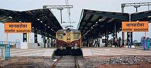
Kamothe has two railway stations Mansarovar and Khandeshwar that lie on the harbour line, a part of Mumbai suburban railways.
Auto rickshaws provide the primary means of personal local transportation. They ply from Mansarovar railway station to the Mumbai-Pune Expressway. Also from Khandeshwar station to Sector 22/24 kamothe, Sector 18 kamothe and Khanda colony. These auto rickshaws serve in a share-rickshaw facility.
BEST, NMMT and MSRTC/ST buses serve as another means of transportation over a long distance to various nodes through Navi Mumbai.
References
| Wikimedia Commons has media related to Navi Mumbai. |