Kalungu District
| Kalungu District | |
|---|---|
| District | |
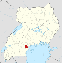 District location in Uganda | |
| Coordinates: 00°06′S 31°49′E / 0.100°S 31.817°ECoordinates: 00°06′S 31°49′E / 0.100°S 31.817°E | |
| Country |
|
| Region | Central Uganda |
| Capital | Kalungu |
| Area | |
| • Land | 811.6 km2 (313.4 sq mi) |
| Population (2012 Estimate) | |
| • Total | 177,200 |
| • Density | 218.3/km2 (565/sq mi) |
| Time zone | UTC+3 (EAT) |
| Website |
www |
Kalungu District is a district in Central Uganda. It is named after the main town of the district, Kalungu, where the district headquarters are located.
Location
Kalungu District is bordered by Gomba District to the north, Butambala District to the north-east, Mpigi District to the east, Masaka District to the south, and Bukomansimbi District to the west. The district headquarters, Kalungu, are 21 kilometres (13 mi), by road, north-east of the city of Masaka, the largest metropolitan area in the sub-region.[1]
Overview
Kalungu District was created by Act of Parliament, carved from Masaka District.[2] The district began functioning on 1 July 2010.
Population
In 1991, the national population census estimated the district population at 152,030. The 2002 national census put the population at approximately 160,700. As of July 2012, the population was estimated at 177,200.[3]
References
- ↑ "Road Distance Between Masaka And Kalungu With Map". Globefeed.com. Retrieved 14 May 2014.
- ↑ Mambule, Ali (12 January 2010). "Uganda: Two Districts to be Carved from Masaka". All Africa. Retrieved 5 March 2016.
- ↑ "Estimated Population of Kalungu District In 1991, 2002 & 2012". Citypopulation.de. Retrieved 14 May 2014.