Kabale District
| Kabale District | |
|---|---|
| District | |
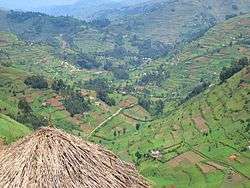 Kabale's landscape | |
 District location in Uganda | |
| Coordinates: 01°15′S 30°0′E / 1.250°S 30.000°ECoordinates: 01°15′S 30°0′E / 1.250°S 30.000°E | |
| Country |
|
| Region | Western Region |
| Sub-region | Kigezi sub-region |
| Capital | Kabale |
| Area | |
| • Land | 1,679.1 km2 (648.3 sq mi) |
| Population (2012 Estimate) | |
| • Total | 498,300 |
| • Density | 296.8/km2 (769/sq mi) |
| Time zone | UTC+3 (EAT) |
| Website |
www |
Kabale District is a district in the Western Region of Uganda. Kabale hosts the district headquarters. It was originally part of Kigezi District, before the districts of Rukungiri, Kanungu, and Kisoro were excised to form separate districts.
Kabale is sometimes nicknamed "Kastone" as in the local language Rukiga, a "kabale" is a small stone.
Location
The Kabale District is bordered by Rukungiri District to the north, Rukiga District to the north-east, Rwanda to the east and south, Rubanda District to the west, and Kanungu District to the north-west. Kabale is approximately 420 kilometres (260 mi), by road, south-west of Kampala, the capital of Uganda.[1]
Population
The 1991 national population census estimated the population of the district at 417,200. The national census in 2012 estimated the population at 458,300. In 2012, the population was estimated at 498,300.[2]
Notable people
- David Bahati, Ugandan MP infamous in the international community for authoring the 2009 Uganda Anti-Homosexuality Bill
- Amama Mbabazi, former Prime Minister
- Ruhakana Rugunda, Current Prime Minister of Uganda
- Ezra Suruma, economist
- Collins Mugisha, Academician, Technologist
- Emmanuel Tumusiime-Mutebile, governor of Bank of Uganda
- Shem Bageine, Ugandan politician.
- George Kanyeihamba, Retired Judge
- Avitus Tibarimbasa (RIP), Politician, Academician
- Jean Nkeramugaba,(RIP), Politician, Author, Educator
- Francis Runumi, Doctor, Politician
- Salvias Ahurwendeire, Academician, Health IT Specialist
- Paul Ngorogoza OBE, KSG, Author
- Festo Karwemera, Author
See also
References
- ↑ 556&tolng=30.0038889 "Map Showing Kampala And Kabale With Distance Marker" Check
|url=value (help). Globefeed.com. Retrieved 19 May 2014. - ↑ "Estimated Population of Kabale District In 1991, 2002 & 2012". Citypopulation.de. Retrieved 19 April 2014.