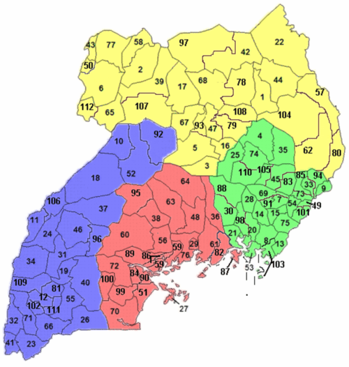
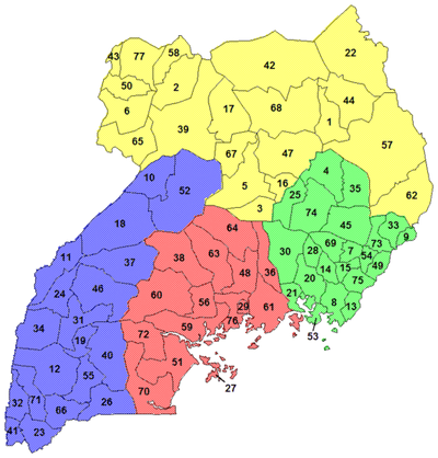
Central Region
(red)
| Map | District | pop. |
|---|
| 82 | Buikwe | 422,771 |
| 84 | Bukomansimbi | 151,413 |
| 86 | Butambala | 100,840 |
| 87 | Buvuma | 89,890 |
| 89 | Gomba | 159,922 |
| 27 | Kalangala | 54,293 |
| 90 | Kalungu | 183,232 |
| 29 | Kampala | 1,507,080 |
| 36 | Kayunga | 368,062 |
| 38 | Kiboga | 148,218 |
| 95 | Kyankwanzi | 214,693 |
| 48 | Luweero | 456,958 |
| 99 | Lwengo | 274,953 |
| 100 | Lyantonde | 93,753 |
| 51 | Masaka | 297,004 |
| 56 | Mityana | 328,964 |
| 59 | Mpigi | 250,548 |
| 60 | Mubende | 684,337 |
| 61 | Mukono | 596,804 |
| 63 | Nakaseke | 197,369 |
| 64 | Nakasongola | 181,799 |
| 70 | Rakai | 516,309 |
| 72 | Ssembabule | 252,597 |
| 76 | Wakiso | 1,997,418 |
|
|
Eastern Region
(green)
| Map | District | pop. |
|---|
| 4 | Amuria | 270,928 |
| 7 | Budaka | 207,597 |
| 49 | Bududa | 210,173 |
| 8 | Bugiri | 382,913 |
| 83 | Bukedea | 203,600 |
| 9 | Bukwa | 89,356 |
| 85 | Bulambuli | 174,508 |
| 13 | Busia | 323,662 |
| 15 | Butaleja | 224,153 |
| 88 | Buyende | 323,067 |
| 20 | Iganga | 504,197 |
| 21 | Jinja | 471,242 |
| 25 | Kaberamaido | 215,026 |
| 28 | Kaliro | 236,199 |
| 30 | Kamuli | 486,319 |
| 33 | Kapchorwa | 105,186 |
| 35 | Katakwi | 166,231 |
| 91 | Kibuku | 202,033 |
| 45 | Kumi | 239,268 |
| 94 | Kween | 93,667 |
| 98 | Luuka | 238,020 |
| 101 | Manafwa | 353,825 |
| 53 | Mayuge | 473,239 |
| 54 | Mbale | 488,960 |
| 103 | Namayingo | 215,442 |
| 14 | Namutumba | 252,562 |
| 105 | Ngora | 141,919 |
| 69 | Pallisa | 386,890 |
| 110 | Serere | 285,903 |
| 73 | Sironko | 242,422 |
| 74 | Soroti | 296,833 |
| 75 | Tororo | 517,082 |
|
|
Northern Region
(yellow)
| Map | District | pop. |
|---|
| 1 | Abim | 107,966 |
| 2 | Adjumani | 225,251 |
| 78 | Agago | 227,792 |
| 79 | Alebtong | 227,541 |
| 3 | Amolatar | 147,166 |
| 80 | Amudat | 105,767 |
| 39 | Amuru | 186,696 |
| 5 | Apac | 368,626 |
| 6 | Arua | 782,077 |
| 16 | Dokolo | 183,093 |
| 17 | Gulu | 436,345 |
| 22 | Kaabong | 167,879 |
| 42 | Kitgum | 204,048 |
| 43 | Koboko | 206,495 |
| 93 | Kole | 239,327 |
| 44 | Kotido | 181,050 |
| 97 | Lamwo | 134,379 |
| 47 | Lira | 408,043 |
| 50 | Maracha | 186,134 |
| 57 | Moroto | 103,432 |
| 58 | Moyo | 139,012 |
| 62 | Nakapiripirit | 156,690 |
| 104 | Napak | 142,224 |
| 65 | Nebbi | 396,794 |
| 107 | Nwoya | 133,506 |
| 108 | Otuke | 104,254 |
| 67 | Oyam | 383,644 |
| 68 | Pader | 178,004 |
| 77 | Yumbe | 484,822 |
| 112 | Zombo | 240,082 |
|
|
Western Region
(blue)
| Map | District | pop. |
|---|
| 81 | Buhweju | 120,720 |
| 10 | Buliisa | 113,161 |
| 11 | Bundibugyo | 224,387 |
| 12 | Bushenyi | 234,440 |
| 18 | Hoima | 572,986 |
| 19 | Ibanda | 249,625 |
| 26 | Isingiro | 486,360 |
| 23 | Kabale | 528,231 |
| 24 | Kabarole | 469,236 |
| 31 | Kamwenge | 414,454 |
| 32 | Kanungu | 252,144 |
| 34 | Kasese | 694,992 |
| 37 | Kibaale | 785,088 |
| 40 | Kiruhura | 328,077 |
| 92 | Kiryandongo | 266,197 |
| 41 | Kisoro | 281,705 |
| 96 | Kyegegwa | 281,637 |
| 46 | Kyenjojo | 422,204 |
| 52 | Masindi | 291,113 |
| 55 | Mbarara | 472,629 |
| 102 | Mitooma | 183,444 |
| 106 | Ntoroko | 67,005 |
| 66 | Ntungamo | 483,841 |
| 109 | Rubirizi | 129,149 |
| 71 | Rukungiri | 314,694 |
| 111 | Sheema | 207,343 |
|