Busia District
| Busia District | |
|---|---|
| District | |
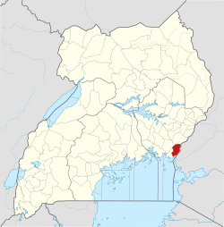 District location in Uganda | |
| Coordinates: 00°23′N 34°00′E / 0.383°N 34.000°ECoordinates: 00°23′N 34°00′E / 0.383°N 34.000°E | |
| Country | Uganda |
| Region | Eastern Region of Uganda |
| Capital | Busia |
| Area | |
| • Land | 730.9 km2 (282.2 sq mi) |
| Population (2012 Estimate) | |
| • Total | 297,600 |
| • Density | 407.2/km2 (1,055/sq mi) |
| Time zone | UTC+3 (EAT) |
| Website |
www |
Busia District is a district in the Eastern region of Uganda.
Location
Busia District borders Tororo District to the north, Busia County, Kenya to the east, Tanzania to the south, Namayingo District to the south-west, and Bugiri District to the west. Busia, Uganda, the site of the district headquarters, is approximately 35 km (22 mi) by road south of Tororo, the nearest large town.[1]
Population
During the 1991 national population census, the population in the district was estimated at 163,600. In 2002, the national census estimated the population at 225,000. In 2012, the mid-year population of was estimated at 297,600.[2]
Notable people
Notable people from Busia District include:
- Aggrey Awori - Former Uganda Minister of Information Technology (2009-2011)
- Barbara Nekesa Oundo, state minister for Karamoja affairs and the Busia District women's representative in the parliament (since 2011)
- Benjamin Joseph Odoki, former chief justice of Uganda
- James Munange Ogoola, principal judge of Uganda
- Denis Onyango, Ugandan international association football goalkeeper
- Gabriel Opio, former minister of gender, culture and labour (2009-2011)
- Fred Wabwire-Mangen, professor of epidemiology, Makerere University School of Public Health
- Kevinah Taaka Wanaha Wandera - Member of Parliament, Busia Municipality(2011-2016)
Points of interest
The following points of interest are in the district:
- Majanji landing site on Lake Victoria for fish, which is one of the main foods in the district.
- Busitema Forest is roughly 25 km2 (10 sq mi); it is bisected by the main highway between Uganda and Kenya in Busia.
See also
References
- ↑ "Road Distance Between Tororo And Busia With Map". Globefeed.com. Retrieved 10 May 2014.
- ↑ "Estimated Population of Busia District In 1991, 2002 & 2012". Citypopulaton.de. Retrieved 9 May 2014.
This article is issued from
Wikipedia.
The text is licensed under Creative Commons - Attribution - Sharealike.
Additional terms may apply for the media files.