Köse
| Köse | |
|---|---|
| District | |
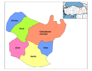 Location of Köse within Turkey. | |
 Köse Location of Köse | |
| Coordinates: 40°13′N 39°39′E / 40.217°N 39.650°E | |
| Country |
|
| Region | Black Sea |
| Province | Gümüşhane |
| Government | |
| • Mayor | Şerif Aygün (AKP) |
| Area[1] | |
| • District | 470.91 km2 (181.82 sq mi) |
| Elevation | 1,553 m (5,095 ft) |
| Population (2012)[2] | |
| • Urban | 3,481 |
| • District | 7,581 |
| • District density | 16/km2 (42/sq mi) |
| Time zone | UTC+2 (EET) |
| • Summer (DST) | UTC+3 (EEST) |
| Postal code | 29xxx |
| Area code(s) | 406 |
| Licence plate | 29 |
| Climate | Dsb |
| Website | www.kose.bel.tr |
Köse is a town and district of Gümüşhane Province in the Black Sea region of Turkey. According to the 2000 census, population of the district is 7,265 of which 3,162 live in the town of Köse.[3][4] The district covers an area of 471 km2 (182 sq mi),[5] and the town lies at an elevation of 1,553 m (5,095 ft).
Köse district has 14 villages, namely Kayadibi, Kabaktepe, Gökçeköy, Akbaba, Özbeyli, Yuvacık, Örensar, Subaşı, Altıntaş, Bizgili, Övünce, and Salyazı which is a small town.
Notes
- ↑ "Area of regions (including lakes), km²". Regional Statistics Database. Turkish Statistical Institute. 2002. Retrieved 2013-03-05.
- ↑ "Population of province/district centers and towns/villages by districts - 2012". Address Based Population Registration System (ABPRS) Database. Turkish Statistical Institute. Retrieved 2013-02-27.
- ↑ Statistical Institute
- ↑ GeoHive. "Statistical information on Turkey's administrative units". Archived from the original on 2009-10-15. Retrieved 2008-12-02.
- ↑ Statoids. "Statistical information on districts of Turkey". Retrieved 2008-12-02.
References
- Falling Rain Genomics, Inc. "Geographical information on Köse, Turkey". Retrieved 2008-12-02.
External links
![]()
Coordinates: 40°12′36″N 39°39′04″E / 40.21000°N 39.65111°E
This article is issued from
Wikipedia.
The text is licensed under Creative Commons - Attribution - Sharealike.
Additional terms may apply for the media files.