Gümüşhane
| Gümüşhane | |
|---|---|
| Municipality | |
 Gümüşhane | |
 Gümüşhane | |
| Coordinates: 40°27′35″N 39°28′40″E / 40.45972°N 39.47778°ECoordinates: 40°27′35″N 39°28′40″E / 40.45972°N 39.47778°E | |
| Country | Turkey |
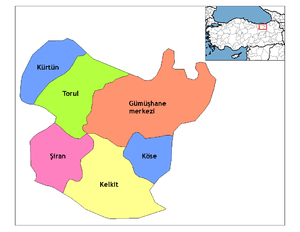
| Province | Gümüşhane |
| Government | |
| • Mayor | Ercan Çimen (AKP) |
| Area[1] | |
| • District | 1,788.83 km2 (690.67 sq mi) |
| Elevation | 1,227 m (4,026 ft) |
| Population (2012)[2] | |
| • Urban | 32,444 |
| • District | 44,888 |
| • District density | 25/km2 (65/sq mi) |
| Website | www.gumushane.bel.tr |
Gümüşhane or Gyumushkhana (Turkish: [ɟyˈmyʃaːˌne] (![]()
History
It is suggested that the ancient Thia (Θεία in Greek, a settlement of Roman, Late Roman and Byzantine periods) was located 4 miles west of modern Gümüşhane, in modern Beşkilise. In Byzantine period, there was a town named Tzanicha or Tzantzakon (Τζάνιχα, Τζάντζακον in Byzantine Greek), possibly located 2 miles to the west of Gümüşhane.[5][6]
Around 840 AD, the area was included in the new Roman (Byzantine) province of Chaldia (Χαλδία).[7] It was later ruled by the Byzantine Empire of Trebizond.
During Ottoman years, the sanjak of Gümüşhane fell under the administration successively Rum Province, Erzurum Province and Trabzon Province, and was divided into four kazas: Gümüşhane, Torul (capital city Ardassa), Şiran (Cheriana), and Kelkit (Keltik).
The sanjak in which Gümüşhane was situated at some stage comprised 37 mines of argentiferous lead and six copper mines. There is no evidence that these mines were in use during Byzantine times.
As for the name of the city during the Ottoman period, Greek-speaking population was also using the name Gümüşhane (Γκιμισχανά and Κιουμουσχανά) but, in the first decades of 19th century, the hellenized form Argyròpolis (Αργυρόπολις, from argyros "silver" and polis "city") was established.[8]
The Arghyropolis belonged to the Diocese of Chaldie (145 communities, 77,845 inhabitants). During the 1914-1918 Persecution of Greeks, the Turkish authorities boycott the Christians. The boycott deprived the Christians of all they possessed and reduced them to absolute poverty. The organizer of the boycott was the Djemal Azmi, Vali of Trebizonde, under whose orders were the Governor of Arghyropolis and others. In the sterile region of Argliyropolis the distress was great, because the inhabitants were entirely dependent for their existence on their local trade, and that from Russia. General mobilization was also among the causes conducive to the ruin of the Greek communities, for the male inhabitants who supported their families were taken away from their homes. The Turkish officers treated the Greeks shameful and brutal, making many Greeks to desert. This was the situation before the Russian advance.[9]
The Russian advance gave rise to a fresh outburst of fanaticism against the Greek element, the Turks from Turkish villages plundered the Christian villages of the region. During the Turkish retreat, the Turks pillaged many Greek villages of the region, the inhabitants took to the mountains and their property was plundered. Later on the retreat of the Russians, the Turks returned and the few inhabitants that remained in these villages, deprived of all resources and left to die of hunger. [9]
Geography
Gümüşhane is surrounded by high mountains, Zigana-Trabzon Mountains to the north, Çimen Mountains to the south, Giresun Mountains to the west and Pulur, Soğanlı Mountains to the east. Trekking is popular sport is at these mountains. Mount Zigana has a ski center on it and it is a well known tourist destination for winter sports. Abdal Musa Peak (3331 m.) is the highest peak within it. The main trees in the forests are Scotch pine and fir, and there are many animals and birds in the area. There are many lakes such as Karanlık Göl, Beş Göller, Artebel Gölü, Kara Göller which are at the peak of Gavurdağı Mountain, and are preserved as natural parks. All these mountains compose 56% of the area of Gümüşhane province.
Climate
Gümüşhane has a humid continental climate (Köppen climate classification: Dsb on the border Dfb) with cold and snowy winters and warm summers. In the height of summer; July and August, temperatures at midday usually surpass 28 °C, summer nights tend to become very cool due to the high elevation of Gümüşhane, and in winter temperatures usually plummet to -10 °C and even go as low as -20 °C occasionally.
| Climate data for Gümüşhane (1960-2012) | |||||||||||||
|---|---|---|---|---|---|---|---|---|---|---|---|---|---|
| Month | Jan | Feb | Mar | Apr | May | Jun | Jul | Aug | Sep | Oct | Nov | Dec | Year |
| Record high °C (°F) | 14.8 (58.6) |
18.0 (64.4) |
24.0 (75.2) |
29.0 (84.2) |
32.5 (90.5) |
36.2 (97.2) |
41.0 (105.8) |
40.0 (104) |
37.0 (98.6) |
32.0 (89.6) |
22.1 (71.8) |
19.2 (66.6) |
41 (105.8) |
| Average high °C (°F) | 2.58 (36.64) |
4.8 (40.6) |
9.6 (49.3) |
16.1 (61) |
21.1 (70) |
24.8 (76.6) |
28.0 (82.4) |
28.5 (83.3) |
25.2 (77.4) |
18.7 (65.7) |
10.5 (50.9) |
4.9 (40.8) |
16.23 (61.22) |
| Daily mean °C (°F) | −1.8 (28.8) |
−0.7 (30.7) |
3.6 (38.5) |
9.4 (48.9) |
13.7 (56.7) |
17.2 (63) |
20.2 (68.4) |
20.1 (68.2) |
16.6 (61.9) |
11.4 (52.5) |
5.0 (41) |
0.5 (32.9) |
9.6 (49.3) |
| Average low °C (°F) | −5.8 (21.6) |
−5.3 (22.5) |
−1.4 (29.5) |
3.7 (38.7) |
7.5 (45.5) |
10.6 (51.1) |
13.7 (56.7) |
13.6 (56.5) |
9.9 (49.8) |
5.8 (42.4) |
0.7 (33.3) |
−3.2 (26.2) |
4.1 (39.5) |
| Record low °C (°F) | −23.6 (−10.5) |
−25.7 (−14.3) |
−22.6 (−8.7) |
−11.0 (12.2) |
−2.8 (27) |
1.8 (35.2) |
4.5 (40.1) |
4.9 (40.8) |
−1.0 (30.2) |
−4.8 (23.4) |
−15.0 (5) |
−21.0 (−5.8) |
−25.7 (−14.3) |
| Average precipitation mm (inches) | 35.0 (1.378) |
31.9 (1.256) |
41.3 (1.626) |
60.9 (2.398) |
66.7 (2.626) |
44.5 (1.752) |
12.6 (0.496) |
12.3 (0.484) |
20.0 (0.787) |
43.1 (1.697) |
42.3 (1.665) |
40.8 (1.606) |
451.4 (17.771) |
| Average precipitation days | 11.2 | 10.9 | 12.5 | 14.1 | 15.5 | 10.3 | 4.3 | 3.6 | 5.2 | 9.4 | 10.3 | 11.6 | 118.9 |
| Mean monthly sunshine hours | 43.4 | 103.6 | 158.1 | 183 | 235.6 | 276 | 313.1 | 306.9 | 243 | 173.6 | 66 | 24.8 | 2,127.1 |
| Source: Devlet Meteoroloji İşleri Genel Müdürlüğü [10] | |||||||||||||
Historic Sites : Architecture and Archaeology
Gümüşhane has a rich historical background so there are many historical places, mosques, churches, castles. Ancient city of Satala in the modern village of Sadak was the most important military camp of the ancient Roman Empire in the east. This place was ruled by the Hittites, Assyrians, Urartu, Persians, Pontic Greeks, Romans, and Byzantines. Today, rests of the Sadak village is protected by the Ministry of Culture and Tourism. In addition, Süleymaniye Mosque is in the previous Gümüşhane settlement and it was commissioned by the Ottoman sultan Süleyman the Magnificent. Küçük Mosque and Çit Village Mosque are some of other popular mosques in the city. Besides, there are numerous churches within Gümüşhane. Santa Çakallı, Santa Terzili, Kalur Rock, Samamoni, and Theodor Churches are some examples of historical churches in Gümüşhane.[11][12] During the medieval period one of the most important guardians of the road connecting Trabzon to Erzincan was the Byzantine fortress located about 2 kilometers northwest of modern Gümüşhane. An archaeological and historical assessment of this site as well as a scaled plan were published in 1985.[13] The impressive circuit walls and defenses are clearly evident at the accessible west approach to the lofty outcrop. In addition to several rooms and cisterns, the castle has two chapels; the easternmost was once covered by a dome.
Natural Beauty : Caves and Plateaux
There are numerous large and small caves which owe their formation to the geology - particularly the limestones - of Gümüşhane, including Alicli Agil Cave, Arili Cave, Altınbaşı Cave, Asarönü Ören Cave, Kartalkaya Cave, Ayiini Cave, K.Ardiçli Cave, Karçukuru Cave, Ardiçli Cave, Tepekli Cave, Uçbacalı Cave, Buz Cave and Ikisu Cave.[13]
A distinctive local wildflower, bearing purple blossoms in Spring and frequently to be found growing in rock crevices around the mouths of Gümüşhane's many caves, is a member of the nightshade genus Physochlaina : Physochlaina orientalis - a plant rich in medicinally valuable tropane alkaloids of the type found also in belladonna.[14]
The cave in Gümüşhane most visited by tourists is the 150 meter-long Karaca Cave, popular because of its spectacular speleothems (= dripstone formations), including stalagmites, stalactites, columns and travertine pools. It is a fossil cave located between Torul and Gümüşhane, in which the lime-rich water percolating through fissures in the roof has slowly built up calcite structures of remarkable beauty and complexity. Other geological features of Gümüşhane noted for their scenic beauty include the numerous plateaux commanding views of the forested areas which surround them. These include the Zigana, Taşköprü, Artabel, Şiran and Kalis plateaux, which form fitting sites for the Summer festivals which are held there annually.
Cuisine
Many native tourists participate in these festivals - not only for entertainment's sake, but also to shop for regional delicacies. Pestil and köme are renowned desserts of Gümüşhane, made from mulberries, honey, hazel nuts, walnuts and milk. In addition to köme and pestil, rosehips, apples, and walnuts are notable local foods put to use in the many different desserts which are numbered among the regional specialities of Gümüşhane. Nor is the town's rich food culture restricted to sweetmeats : mantı, lemis, erişte, borani, kuymak, evelek, dolması and siron feature among the savoury dishes local to Gümüşhane.[15]
Ethnic groups
Pontic Greek influence
The first residents of Gümüşhane settled in the region just after the fall of Trebizond (1461) and the town soon became a home for miners. Sultan Murad ΙΙΙ (1574–1595) appears to have granted extra privileges to the chief miners and the town prospered and soon became a centre of Hellenism. At the time, it had 60,000 residents. Its trade was increasing and the whole province of Chaldia was on the rise. Another example of its development was that they minted coins with the name Kioumous-hane on them. Another example was the settlement of chief mining families there such as the Sarasites, the Karatsades, the Stavracoglous, the Kalimachidises, the Grigorantons and others. There were also more jewellery shops opening, as well as more hagiography and other arts in the region.
The rise in wealth and abundance soon brought positive changes to the communities. From the beginning of the 18th century new schools were opening, and from 1723 the Frontistirion (Greek Tuition Centre) of Argyroupolis was in full operation. The tuition centre became an educational institution and spiritual centre of the region. In 1650 the diocese was elevated to archdiocese status, and hundreds of churches and temples were built. New mines rich in minerals were discovered in Ak-dag Maden and Argoni, which resulted in a large exodus of miners from Argyroupolis to the new mines. The further dramatic fall in population followed the Russo-Turkish War of 1829–30, when many Pontic Greeks of the area collaborated with or welcomed the Russian army that occupied the area. So as to escape likely Turkish reprisals, the majority of the Pontic Greek population followed the Russian army as it withdrew back into Georgia and Southern Russia, many settling there and joining preexisting communities of Caucasus Greeks that had moved eastwards between the fall of the Empire of Trebizond in 1461 and the 1801 Russian annexation of Georgia, including another community of Pontic Greek miners who had settled in Georgia and Armenia in 1778. Some of the Pontic Greek mining families of Gumushane also settled in Nicomedea, Mesopotamia and other mining regions, from Tiflis to as far as Ak-Dag and the Taurus. During those years tension between the Christian Greek and Muslim population was also growing due to the Greek Revolution and the public reversion to Greek Orthodoxy of many of the Stavriotes, Pontic Greeks who had superficially adopted Turkish Islam in the early Ottoman period but who had remained crypto-Christian in private.[16]
During those confusing and troubling times many people became benefactors of Argyroupolis, such as the Sarasite family and the influential teacher Georgios Kyriakidis. Kyriakidis identified the need to extract large sums of money from the churches of Saint George, Saint Theodore, Τίμιου Σταυρού and Παναγίας for the educational needs of the town. Sale of church property as well as donations and consecrations resulted in the erection of a new school at the Frontistirion of Argyroupolis, a school which was to operate until the Exchange (1923). The Frontistirion comprised a three-grade high school, a seven-grade primary school including scholarship classes, and a six-grade girls' school, as well as a carpet-making technical school.
Another public building was the library, the Educational Society Kyriakidis, as well as the Metropolis of Chaldia. The Argyroupolitans therefore are very much regarded as having some of the best resources in education, due mainly to their economic rise as a result of mining.[17]
After the turmoil and ethnic strife (1914–1923), a few ethnic Pontic Greeks managed to flee to Greece. Those that did settled in the Macedonia region of Northern Greece. A small group which settled in Naousa brought precious items with them from their churches in town, as well as items from the library of the Frontistirion, including rare manuscripts and books. This collection is still in use today and is considered a prized asset of Naousa.
The town was occupied by the Russian army on July 20, 1916, but the Russians withdrew on February 15, 1918, after the fall of the czar. After the exchange (1923) no Orthodox remained in the region.
Economy
Historically, Gümüşhane had mulberry tree plantations for sericulture.[18]
Notable natives
- Hasan Fehmi (Ataç), deputy during the Ottoman Empire and after declaration of republic first Minister of Agriculture and Minister of Finance of Turkey
- Mahmut Oltan Sungurlu, Turkey's former Justice Minister and Minister of Defense
- Coşkun Bayrak, academician and philanthropist
- Derya Ertürk, famous local celebrity
- Turgay Erdener, composer and teacher
- Nurettin Özdemir, Poet, Former Member of Parliament
- Basri Erdoğan, Entrepreneur and Businessmen
- Aydın Doğan, Entrepreneur and Businessmen
References
- ↑ "Area of regions (including lakes), km²". Regional Statistics Database. Turkish Statistical Institute. 2002. Retrieved 2013-03-05.
- ↑ "Population of province/district centers and towns/villages by districts - 2012". Address Based Population Registration System (ABPRS) Database. Turkish Statistical Institute. Retrieved 2013-02-27.
- ↑ Statistical Institute
- ↑ Statoids. "Statistical information on districts of Turkey". Retrieved 2008-12-01.
- ↑ Barrington Atlas of the Greek and Roman World: Map by Map directory, p.1237.
- ↑ Procopius of Caesarea, Περί Κτισμάτων, book C, 7.
- ↑ Kiminas 2009, pp. 105.
- ↑ Terezakis Yorgos, Diocese of Chaldia (Ottoman Period), Encyclopaedia of the Hellenic world, Asia Minor.
- 1 2 Persecution of the Greeks in Turkey, 1914-1918. Constantinople [London, Printed by the Hesperia Press]. 1919.
- ↑ "Archived copy". Archived from the original on 2011-04-30. Retrieved 2011-03-19.
- ↑ Gümüşhane (en) Archived 2012-05-11 at the Wayback Machine.
- ↑ Gümüşhane historical places (tr) Archived 2012-05-04 at the Wayback Machine.
- ↑ http://www.visiontours.com.au/index.php/tourism-and-travel/activities/caves/ Retrieved 25 April 2017.
- ↑ Flora of Turkey and the East Aegean Islands ed. Davis,P.H., pub. University of Edinburgh Press 1978, reprinted 1997, 2001 and 2008. ISBN 0 85224 336 7
- ↑ Traditional food Archived 2012-05-11 at the Wayback Machine.
- ↑ Who were the crypto-Christians?, Crypto-Christians of the Trabzon Region of Pontos Archived 2012-05-11 at the Wayback Machine.
- ↑ Özhan Öztürk, Pontus: Antik Çağ’dan Günümüze Karadeniz’in Etnik ve Siyasi Tarihi Genesis Publishing. Ankara, 2011 pp. 695-701
- ↑ Prothero, W.G. (1920). Armenia and Kurdistan. London: H.M. Stationery Office. p. 64.
Literature
- The Encyclopedia of Pontian Hellenism. Malliaris Pedia.
- The Byzantine Monuments and Topography of the Pontos . Anthony Bryer, David Winfield. Dumbarton Oaks p. 3
- Kiminas, Demetrius (2009). The Ecumenical Patriarchate: A History of Its Metropolitanates with Annotated Hierarch Catalogs. Wildside Press LLC.
- Falling Rain Genomics, Inc. "Geographical information on Gümüşhane, Turkey". Retrieved 2008-12-01.
- Turkish Ministry of Culture and Tourism. "Mosques, Mausoleums and Churches in Gümüşhane". Archived from the original on 2012-12-21. Retrieved 2009-03-05.
External links
![]()
- Governor's official website (in Turkish)
- Municipality's official website (in Turkish)
- Argyroupoolis (Gümüşhane)