Inn (river)
| Inn | |
|---|---|
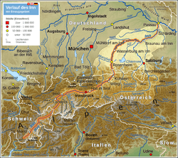 Map highlighting the Inn | |
| Other name(s) | Romansh: En |
| Countries | Switzerland, Austria, Germany |
| Cities | St. Moritz, Scuol, Landeck, Innsbruck, Wörgl, Kufstein, Rosenheim, Wasserburg am Inn, Mühldorf am Inn, Braunau am Inn, Schärding, Passau |
| Physical characteristics | |
| Main source |
Swiss Alps (Lägh dal Lunghin) 2,484 m (8,150 ft) 46°25′00″N 9°40′35″E / 46.41673°N 9.67645°E |
| River mouth |
Danube (Passau) 291 m (955 ft) 48°34′25″N 13°28′38″E / 48.57353°N 13.47713°ECoordinates: 48°34′25″N 13°28′38″E / 48.57353°N 13.47713°E |
| Length | 518.5 km (322.2 mi) [1] |
| Discharge |
|
| Basin features | |
| Progression | Danube→ Black Sea |
| Basin size | 26,053 km2 (10,059 sq mi) [1] |
The Inn (Latin: Aenus;[2] Romansh: En) is a river in Switzerland, Austria and Germany. It is a right tributary of the Danube and is 518 kilometres (322 mi) long. The highest point of its drainage basin is the summit of Piz Bernina, at 4,049 metres (13,284 ft). The Engadine, the valley of the En, is the only Swiss valley whose waters end up in the Black Sea (via the Danube).
Etymology
The name Inn is derived from the old Celtic words en and enios, which means water in English. In a document of 1338, the river is named Wasser (German for water). The first written mention from the years 105 to 109 (Publii Corneli Taciti historiarium liber tertius) reads: "... Sextilius Felix... ad occupandam ripam Aeni fluminis, quod Raetos Noricosque interfluit, missus..." or: "... Sextilius Felix was sent to capture the banks of the Inn, which flows between the Rhaetian people and the Noric people."[3] The river is also mentioned by other authors of the Roman Empire as Ainos (Greek) or Aenus (Latin). In medieval Latin it is mostly written as Enus, by the humanists Oenus. The change in the old Bavarian language from e to i turns Enus to In. Until the 17th century, it is written like this or Yn, but also Ihn or Yhn. The double-n appears only in the 16th century, for example in the Tyrolian Landreim of 1557, and since the 18th century this spelling and pronunciation with a short vowel has been customary.[4]
The mentions in Roman times refer to the lower course, the Tyrolean section is first called Aenus at Venantius Fortunatus in the 6th century. The name Engadin and the Romansh name En indicate that the upper reaches of the river have always been called this way. Even though it was occasionally believed that the Inn originates near the Adige at the Reschen Pass, since the 16th century at the latest the origin has been seen uniformly in the area of the lakes at the Maloja Pass.[4]
There may be a connection between the name Inn and the name of the French river Ain.[5]
Geography
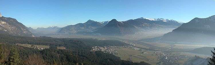
The source is located in the Swiss Alps, west of St. Moritz in the Engadine region, which is named after the river (Romansh Engiadina; Latin vallis Eniatina). Shortly after it leaves its source, the Inn flows through the largest lakes on its course, Lake Sils and Lake Silvaplana. It runs north-eastwards, entering Austria, and from Landeck eastwards through the Austrian state of Tyrol and its capital, Innsbruck (bridge over the Inn), and crosses the border into Bavaria near Kufstein.
On Bavarian territory the river runs northwards and passes Rosenheim, Wasserburg am Inn, and Waldkraiburg; then it turns east, runs through Mühldorf and Neuötting and is enlarged by two major tributaries, the Alz and the Salzach.
From here to the Danube, it forms the border between Germany (Bavaria) and Austria (Upper Austria). Towns on this last section of the river are Marktl am Inn, Simbach on Inn, Braunau am Inn and Schärding.
In Passau the Inn finally enters the Danube (as does the river Ilz there). Although the Inn has a greater average flow than the Danube when they converge in Passau, and its watershed contains the Piz Bernina also the highest point in the Danube watershed, the Inn is considered a tributary of the Danube, which has a greater length, drains a larger surface area, and has a more consistent flow. The Inn is the only river originating in Switzerland that ends in the Black Sea (via the Danube).
Tributaries
- Right tributaries (in downstream order): Flaz, Spöl, Clemgia, Faggenbach, Pitzbach, Ötztaler Ache, Melach, Sill, Ziller, Alpbach, Wildschönauer Ache, Brixentaler Ache, Weißache, Kaiserbach, Rohrdorfer Ache, Sims, Murn, Alz, Salzach, Enknach, Mattig, Ach, Hartbach, Antiesen, Pram
- Left tributaries (in downstream order; note that two different rivers called Rott exist): Beverin, Schergenbach, Sanna, Gurglbach, Brandenberger Ache, Kieferbach, Auerbach, Kirchbach, Mangfall, Rott, Attel, Isen, Rott
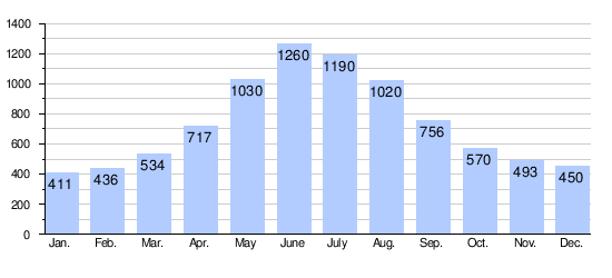
Flow
Average monthly flow (m³/s) of the Inn in Passau
Years 1921/2006[6]
2013 flood
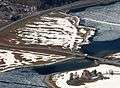
On June 3, 2013, the discharge of the Inn in Passau reached 6,820 m3/s (241,000 cu ft/s)[6] and the water levels reached 12.85 m (42.2 ft), the highest recorded historic flood level since 1501.[7] The historic centre of Passau, where the Danube, Inn and Ilz converge, was flooded severely.
2013 flood image gallery
.jpg) The "Old City" (Die Altstadt) of Passau. In front of the Danube
The "Old City" (Die Altstadt) of Passau. In front of the Danube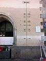 Water level marks on the Town Hall in Passau
Hydroelectric power plants
Currently, there are 23 hydroelectric power plants on the Inn. 17 of them are operated by Verbund AG.[8] The power plants are listed beginning at the headwaters:
| Dam | Nameplate capacity (MW) | Annual generation (Mio. kwh) |
|---|---|---|
| Islas[9] | 4.3 | 17 |
| Ova Spin[10] | 50 | 100 |
| Pradella[11] | 288 | 1,000 |
| Imst[12] | 89 | 550 |
| Kirchbichl[13] | 19.3 | 131 |
| Langkampfen[14] | 31.5 | 169 |
| Oberaudorf-Ebbs | 60 | 268 |
| Nussdorf | 48 | 245.8 |
| Rosenheim | 35 | 179.5 |
| Feldkirchen | 38 | 204 |
| Wasserburg | 29 | 165.7 |
| Teufelsbruck | 25 | 150.4 |
| Gars | 30 | 169.2 |
| Jettenbach | 6 | 30.2 |
| Töging | 85 | 564.6 |
| Neuötting | 26 | 159.4 |
| Perach | 19 | 128.4 |
| Stammham | 23 | 136.4 |
| Braunau-Simbach | 100 | 550 |
| Ering-Frauenstein | 72 | 434 |
| Egglfing-Obernberg | 84 | 485 |
| Schärding-Neuhaus | 96 | 541.8 |
| Passau-Ingling | 86 | 504.7 |
Image gallery
 Bridge over the Inn at Silvaplana, Upper Engadine (CH)
.jpg) Inn between Susch and Lavin, Lower Engadine (CH)
Inn between Susch and Lavin, Lower Engadine (CH)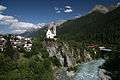 The Inn in Scuol, Lower Engadine (CH)
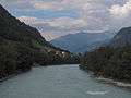 Between Stein and Pfunds in the upper part of the Upper Inn Valley (A)
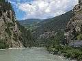 Between Aussengufer and Fließ in the upper part of the Upper Inn Valley (A)
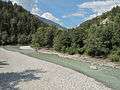 Between Nesselgarten and Prutz in the upper part of the Upper Inn Valley (A)
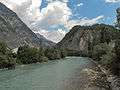 Near Landeck (A)
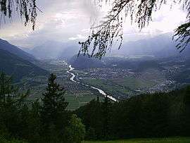
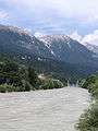 The Inn in Innsbruck (A)
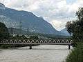 Rotholz (bei Jenbach), Lower Inn Valley, bridge across the Inn (A)
References
- 1 2 Complete table of the Bavarian Waterbody Register by the Bavarian State Office for the Environment (xls, 10.3 MB)
- ↑ Richard J.A. Talbert, ed. (2000). Barrington Atlas of the Greek and Roman World: Map-By-Map Directory. I. Princeton, NJ and Oxford, UK: Princeton University Press. p. 171. ISBN 0691049459.
- ↑ "Wolf-Armin Frhr. v. Reitzenstein: Lexikon bayerischer Ortsnamen. Herkunft und Bedeutung. C.H.Beck, Munich 2006
- 1 2 Otto Stolz: Geschichtskunde der Gewässer Tirols. Schlern-Schriften, Band 32, Innsbruck 1932, S. 6–14 und 83–88 (Digitalisat)
- ↑ Arnaud Vendryes: L'Ain : le nom d'une rivière à travers les sources. In: Société d'Emulation du Jura, Travaux 2015, S. 147–168
- 1 2 "Statistik Passau Ingling / Inn" (in German). www.hnd.bayern.de. Retrieved 2016-04-05.
- ↑ "Central Europe Hit by Rains, Floods and Landslides: AIR Analysis". www.insurancejournal.com. 2013-04-06. Retrieved 2016-04-05.
- ↑ "VERBUND on the Inn". Verbund. Retrieved 2016-01-18.
- ↑ "Elektrizitäts-Produktion" (in German). www.stmoritz-energie.ch. Retrieved 2016-01-18.
- ↑ "Zentrale Ova Spin" (in German). Engadiner Kraftwerke. Retrieved 2016-01-18.
- ↑ "Zentrale Pradella" (in German). Engadiner Kraftwerke. Retrieved 2016-01-18.
- ↑ "Kraftwerk Imst" (in German). Tiwag. Retrieved 2016-01-18.
- ↑ "Kraftwerk Kirchbichl" (in German). Tiwag. Retrieved 2016-01-18.
- ↑ "Kraftwerk Langkampfen" (in German). Tiwag. Retrieved 2016-01-18.
External links
| Wikimedia Commons has media related to Inn River. |
- Inn (district and river) in Romansh, German, French and Italian in the online Historical Dictionary of Switzerland.
| Countries | 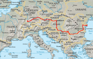 | |
|---|---|---|
| Cities | ||
| Tributaries | ||
| See also | ||