Morava (river)
| Morava | |
| River | |
 The Morava between Austria and Slovakia | |
| Countries | Czech Republic, Slovakia, Austria |
|---|---|
| Regions | Pardubice, Olomouc, Zlín, South Moravian, Trnava, Bratislava, Lower Austria |
| Tributaries | |
| - left | Krupá, Branná, Desná, Oskava, Bečva, Dřevnice, Olšava, Velička, Myjava |
| - right | Mírovka, Moravská Sázava, Haná, Thaya |
| Cities | Olomouc, Kroměříž, Uherské Hradiště, Hodonín, Holíč, Bratislava, Marcheeg |
| Source | |
| - location | Králický Sněžník |
| - elevation | 1,275[1] m (4,183 ft) |
| - coordinates | 50°12′18″N 16°50′57″E / 50.20500°N 16.84917°E |
| Mouth | Danube |
| - location | Devín |
| - coordinates | 48°10′27″N 16°58′32″E / 48.17417°N 16.97556°ECoordinates: 48°10′27″N 16°58′32″E / 48.17417°N 16.97556°E |
| Length | 354[1] km (220 mi) |
| Basin | 27,267[1] km2 (10,528 sq mi) |
| Discharge | |
| - average | 120 m3/s (4,238 cu ft/s) |
| Progression | Danube→ Black Sea |
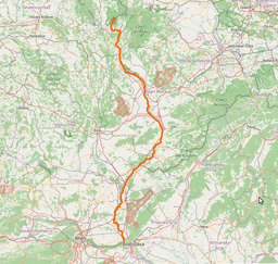 | |
The Morava (German: March, Hungarian: Morva, Polish: Morawa) is a river in Central Europe, a left tributary of the Danube. It is the main river of Moravia, which derives its name from it. The river originates on the Králický Sněžník mountain in the north-eastern corner of Pardubice Region, near the border between the Czech Republic and Poland and has a vaguely southward trajectory. The lower part of the river's course forms the border between the Czech Republic and Slovakia and then between Austria and Slovakia.
Etymology
Though the German name March may refer to Mark, "border, frontier" (cf. English march), the river's name more probably is derived from Proto-Indo-European *mori, "waters" (mare). It was first documented as Maraha in an 892 deed.
History
The shores of the Morava have been inhabited for a very long time. The village of Stillfried, in the Austrian part of the river course, has been the place of a human settlement already 30,000 years ago.[1] Agriculture began to be practiced in the Morava valley approximately 7,000 years ago. Fortified settlements began to appear in the river valley during the New Stone Age.[1]
The lower part of the river, downstream of the confluence with the Thaya at Hohenau an der March, which today marks the Austro-Slovakian border, is one of the oldest national boundaries still extant in continental Europe: it was the eastern boundary of the Carolingian Empire with the Avar Khaganate around 800 and from the 10th century onwards marked the border of the Imperial marcha orientalis, later Duchy of Austria with the Kingdom of Hungary (within the Habsburg Monarchy during 1526–1918 due to the imperial expansion of the Austrian lands). At the times of the Cold War, this section of the river was part of the Iron curtain, being the frontier between Austria and Czechoslovakia.
1997 flooding
In July 1997, the Morava basin (especially its northern and eastern part) was affected by heavy stratiform raining, which lasted several days and caused catastrophic floods also on the Oder River basin in Poland and Germany. In the Czech Republic, 49 people lost their life, more than 250 villages had to be evacuated and the total damage cost 63 billion crowns.
History of the river
 Skeletons of a family (9th century BC) of the Urnfield culture site at Stillfried
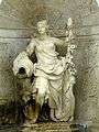 An allegorical representation of Morava at Schloss Hof in Austria
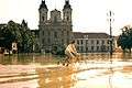 The flood of 1997 in Uherské Hradiště
Course
The river originates in the Králický Sněžník mountains in north-western Moravia, not far from the border with Poland. The lowlands formed by the river are the Upper Moravian Vale or Hornomoravský úval and then the Lower Moravian Vale or Dolnomoravský úval in Moravia, the Moravian Field or Marchfeld in Lower Austria, and the Záhorie Lowland or Záhorská nížina in Slovakia. The latter three are actually continuous parts of one large basin, forming the major part of the Vienna Basin.
In the Czech Republic, there are some larger towns lying upon Morava, particularly Olomouc, Kroměříž, Otrokovice, Uherské Hradiště and Hodonín. Brno, the second largest city of Czech Republic, lies within the river basin.[1] The catchment area of the river has a population of c. 3,5 million people.[1] Downstream from Hodonín, the river flows along sparsely inhabited, forested border area, all the way to its outfall into the Danube, just below the Devín Castle at the outskirts of the Slovak capital Bratislava. After 354 km of its course, Morava feeds the Danube by an average discharge rate of 120 m3/s, gathered from a drainage area of 26 658 km2.
The river's longest tributary by far is the Thaya (in German) or Dyje (in Czech),[1] flowing in at the tripoint of Austria, the Czech Republic and Slovakia. The biggest tributary from the left is Bečva.
The Morava is a lowland river with a basin that consists to 51 percent of plains; mountains make up only seven percent of the basin while 35 percent are considered highland. The average slope of the river is 1.8‰ and at the confluence 4‰.[1] The bedrock of the river basin is mostly crystalline bedrock and flysch.[1]
The Morava river is unusual in that it is a European blackwater river.
Course of the river
.JPG) The source of the Morava on Králický Sněžník
The source of the Morava on Králický Sněžník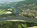 The confluence of the Morava and the Danube
 Morava in Olomouc
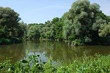 Thaya-Morava confluence - intersection of three borders, Austrian, Czech and Slovak
Ecology
The Morava river forms an important link between the Danube Valley and the plains of northern Europe, for animals as well as, at least historically, for humans. Its weak slope across flat plains furthermore means that the river is prone to meander and flood, creating vast floodplains. Because of these reasons, the floodplains of the Morava river are among the most biologically diverse ecosystems in Europe.[1] Its richness in plant and animal species (some 12,000 species have been identified) ranks it second in diversity only to the Danube Delta. During the 20th century however, large tracts of the river, especially downstream from Litovel, have been regulated with the ensuing effect of loss of inundation areas (floodplains). Since the river basin is densely populated and, especially the Czech part, industrialised, the river also receives a lot of wastewater. Agriculture also contributes to spreading nitrogen and other nutrients into the river. Nevertheless, the central part of the river has retained much of its natural character and in later years conscious efforts have been made to protect the nature and ecosystem of the river basin.[1]
Ecology of the river
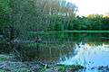 Flooded forest
 Flooded meadow
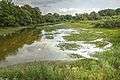 One of many oxbow lakes of the Morava
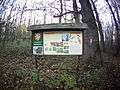 Nature park Strážnické Pomoraví in Czech Republic, one of several protected natural areas along the Morava
See also
References
External links
| Wikimedia Commons has media related to Morava River. |

| Countries |  | |
|---|---|---|
| Cities | ||
| Tributaries | ||
| See also | ||