Lägh dal Lunghin
| Lägh dal Lunghin | |
|---|---|
| Location | Engadin, Grisons |
| Coordinates | 46°25′08″N 9°40′32″E / 46.41889°N 9.67556°ECoordinates: 46°25′08″N 9°40′32″E / 46.41889°N 9.67556°E |
| Basin countries | Switzerland |
| Average depth | 9.2 m (30 ft) |
| Surface elevation | 2,484 m (8,150 ft) |
| Frozen | November - July (ice) |
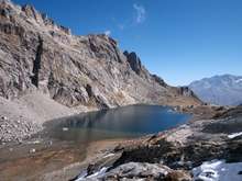
Lägh dal Lunghin (German: Lunghinsee) is a lake at an elevation of 2484 m, below the peak of Piz Lunghin, in the Graubünden, Switzerland. It is considered the source of the Inn River.
Lägh dal Lunghin
This article is issued from
Wikipedia.
The text is licensed under Creative Commons - Attribution - Sharealike.
Additional terms may apply for the media files.