Weißache
| Weißache | |
|---|---|
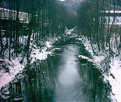 The Weißache in its lower reaches near Kufstein | |
| Location |
Tyrol, |
| Physical characteristics | |
| Main source |
Zinsberggrund in Ellmau rd. 1,600 m (AA) |
| River mouth |
In Kufstein into the Inn ca. 500 m (AA) 47°34′32″N 12°09′14″E / 47.57564°N 12.15378°E |
| Length | 24.2 km (15.0 mi) [1] |
| Basin features | |
| Progression | Inn→ Danube→ Black Sea |
| Landmarks | Small towns: Söll, Kufstein |
The Weißache is a river in the Söllandl, a valley between the Kaisergebirge mountains and the Hohe Salve. It rises at about 1,600 m (AA) on the Zinsbergund in the Weißachergraben and discharges in Endach, part of Kufstein, into the Inn.
The Ache flows through the following municipalities (in downstream order):
Before the Eiberg Road branches off to Schwoich the stream is divided and the larger part is pumped under the mountain of the Kufstein Forest into a heat-only boiler station south of Kufsteins and acts as cooling water, before it flows naturally back to the Inn. Between Egerbach in the municipality of Schwoich and Endach in the borough of Kufstein the rest of the Weißache flows for ca. 800 m through a long gully, before it breaks out into the valley and heads northwest towards the Inn. There it is joined by the other half of the Ache around two kilometres after the boiler station.
In 2005 numerous measures were taken in Kufstein to reinforce the banks. The stream has cut ever deeper in recent years which can cause its banks to collapse.