Rott (Inn, Neuhaus am Inn)
| Rott | |
|---|---|
 | |
| Country | Germany |
| Physical characteristics | |
| Main source | Lower Bavaria |
| River mouth |
Inn 48°27′12″N 13°25′32″E / 48.45333°N 13.42556°ECoordinates: 48°27′12″N 13°25′32″E / 48.45333°N 13.42556°E |
| Length | 111.4 km (69.2 mi) [1] |
| Basin features | |
| Progression | Inn→ Danube→ Black Sea |
| Basin size | 1,200 km2 (460 sq mi) [1] |
The Rott is a 111 km long river in Bavaria, Germany, left tributary of the Inn. Its source is in the municipality Wurmsham in Lower Bavaria, between Landshut and Waldkraiburg. It flows east through a rural area with small towns, including Neumarkt-Sankt Veit, Eggenfelden, Pfarrkirchen and Pocking. It flows into the Inn opposite Schärding, on the border with Austria.
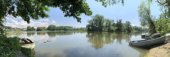
Confluence of Rott (from the right) and Inn
References
- 1 2 Complete table of the Bavarian Waterbody Register by the Bavarian State Office for the Environment (xls, 10.3 MB)
This article is issued from
Wikipedia.
The text is licensed under Creative Commons - Attribution - Sharealike.
Additional terms may apply for the media files.