Murn (river)
| Murn | |
|---|---|
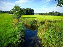 The confluence of the Surbrunner Bach (from the left side) and the Surerbach (from the right side) | |
| Other name(s) | Murnbach |
| Physical characteristics | |
| Main source | Kirchensur |
| River mouth |
Inn 47°58′38″N 12°09′10″E / 47.97717°N 12.15277°ECoordinates: 47°58′38″N 12°09′10″E / 47.97717°N 12.15277°E |
| Length | 39.6 km (24.6 mi) [1] |
| Basin features | |
| Progression | Inn→ Danube→ Black Sea |
| Basin size | 179.14 km2 (69.17 sq mi) [1][2] |
The Murn is a river in Bavaria, Germany, and a right tributary of the river Inn.
Name
The name "Murn" comes from the Bavarian word Mur (sand) and could be translated as "sand stream". Murn is a feminine word in German ("Die Murn").[3]
Geography
The source of the Murn is the confluence of the two brooks Surerbach and Surbrunner Bach near Kirchensur, Landkreis Rosenheim. It starts to flow southward with the name Murnbach (German Bach means "brook") and is named Murn with increasing width. It changes direction several times until it finally flows northward into the Inn near Obermühl in the municipality of Griesstätt.[4]
References
- 1 2 Complete table of the Bavarian Waterbody Register by the Bavarian State Office for the Environment (xls, 10.3 MB)
- ↑ "Kartendienst Gewässerbewirtschaftung, FGN" (in German). Bayerisches Landesamt für Umwelt.
- ↑ Greule, Albrecht (2014). Deutsches Gewässernamenbuch: Etymologie der Gewässernamen und der zugehörigen Gebiets-, Siedlungs- und Flurnamen. p. 364 – via Google Books.
- ↑ "BayernAtlas (mapping service of the Bavarian government)".
This article is issued from
Wikipedia.
The text is licensed under Creative Commons - Attribution - Sharealike.
Additional terms may apply for the media files.