Ziller
| Ziller | |
|---|---|
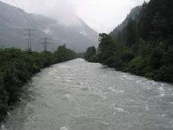 Ziller near Mayrhofen. | |
| Country | Austria, Tyrol |
| Physical characteristics | |
| Main source | Zillertal Alps |
| River mouth |
Inn 47°24′25″N 11°50′14″E / 47.4070°N 11.8372°ECoordinates: 47°24′25″N 11°50′14″E / 47.4070°N 11.8372°E |
| Length | 55.7 km (34.6 mi) [1] |
| Basin features | |
| Progression | Inn→ Danube→ Black Sea |
| Basin size | 1,135 km2 (438 sq mi) [1] |
The Ziller is a right-side tributary to the Inn, in the Zillertal in Tyrol, Austria. It is 55.7 km (34.6 mi) long, and its basin area is 1,135 km2 (438 sq mi).[1] It springs from the ridge of the Zillertal Alps, and feeds the Zillergründl Dam. In Mayrhofen it receives the Zemmbach (that in turn receives the Tuxerbach). By Zell am Ziller it receives the Gerlosbach, before it flows into the Inn by Strass im Zillertal.
For historical reasons, the Ziller for most of its course makes up the border between the Diocese of Innsbruck on the west and the Archdiocese of Salzburg on the east. The Ziller today shows a good presence of brown- and rainbow trout, as well as grayling. It is up to 20 m wide and 2 m deep, and it has an average discharge of 43.1 m³/s.
References