History of geodesy
| Geodesy | ||||||||||||||||||||||||||
|---|---|---|---|---|---|---|---|---|---|---|---|---|---|---|---|---|---|---|---|---|---|---|---|---|---|---|
 | ||||||||||||||||||||||||||
| Fundamentals | ||||||||||||||||||||||||||
| Concepts | ||||||||||||||||||||||||||
| Technologies | ||||||||||||||||||||||||||
| Standards (History) | ||||||||||||||||||||||||||
|
||||||||||||||||||||||||||
Geodesy (/dʒiːˈɒdɨsi/), also named geodetics, is the scientific discipline that deals with the measurement and representation of the Earth. The history of geodesy began in pre-scientific antiquity and blossomed during the Age of Enlightenment.
Early ideas about the figure of the Earth held the Earth to be flat (see flat Earth), and the heavens a physical dome spanning over it. Two early arguments for a spherical Earth were that lunar eclipses were seen as circular shadows which could only be caused by a spherical Earth, and that Polaris is seen lower in the sky as one travels South.
Hellenic world
The early Greeks, in their speculation and theorizing, ranged from the flat disc advocated by Homer to the spherical body postulated by Pythagoras. Pythagoras's idea was supported later by Aristotle.[2] Pythagoras was a mathematician and to him the most perfect figure was a sphere. He reasoned that the gods would create a perfect figure and therefore the Earth was created to be spherical in shape. Anaximenes, an early Greek philosopher, believed strongly that the Earth was rectangular in shape.
Since the spherical shape was the most widely supported during the Greek Era, efforts to determine its size followed. Aristotle reported that mathematicians had calculated the circumference of the Earth (which is slightly over 40,000 km) to be 400,000 stadia (between 62,800 and 74,000 km or 46,250 and 39,250 mi) while Archimedes stated an upper bound of 3,000,000 stadia (483,000 km or 300,000 mi) using the Hellenic stadion which scholars generally take to be 185 meters or 1⁄9 of a geographical mile.
Hellenistic world
In Egypt, a Greek scholar and philosopher, Eratosthenes (276 BCE – 195 BCE), devised a method for a more explicit measurement of the earth's size. Reports from the ancient city of Swenett, later known as Syene, stated that on the day of the summer solstice, the midday sun shone to the bottom of a well. He observed in Alexandria, that the sun was not directly overhead. Instead, it cast a shadow with the vertical equal to 1/50th of a circle (7° 12'). To these observations, Hellenistic Astronomy and knowledge of the local geography had already established that; (1) on the day of the summer solstice, the midday sun was directly over the Tropic of Cancer; (2) Syene was on this tropic; (3) Alexandria and Syene lay on a direct north-south line; (4) The sun was a relatively long way away (which would later be known as the astronomical unit). He determined that distance between Alexandria and Syene was 5000 stadia, (possibly by having hired someone to walk and measure the distance, but more likely using reports of travelers of the distance) or at the usual Hellenic 185 m per stadion, about 925 km.
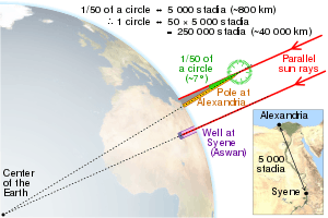
From these observations, measurements, and/or "known" facts, Eratosthenes concluded that since the angular deviation of the sun from the vertical direction at Alexandria was also the angle of the subtended arc (see illustration), the linear distance between Alexandria and Syene was 1/50 of the circumference of the Earth which thus must be 50×5000 = 250,000 stadia or probably 25,000 geographical miles. The circumference of the Earth is 24,902 mi (40,075.16 km). Over the poles it is more precisely 40,008 km or 24,860 mi. The actual unit of measure used by Eratosthenes was the stadion. No one knows for sure what his stadion equals in modern units, possibly it was the Hellenic 185 m stadion.
Had the experiment been carried out as described, it would not be remarkable if it agreed with actuality. What is remarkable is that the result was probably only about 0.4% too high. His measurements were subject to several inaccuracies: (1) though at the summer solstice the noon sun is overhead at the Tropic of Cancer, Syene was not exactly on the tropic (which was at 23° 43' latitude in that day) but about 22 geographical miles to the north; (2) the difference of latitude between Alexandria (31.2 degrees north latitude) and Syene (24.1 degrees) is really 7.1 degrees rather than the perhaps rounded (1/50 of a circle) value of 7° 12' that Eratosthenes used; (3) the actual solstice zenith distance of the noon sun at Alexandria was 31° 12' − 23° 43' = 7° 29' or about 1/48 of a circle not 1/50 = 7° 12', an error closely consistent with use of a vertical gnomon which fixes not the sun's center but the solar upper limb 16' higher; (4) the most importantly flawed element, whether he measured or adopted it, was the latitudinal distance from Alexandria to Syene (or the true Tropic somewhat further south) which appears to have caused the overestimate that relates to most of the error in his resulting circumference of the earth.
A parallel later ancient measurement of the size of the Earth was made by another Greek scholar, Posidonius. He noted that the star Canopus was hidden from view in most parts of Greece but that it just grazed the horizon at Rhodes. Posidonius is supposed to have measured the angular elevation of Canopus at Alexandria and determined that the angle was 1/48 of circle. He used a distance from Alexandria to Rhodes, 5000 stadia, and so he computed the Earth's circumference in stadia as 48 times 5000 = 240,000.[3] Some scholars see these results as luckily semi-accurate due to cancellation of errors. But since the Canopus observations are both mistaken by over a degree, the "experiment" may be not much more than a recycling of Eratosthenes's numbers, while altering 1/50 to the correct 1/48 of a circle. Later, either he or a follower appears to have altered the base distance to agree with Eratosthenes's Alexandria-to-Rhodes figure of 3750 stadia since Posidonius's final circumference was 180,000 stadia, which equals 48×3750 stadia.[4] The 180,000 stadia circumference of Posidonius is suspiciously close to that which results from another method of measuring the earth, by timing ocean sunsets from different heights, a method which is inaccurate due to horizontal atmospheric refraction.
The abovementioned larger and smaller sizes of the Earth were those used by Claudius Ptolemy at different times, 252,000 stadia in his Almagest and 180,000 stadia in his later Geography. His midcareer conversion resulted in the latter work's systematic exaggeration of degree longitudes in the Mediterranean by a factor close to the ratio of the two seriously differing sizes discussed here, which indicates [5] that the conventional size of the earth was what changed, not the stadion.
Ancient India
The Indian mathematician Aryabhata (AD 476–550) was a pioneer of mathematical astronomy. He describes the earth as being spherical and that it rotates on its axis, among other things in his work Āryabhaṭīya. Aryabhatiya is divided into four sections. Gitika, Ganitha (mathematics), Kalakriya (reckoning of time) and Gola (celestial sphere). The discovery that the earth rotates on its own axis from west to east is described in Aryabhatiya (Gitika 3,6; Kalakriya 5; Gola 9,10;).[6] For example, he explained the apparent motion of heavenly bodies is only an illusion (Gola 9), with the following simile;
- Just as a passenger in a boat moving downstream sees the stationary (trees on the river banks) as traversing upstream, so does an observer on earth see the fixed stars as moving towards the west at exactly the same speed (at which the earth moves from west to east.)
Aryabhatiya also estimates the circumference of Earth, with an error of less than 1%. He gave the circumference of the earth as 4 967 yojanas and its diameter as 1 5811/24 yojanas. Since 1 yojana = 5 miles this gives the circumference as 24 835 miles, which is an excellent approximation to the currently accepted value of 24 902 miles.[7] Aryabhata gives the radii of the orbits of the planets in terms of the Earth-Sun distance as essentially their periods of rotation around the Sun. He also gave the correct explanation of lunar and solar eclipses and that the Moon shines by reflecting sunlight.[6]
Islamic world
The Muslim scholars, who held to the spherical Earth theory, used it to calculate the distance and direction from any given point on the earth to Mecca. This determined the Qibla, or Muslim direction of prayer. Muslim mathematicians developed spherical trigonometry which was used in these calculations.[8]
Around AD 830 Caliph al-Ma'mun commissioned a group of astronomers led by Al-Khwarizmi to measure the distance from Tadmur (Palmyra) to Raqqa, in modern Syria. They found the cities to be separated by one degree of latitude and the distance between them to be 662⁄3 miles and thus calculated the Earth's circumference to be 24,000 miles.[9] Another estimate given was 562⁄3 Arabic miles per degree, which corresponds to 111.8 km per degree and a circumference of 40,248 km, very close to the currently modern values of 111.3 km per degree and 40,068 km circumference, respectively.[10]
Muslim astronomers and geographers were aware of magnetic declination by the 15th century, when the Egyptian astronomer 'Abd al-'Aziz al-Wafa'i (d. 1469/1471) measured it as 7 degrees from Cairo.[11]
Medieval Europe
Revising the figures attributed to Posidonius, another Greek philosopher determined 18,000 miles as the Earth's circumference. This last figure was promulgated by Ptolemy through his world maps. The maps of Ptolemy strongly influenced the cartographers of the Middle Ages. It is probable that Christopher Columbus, using such maps, was led to believe that Asia was only 3 or 4 thousand miles west of Europe.
Ptolemy's view was not universal, however, and chapter 20 of Mandeville's Travels (c. 1357) supports Eratosthenes' calculation.
It was not until the 16th century that his concept of the Earth's size was revised. During that period the Flemish cartographer, Mercator, made successive reductions in the size of the Mediterranean Sea and all of Europe which had the effect of increasing the size of the earth.
Early modern period
The invention of the telescope and the theodolite and the development of logarithm tables allowed exact triangulation and grade measurement.
Europe
In 1505 the cosmographer and explorer Duarte Pacheco Pereira calculated the value of the degree of the meridian arc with a margin of error of only 4%, when the current error at the time varied between 7 and 15%.[12]
Jean Picard performed the first modern meridian arc measurement in 1669–1670. He measured a baseline using wooden rods, a telescope (for his angular measurements), and logarithms (for computation). Jacques Cassini later continued Picard's arc (Paris meridian arc) northward to Dunkirk and southward to the Spanish border. Cassini divided the measured arc into two parts, one northward from Paris, another southward. When he computed the length of a degree from both chains, he found that the length of one degree of latitude in the northern part of the chain was shorter than that in the southern part (see illustration).

This result, if correct, meant that the earth was not a sphere, but a prolate spheroid (taller than wide). However, this contradicted computations by Isaac Newton and Christiaan Huygens. In 1659, Christiaan Huygens was the first to derive the now standard formula for the centripetal force in his work De vi centrifuga. The formula played a central role in classical mechanics and became known as the second of Newton's laws of motion. Newton's theory of gravitation combined with the rotation of the Earth predicted the Earth to be an oblate spheroid (wider than tall), with a flattening of 1:230.[13]
The issue could be settled by measuring, for a number of points on earth, the relationship between their distance (in north-south direction) and the angles between their zeniths. On an oblate Earth, the meridional distance corresponding to one degree of latitude will grow toward the poles, as can be demonstrated mathematically.
The French Academy of Sciences dispatched two expeditions. One expedition (1736–37) under Pierre Louis Maupertuis was sent to Torne Valley (near the Earth's northern pole). The second mission (1735–44) under Pierre Bouguer was sent to what is modern-day Ecuador, near the equator. Their measurements demonstrated an oblate Earth, with a flattening of 1:210. This approximation to the true shape of the Earth became the new reference ellipsoid.
In 1787 the first precise trigonometric survey to be undertaken within Britain was the Anglo-French Survey. Its purpose was to link the Greenwich and Paris' observatories.[14] The survey is very significant as the forerunner of the work of the Ordnance Survey which was founded in 1791, one year after William Roy's death.
Between 1792 and 1798 Pierre Méchain and Jean-Baptiste Delambre surveyed the Paris meridian arc between Dunkirk and Barcelona. They extrapolated from this measurement the distance from the North Pole to the Equator which was 5 130 740 toises. As the metre had to be equal to one ten-million of this distance, it was defined as 0,513074 toises or 443,296 lignes of the Toise of Peru (see below).[15]
Asia and Americas
In South America Bouguer noticed, as did George Everest in the 19th century Great Trigonometric Survey of India, that the astronomical vertical tended to be pulled in the direction of large mountain ranges, due to the gravitational attraction of these huge piles of rock. As this vertical is everywhere perpendicular to the idealized surface of mean sea level, or the geoid, this means that the figure of the Earth is even more irregular than an ellipsoid of revolution. Thus the study of the "undulation of the geoid" became the next great undertaking in the science of studying the figure of the Earth.
19th century
In the late 19th century the Mitteleuropäische Gradmessung (Central European Arc Measurement) was established by several central European countries and a Central Bureau was set up at the expense of Prussia, within the Geodetic Institute at Berlin.[16] One of its most important goals was the derivation of an international ellipsoid and a gravity formula which should be optimal not only for Europe but also for the whole world. The Mitteleuropäische Gradmessung was an early predecessor of the International Association of Geodesy (IAG) one of the constituent sections of the International Union of Geodesy and Geophysics (IUGG) which was founded in 1919.[17][18]
Geodesy and standards of length
In 1811 Ferdinand Rudolph Hassler was selected to direct the U. S. coast survey, and sent on a mission to France and England to procure instruments and standards of measurement.[19] The unit of length to which all distances measured in the U. S. coast survey were referred is the French metre, of which Ferdinand Rudolph Hassler had brougth a copy in the United States in 1805.[20][21]
In the early 19th century, the Paris meridian's arc was recalculated with greater precision between Shetland and the Balearic Islands by the French astronomers François Arago and Jean-Baptiste Biot. In 1821 they published their work as a fourth volume following the three volumes of "Bases du système métrique décimal ou mesure de l'arc méridien compris entre les parallèles de Dunkerque et Barcelone" (Basis for the decimal metric system or measurement of the meridian arc comprised between Dunkirk and Barcelona) by Delambre and Méchain.[22]
In 1860, the Russian Government at the instance of Otto Sturves invited the Governments of Belgium, France, Prussia and England to connect their triangulations in order to measure the length of an arc of parallel in latitude 52° and to test the accuracy of the figure and dimensions of the Earth, as derived from the measurements of arc of meridian. In order to combine the measurements, it was necessary to compare the geodetic standards of length used in the different countries. The British Government invited those of France, Belgium, Prussia, Russia, India, Australia, Austria, Spain, United States and Cape of Good Hope to send their standards to the Ordnance Survey office in Southampton. Notably the standards of France, Spain and United States were based on the metric system, whereas those of Prussia, Belgium and Russia where calibrated against the toise, of which the oldest physical representative was the Toise of Peru. The Toise of Peru had been constructed in 1735 for Bouguer and De La Condamine as their standard of reference in the French Geodesic Mission, conducted in actual Ecuador from 1735 to 1744 in collaboration with the Spanish officers Jorge Juan and Antonio de Ulloa.
Alexander Ross Clarke and Henry James published the first results of the standards' comparisons in 1867. The same year Russia, Spain and Portugal joined the "Europäische Gradmessung" and the General Conference of the association proposed the metre as a uniform length standard for the Arc Measurement and recommended the establishment of an International Bureau of Weights and Measures.
The Europäische Gradmessung decided the creation of an international geodetic standard at the General Conference held in Paris in 1875. The Metre Convention was signed in 1875 in Paris and the International Bureau of Weights and Measures was created under the supervision of the International Committee for Weights and Measures. The first president of the International Committee for Weights and Measures was the Spanish geodesist Carlos Ibáñez e Ibáñez de Ibero. He also was the president of the Permanent Commission of the "Europäische Gradmessung" from 1874 to 1886. In 1886 the association changed name for the International Geodetic Association and Carlos Ibáñez e Ibáñez de Ibero was reelected as president. He remained in this position until his death in 1891. During this period the International Geodetic Association gained worldwide importance with the joining of United States, Mexico, Chile, Argentina and Japan. In 1883 the General Conference of the "Europäische Gradmessung" proposed to select the Greenwich meridian as the prime meridian in the hope that Great Britain would accede to the Metre Convention.
Geodesy and mathematics
Most of the relevant theories were derived by the German geodesist Friedrich Robert Helmert in his famous books Die mathematischen und physikalischen Theorieen der höheren Geodäsie, Einleitung und 1. Teil (1880) and 2. Teil (1884); English translation: Mathematical and Physical Theories of Higher Geodesy, Vol. 1 and Vol. 2. Helmert also derived the first global ellipsoid in 1906 with an accuracy of 100 meters (0.002 percent of the Earth's radii). The US geodesist Hayford derived a global ellipsoid in ~1910, based on intercontinental isostasy and an accuracy of 200 m. It was adopted by the IUGG as "international ellipsoid 1924".
See also
Notes
- ↑ NASA/Goddard Space Flight Center (3 February 2012). Looking Down a Well: A Brief History of Geodesy (digital animation). NASA/Goddard Space Flight Center. Goddard Multimedia Animation Number: 10910. Archived from the original (OGV) on 3 February 2012. Retrieved 6 February 2014.
- ↑ Aristotle On the Heavens, Book II 298 B
- ↑ Cleomedes 1.10
- ↑ Strabo 2.2.2, 2.5.24; D.Rawlins, Contributions
- ↑ D.Rawlins (2007). "Investigations of the Geographical Directory 1979–2007 "; DIO Archived 2008-03-06 at the Wayback Machine., volume 6, number 1, page 11, note 47, 1996.
- 1 2 http://www.ias.ac.in/resonance/march2006/p51-68.pdf
- ↑ "Aryabhata the Elder".
- ↑ David A. King, Astronomy in the Service of Islam, (Aldershot (U.K.): Variorum), 1993.
- ↑ Gharā'ib al-funūn wa-mulah al-`uyūn (The Book of Curiosities of the Sciences and Marvels for the Eyes), 2.1 "On the mensuration of the Earth and its division into seven climes, as related by Ptolemy and others," (ff. 22b–23a)
- ↑ Edward S. Kennedy, Mathematical Geography, pp. 187–8, in (Rashed & Morelon 1996, pp. 185–201)
- ↑ Barmore, Frank E. (April 1985), "Turkish Mosque Orientation and the Secular Variation of the Magnetic Declination", Journal of Near Eastern Studies, University of Chicago Press, 44 (2): 81–98 [98], doi:10.1086/373112
- ↑ Universidade de São Paulo, Departamento de História, Sociedade de Estudos Históricos (Brazil), Revista de História (1965), ed. 61-64, p. 350
- ↑ Paul., Murdin, (2009). Full meridian of glory : perilous adventures in the competition to measure the Earth. New York: Copernicus Books/Springer. pp. 39–75. ISBN 9780387755342. OCLC 314175913.
- ↑ Martin, Jean-Pierre; McConnell, Anita (2008-12-20). "Joining the observatories of Paris and Greenwich". Notes and Records of the Royal Society. 62 (4): 355–372. doi:10.1098/rsnr.2008.0029. ISSN 0035-9149.
- ↑ "Histoire du mètre". Wikipédia (in French). 2018-05-26.
- ↑ "A Note on the History of the IAG". IAG Homepage. Retrieved 2017-11-06.
- ↑ "(IAG) International Association of Geodesy: Associations of IUGG". www.iugg.org. Retrieved 2017-11-06.
- ↑ "IUGG, the International Union of Geodesy and Geophysics | Union Geodesique et Geophysique Internationale". www.iugg.org. Retrieved 2017-11-06.
- ↑ Appletons' Cyclopædia of American Biography.
- ↑ Clarke, Alexander Ross; James, Henry (1873-01-01). "XIII. Results of the comparisons of the standards of length of England, Austria, Spain, United States, Cape of Good Hope, and of a second Russian standard, made at the Ordnance Survey Office, Southampton. With a preface and notes on the Greek and Egyptian measures of length by Sir Henry James". Philosophical Transactions of the Royal Society of London. 163: 445–469. doi:10.1098/rstl.1873.0014. ISSN 0261-0523.
- ↑ "e-expo: Ferdinand Rudolf Hassler". www.f-r-hassler.ch. Retrieved 2018-05-29.
- ↑ "ETH-Bibliothek / Base du système métrique... [7]". www.e-rara.ch. Retrieved 2018-05-29.
References
- An early version of this article was taken from the public domain source at http://www.ngs.noaa.gov/PUBS_LIB/Geodesy4Layman/TR80003A.HTM#ZZ4.
- J. L. Greenberg: The problem of the Earth's shape from Newton to Clairaut: the rise of mathematical science in eighteenth-century Paris and the fall of "normal" science. Cambridge : Cambridge University Press, 1995 ISBN 0-521-38541-5
- M .R. Hoare: Quest for the true figure of the Earth: ideas and expeditions in four centuries of geodesy. Burlington, VT: Ashgate, 2004 ISBN 0-7546-5020-0
- D. Rawlins: "Ancient Geodesy: Achievement and Corruption" 1984 (Greenwich Meridian Centenary, published in Vistas in Astronomy, v.28, 255–268, 1985)
- D. Rawlins: "Methods for Measuring the Earth's Size by Determining the Curvature of the Sea" and "Racking the Stade for Eratosthenes", appendices to "The Eratosthenes–Strabo Nile Map. Is It the Earliest Surviving Instance of Spherical Cartography? Did It Supply the 5000 Stades Arc for Eratosthenes' Experiment?", Archive for History of Exact Sciences, v.26, 211–219, 1982
- C. Taisbak: "Posidonius vindicated at all costs? Modern scholarship versus the stoic earth measurer". Centaurus v.18, 253–269, 1974
Further reading
- Isaac Asimov (1972). How Did We Find Out the Earth is Round?. Walker. ISBN 978-0802761217.