Carlos Ibáñez e Ibáñez de Ibero
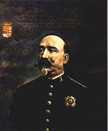
Carlos Ibáñez e Ibáñez de Ibero, 1st Marquis of Mulhacén, (April 14, 1825 - January 28 or 29, 1891) was a Spanish divisional general and geographer.[1] He represented Spain at the 1875 Conference of the Metre Convention and was the first president of the International Committee for Weights and Measures.[2] As a forerunner geodesist and first president of the International Geodetic Association, he played a leading role in the worldwide dissemination of the metric system.[3] His activities resulted in the distribution of a platinum and iridium prototype of the metre to all States parties to the Metre Convention during the first meeting of the General Conference on Weights and Measures in 1889.[2] These prototypes defined the metre right up until 1960.[4]
He was born in Barcelona. According to Spanish tradition, his surname was a combination of his father's first surname, Martín Ibáñez y de Prado and of his mother's first surname, Carmen Ibáñez de Ibero y González del Río. As his parent's surnames were so similar he was often referred as Ibáñez or Ibáñez de Ibero or as Marquis of Mulhacén. When he died in Nice (France), he was still enrolled in the Engineer Corps of the Spanish Army. As he died around midnight, the date of his death is ambiguous, Spaniards retained 28th, and continental Europeans 29 January.[1]
Scientific career
From the Map Commission to the Geographic and Statistical Institute in Spain
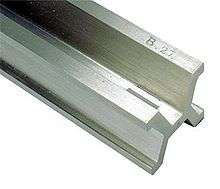
Spain adopted the metric system in 1849. The Government was urged by the Royal Academy of Science to approve the creation of a large-scale map of Spain in 1852.[6] The following year Ibáñez was appointed to undertake this task.[2] All the scientific and technical material had to be created.[2] Ibáñez and Saavedra went to Paris to supervise the production by Brunner of a measuring instrument calibrated against the metre which they had devised and which they later compared with Borda's double-toise N°1 which was the main reference for measuring all geodetic bases in France and whose length was 3.8980732 metres.[7][3][8]
In 1858 Spain's central geodetic base of triangulation was measured in Madridejos (Toledo) with exceptional precision for the time thanks to this instrument, which became known as the Spanish Rod (French: Règle espagnole).[9] Ibáñez and his colleagues wrote a monograph which was translated into French by Aimé Laussedat.[10] The experiment, in which the results of two methods were compared, ended a controversy between French and German geodesists about the length of geodesic triangulation bases, and empirically validated the method of General Johann Jacob Bayer, founder of the International Association of Geodesy.[11]
The Spanish Rod was replicated in order to be used in Egypt. In 1863, Ibáñez and Ismael Effendy compared the Spanish Rod with the Egyptian Rod in Madrid.[12]
From 1865 to 1868 Ibáñez added the survey of the Balearic Islands with that of the Iberian Peninsula.[9] For this work, he devised a new instrument, which allowed much faster measurements.[9] In 1869, Ibáñez went to Southampton to make the necessary measurements to compare the standards of length of England and Spain.[2][8] Finally, this second version of the appliance, called the Ibáñez apparatus, was used in Switzerland to measure the geodetic bases of Aarberg, Weinfelden and Bellinzona.[2]
In 1870 Ibáñez founded the Spanish National Geographic Institute which he then directed until 1889. At the time it was the world's biggest geographic institute.[2] It encompassed geodesy, general topography, leveling, cartography, statistics and the general service of weights and measures.[2]
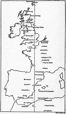
Measurement of the Paris meridian over the Mediterranean Sea
In 1865 the triangulation of Spain was connected with that of Portugal and France.[10] In 1866 at the conference of the Association of Geodesy in Neuchâtel, Ibáñez announced that Spain would collaborate in measuring the Paris meridian.[2] In 1879 Ibáñez and François Perrier (representing France) completed the junction between the geodetic network of Spain and Algeria and thus completed the measurement of the Paris meridian which extended from Shetland to the Sahara.[13] This connection was a remarkable enterprise where triangles with a maximum length of 270 km were observed from mountain stations (Mulhacén, Tetica, Filahoussen, M'Sabiha) over the Mediterranean Sea.[14][13]
International scientific collaboration in geodesy and calls for an international standard unit of length
In 1867 at the second general conference of the International Association of Geodesy held in Berlin, the question of an international standard unit of length was discussed in order to combine the measurements made in different countries to determine the size and shape of the Earth.[15][16][2] The conference recommended the adoption of the metre and the creation of an international metre commission, according to the proposal of Johann Jacob Baeyer, Adolphe Hirsch and Carlos Ibáñez e Ibáñez de Ibero.[2] The French Académie des Sciences and the Bureau des Longitudes in Paris drew the attention of the French government to this issue. The Academy of St Petersburg and the English Standards Commission were in agreement with the recommendation.[15]
In November 1869 the French government issued invitations to join this commission.[15] Spain accepted and Ibáñez took part in the Committee of preparatory research from the first meeting of the International Metre Commission in 1870.[17] He became president of the permanent Committee of the International Metre Commission in 1872.[18] He represented Spain at the 1875 conference of the Metre Convention and at the first General Conference on Weights and Measures in 1889.[2][19] He was the first president of the International Committee for Weights and Measures from 1875 to 1891.[20] He received the Légion d'Honneur in recognition of his efforts to disseminate the metric system among all nations and was awarded the Poncelet Prize for his scientific contribution to metrology.[18][3]
See also
External links

- Excmo. Sr. D. CARLOS IBÁÑEZ E IBÁÑEZ DE IBERO. Académicos Históricos. Real Academia de Ciecias Exactas, Físicas y Naturales.
- Jesús Ildefonso Díaz Díaz, Un Académico del siglo XIX con proyección internacional sin parangón: el General Ibáñez
- Albert Pérard, Carlos IBAÑEZ DE IBERO (14 avril 1825 - 29 janvier 1891), (inauguration d'un monument élevé à sa mémoire), Madrid, Institut de France Académie des Sciences - Notices et discours., 1957, 7 p., p. 26-31
References
- 1 2 "Carlos Ibáñez e Ibáñez de Ibero". Wikipédia (in French). 2017-05-19.
- 1 2 3 4 5 6 7 8 9 10 11 12 Hirsch, Adolphe (1891). "Don Carlos IBANEZ (1825 - 1891)" (PDF). Bureau International des Poids et Mesures. pp. 9, 4, 8, 5, 10, 7, 8–9. Retrieved May 22, 2017.
- 1 2 3 Soler, T. (1997-02-01). "A profile of General Carlos Ibáñez e Ibáñez de Ibero: first president of the International Geodetic Association". Journal of Geodesy. 71 (3): 176–188 pp. 178, 183. doi:10.1007/s001900050086. ISSN 0949-7714.
- ↑ "BIPM - former Prototype Metre". www.bipm.org. Retrieved 2017-05-22.
- ↑ "Earth, Figure of the". 1911 Encyclopædia Britannica. 8.
- ↑ Núñez de las Cuevas, Rodolfo (2005). "Militares y marinos en la Real Sociedad Geográfica" (PDF). Universidad de Navarra. Retrieved May 22, 2017.
- ↑ Brunner, Académie des sciences (France) Auteur du (2017-05-22). Comptes rendus hebdomadaires des séances de l'Académie des sciences / publiés... par MM. les secrétaires perpétuels. Géodésie. - Appareil construit pour les opérations au moyen desquelles on prolongera dans toute l'étendue de l'Espagne le réseau trigonométrique qui couvre la France. Paris: Gauthier-Villars. pp. 150–152.
- 1 2 Clarke, A. R.; James, Henry (1873-01-01). "Results of the Comparisons of the Standards of Length of England, Austria, Spain, United States, Cape of Good Hope, and of a Second Russian Standard, Made at the Ordnance Survey Office, Southampton". Philosophical Transactions of the Royal Society of London. 163: 445–469, p. 16. doi:10.1098/rstl.1873.0014. ISSN 0261-0523.
- 1 2 3 J. Bertrand, Académie des sciences (France) Auteur du (1891-01-01). Comptes rendus hebdomadaires des séances de l'Académie des sciences / publiés... par MM. les secrétaires perpétuels. Notice sur le général Ibañez, correspondant de l'Académie. Paris: Gauthier-Villars. pp. 266–269.
- 1 2 Laussedat, Académie des sciences (France) Auteur du (1866-01-01). Comptes rendus hebdomadaires des séances de l'Académie des sciences / publiés... par MM. les secrétaires perpétuels. Géodésie. - Sur les travaux géodésiques exécutés en Espagne, à propos de la publication d'une traduction de l'ouvrage intitulé : Base centrale de la triangulation géodésique de l'Espagne. Paris: Gauthier-Villars. pp. 1007–1010.
- ↑ Laussedat, Académie des sciences (France) Auteur du (1864-01-01). Comptes rendus hebdomadaires des séances de l'Académie des sciences / publiés... par MM. les secrétaires perpétuels. Géodésie. - Sur les opérations en cours d'exécution pour la carte d'Espagne, d'après les renseignements donnés à l'académie de Madrid par M. le colonel Ibañez. Paris: Gauthier-Villars. pp. 70–72.
- ↑ texte, Académie des sciences (France) Auteur du (1864-07-01). Comptes rendus hebdomadaires des séances de l'Académie des sciences / publiés... par MM. les secrétaires perpétuels. Paris: Gauthier-Villars. p. 623.
- 1 2 Perrier, Académie des sciences (France) Auteur du (1879-07-01). Comptes rendus hebdomadaires des séances de l'Académie des sciences / publiés... par MM. les secrétaires perpétuels. Géodésie. - Jonction géodésique de l'Algérie avec l'Espagne, opération internationale exécutée sous la direction de MM. le général Ibañez et F. Perrier. Paris: Gauthier-Villars. pp. 885–889.
- ↑ Torge, Wolfgang (2015). IAG 150 Years. Springer, Cham. pp. 3–18. doi:10.1007/1345_2015_42.
- 1 2 3 "BIPM - International Metre Commission". www.bipm.org. Retrieved 2017-05-22.
- ↑ "A Note on the History of the IAG". IAG Homepage. Retrieved 2017-05-26.
- ↑ Morin, Académie des sciences (France) Auteur du (1870-07-01). Comptes rendus hebdomadaires des séances de l'Académie des sciences / publiés... par MM. les secrétaires perpétuels. Métrologie. - Notes sur la première session de la Commission internationale du mètre, tenue à Paris du 8 au 13 août 1870. Paris: Gauthier-Villars. pp. 381–383.
- 1 2 Pérard, Albert (1957). "Carlos IBAÑEZ DE IBERO (14 avril 1825 - 29 janvier 1891), par Albert Pérard (inauguration d'un monument élevé à sa mémoire)" (PDF). Institut de France Académie des Sciences. Archived from the original on May 18, 2017. Retrieved May 22, 2017.
- ↑ "Compte rendu des séances de la première conférence générale des poids et mesures, réunie à Paris en 1889" (PDF). Bureau International des Poids et Mesures. 1890. p. 5. Retrieved May 24, 2017.
- ↑ "BIPM - Presidents of the CIPM". www.bipm.org. Retrieved 2017-05-22.