Ameland
| Ameland It Amelân | |||
|---|---|---|---|
| Municipality | |||
     | |||
| |||
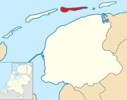 Location in Friesland | |||
| Coordinates: 53°27′N 5°46′E / 53.450°N 5.767°ECoordinates: 53°27′N 5°46′E / 53.450°N 5.767°E | |||
| Country | Netherlands | ||
| Province | Friesland | ||
| Government[1] | |||
| • Body | Municipal council | ||
| • Mayor | Albert de Hoop (D66) | ||
| Area[2] | |||
| • Total | 268.50 km2 (103.67 sq mi) | ||
| • Land | 58.83 km2 (22.71 sq mi) | ||
| • Water | 209.67 km2 (80.95 sq mi) | ||
| Elevation[3] | 4 m (13 ft) | ||
| Population (August 2017)[4] | |||
| • Total | 3,683 | ||
| • Density | 63/km2 (160/sq mi) | ||
| Demonym(s) | Amelander | ||
| Time zone | UTC+1 (CET) | ||
| • Summer (DST) | UTC+2 (CEST) | ||
| Postcode | 9160–9164 | ||
| Area code | 0519 | ||
| Website |
www | ||
| Official name | Duinen Ameland | ||
| Designated | 29 August 2000 | ||
| Reference no. | 2212[5] | ||

Ameland (Dutch pronunciation: [ˈaːməlɑnt] (![]()
Ameland is, counted from the west, the fourth inhabited Dutch Wadden island and belongs to the Friesland/Fryslan province. The whole island falls under one municipality, which carries the same name. The Wadden islands form the border between the North Sea and the Wadden Sea, which lies on the south side of the island file. The municipality of Ameland had a population of 3,683 in 2017. The inhabitants are called Amelanders.
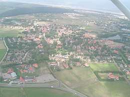
Places
The island has four villages, and one small part-village.
There were two other villages: Oerd and Sier, but these were flooded and now lie in the sea. The name of these villages live on in MS Oerd and MS Sier, which are the names of the ferries to the island. From west to east:
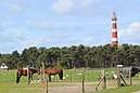
- Hollum, the most populated village, located on the west coast, home to the island's lighthouse
- Ballum, smallest village, location of the island's airfield, Ameland Airport
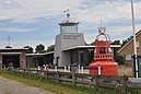
- Nes, the second largest of the island, a vibrant tourist village with many hotels, also home to Burgemeester Waldaschool (the island's secondary school),[6] and ferry services from Holwerd mainland
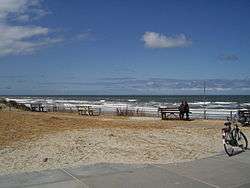
- Buren, located at the centre of the island, includes Ameland's beach
Population
The population of each village of the island as of 2017:
| Name | Population |
| Hollum | 1165 |
| Nes | 1155 |
| Buren | 715 |
| Ballum | 350 |
History
First mentioned as Ambla in the eighth century, it paid tribute to the county of Holland until in 1424 its lord, Ritske Jelmera, declared it a "free lordship" (vrijheerschap).
Although Holland, Friesland and the Holy Roman Emperor contested this quasi-independent status, it remained a free lordship until the ruling family, Cammingha, died out in 1708. After that, the Frisian stadtholder John William Friso, Prince of Orange, became lord of Ameland and after him, his son the stadtholder of all the Netherlands, William IV, Prince of Orange, and his grandson, William V, Prince of Orange.
Only in the constitution of 1813 was the island finally integrated into the Netherlands into the province of Friesland. The monarchy of the Netherlands still maintain the title Vrijheer van Ameland today.
In 1871 and 1872, a dike was built between Ameland and the mainland by a society for the reclamation of Frisian land from the sea. The dike ran from Holwerd to Buren and was 8.7 km (5 mi). long. The province and the Dutch realm each paid 200,000 guilders. In the end, it was unsuccessful; the dike did not prove to be durable and in 1882, after heavy storms in the winter, repair and maintenance of the dam were stopped. The dike can still be partially seen at low tide. The dam at Holwerd is the beginning of this dike.
In 1940 German troops were ferried to the island and within hours Ameland was under the control of the German Army. Because of its limited military value the Allies never invaded Ameland. The German forces on the island did not surrender until June 2, 1945, almost a full month after the defeat of Nazi Germany.
Nature
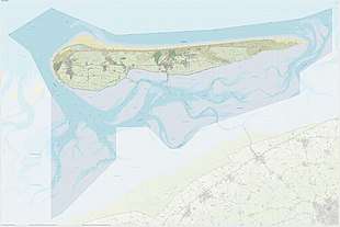
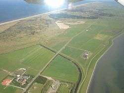
Like all West and East Frisian Islands, Ameland is a unique piece of nature. The profusion of different plants on the island is caused by the immense variety of landscapes. One of the scenic areas is the Oerd, a large complex of dunes which is still expanding by the year. Because of the differing landscapes and types of flora, over 60 different species of birds are sitting there every year. At the eastern part of the Oerd lies a beach plain called the Hon. Besides dunes and beaches, Ameland has some woods, like the Nesser bos ("Wood of Nes").
Transport
Most travelers reach the island by ferry from Holwerd in the mainland of Friesland, but there is also an Airport near Ballum (Ameland Airport). A bus service connects the ferries from Hollum/Ballum (route 130) and Buren/Nes (route 132). When the sea between Friesland and Ameland is low tide one can walk across (see mudflat hiking).
Notable people
The following people were born on Ameland:
- Hannes de Boer (1899–1982), long jumper
- Jan Bruin (1969), footballer
- Willem Cornelis de Groot (1853–1939), architect
- Johannes cardinal de Jong (1885–1955), archbishop of Utrecht
- Sjoerd Soeters (1947), architect
References
- ↑ "College van B&W" [Board of mayor and aldermen] (in Dutch). Gemeente Ameland. Retrieved 7 September 2013.
- ↑ "Kerncijfers wijken en buurten" [Key figures for neighbourhoods]. CBS Statline (in Dutch). CBS. 2 July 2013. Retrieved 12 March 2014.
- ↑ "Postcodetool for 9163HD". Actueel Hoogtebestand Nederland (in Dutch). Het Waterschapshuis. Archived from the original on 21 September 2013. Retrieved 7 September 2013.
- ↑ "Bevolkingsontwikkeling; regio per maand" [Population growth; regions per month]. CBS Statline (in Dutch). CBS. 27 October 2017. Retrieved 27 October 2017.
- ↑ "Duinen Ameland". Ramsar Sites Information Service. Retrieved 25 April 2018.
- ↑ "Burgemeester Waldaschool". BWS Ameland.
External links
| Wikimedia Commons has media related to Ameland. |

- Official website
- The history of Ameland
Places adjacent to Ameland | |
|---|---|
Municipalities of Friesland | ||
|---|---|---|
 | ||
| ||
| West Frisian Islands (Netherlands) |
|  | |||||
|---|---|---|---|---|---|---|---|
| East Frisian Islands (Germany) |
| ||||||
| Heligoland Bight (Germany) | |||||||
| North Frisian Islands (Germany) |
| ||||||
| Danish Wadden Sea Islands (Denmark) |
| ||||||