Opsterland
| Opsterland Opsterlân | |||
|---|---|---|---|
| Municipality | |||
 Former court in Beetsterzwaag | |||
| |||
.svg.png) Location in Friesland | |||
| Coordinates: 53°4′N 6°5′E / 53.067°N 6.083°ECoordinates: 53°4′N 6°5′E / 53.067°N 6.083°E | |||
| Country | Netherlands | ||
| Province | Friesland | ||
| Government[1] | |||
| • Body | Municipal council | ||
| • Mayor | Ellen van Selm (D66) | ||
| Area[2] | |||
| • Total | 227.64 km2 (87.89 sq mi) | ||
| • Land | 224.63 km2 (86.73 sq mi) | ||
| • Water | 3.01 km2 (1.16 sq mi) | ||
| Elevation[3] | 3 m (10 ft) | ||
| Population (August 2017)[4] | |||
| • Total | 29,769 | ||
| • Density | 133/km2 (340/sq mi) | ||
| Time zone | UTC+1 (CET) | ||
| • Summer (DST) | UTC+2 (CEST) | ||
| Postcode | 8400–8409, 9240–9249 | ||
| Area code | 0512, 0513, 0516 | ||
| Website |
www | ||


Opsterland (Dutch pronunciation: [ˈɔpstərlɑnt] (![]()
Population centres
- Bakkeveen
- Beetsterzwaag
- Frieschepalen
- Gorredijk
- Hemrik
- Jonkerslân
- Langezwaag
- Lippenhuizen
- Luxwoude
- Nij Beets
- Olterterp
- Siegerswoude
- Terwispel
- Tijnje
- Ureterp
- Wijnjewoude
Topography
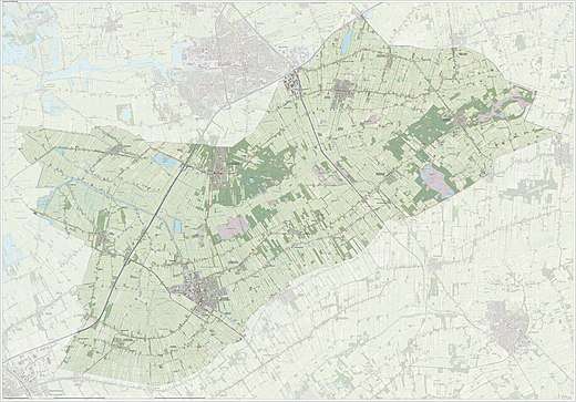
Dutch Topographic map of the municipality of Opsterland, June 2015
International relations
Twin towns — sister cities
Opsterland is twinned with:

- The choice of twinning with both an Israeli city and a Palestinian one is Opsterland's modest contribution to trying to solve the Israeli-Palestinian Conflict. As well as bilateral contacts with both of their partners, the Dutch officials try to encourage trilateral meetings and induce greater contact between Ra'anana and Beit Sahour, which are located at a short geographical distance from each other but are separated by conflict and mutual mistrust. Recently Francisca Ravestein, Nahum Hofree, Hani Al-Hayik - the mayors, respectively, of Opsterland, Ra'anana and Beit Sahour - jointly inaugurated a photo exhibition at the municipal building in Opsterland.[7]
References
- Notes
- ↑ "Burgemeester Francisca Ravestein" [Mayor Elma van Selm] (in Dutch). Gemeente Opsterland. Archived from the original on 27 September 2013. Retrieved 23 September 2013.
- ↑ "Kerncijfers wijken en buurten" [Key figures for neighbourhoods]. CBS Statline (in Dutch). CBS. 2 July 2013. Retrieved 12 March 2014.
- ↑ "Postcodetool for 9244CR". Actueel Hoogtebestand Nederland (in Dutch). Het Waterschapshuis. Retrieved 23 September 2013.
- ↑ "Bevolkingsontwikkeling; regio per maand" [Population growth; regions per month]. CBS Statline (in Dutch). CBS. 27 October 2017. Retrieved 27 October 2017.
- ↑ "Stedenband Opsterland-Ra'anana" [City Connection Opsterland-Ra'anana]. Stedenbanden.nl. Archived from the original on 2011-07-24.
Vanaf 1960 onderhoudt de gemeente Opsterland contacten met de gemeente Ra'anana. Deze contacten zijn in 1963 officieel vastgelegd in een 'vriendschapsverdrag'. In maart 2000 is een delegatie naar Ra'anana gereisd om te praten over een meer themagerichte invulling van het verdrag.
- ↑ "Ra'anana: Twin towns & Sister cities - Friends around the World". raanana.muni.il. Archived from the original on 28 February 2010. Retrieved 24 March 2010.
- ↑
External links

- Official website
Places adjacent to Opsterland | ||||||||||
|---|---|---|---|---|---|---|---|---|---|---|
| ||||||||||
Municipalities of Friesland | ||
|---|---|---|
 | ||
| ||
This article is issued from
Wikipedia.
The text is licensed under Creative Commons - Attribution - Sharealike.
Additional terms may apply for the media files.