Ferwerderadiel
| Ferwerderadiel Ferwerderadeel | |||
|---|---|---|---|
| Municipality | |||
 Canal through Burdaard | |||
| |||
.svg.png) Location in Friesland | |||
| Coordinates: 53°20′N 5°50′E / 53.333°N 5.833°ECoordinates: 53°20′N 5°50′E / 53.333°N 5.833°E | |||
| Country | Netherlands | ||
| Province | Friesland | ||
| Government | |||
| • Body | Municipal council | ||
| • Mayor | Wil van den Berg (CDA) | ||
| Area[1] | |||
| • Total | 133.18 km2 (51.42 sq mi) | ||
| • Land | 97.71 km2 (37.73 sq mi) | ||
| • Water | 35.47 km2 (13.70 sq mi) | ||
| Elevation[2] | 1 m (3 ft) | ||
| Population (August 2017)[3] | |||
| • Total | 8,699 | ||
| • Density | 89/km2 (230/sq mi) | ||
| Time zone | UTC+1 (CET) | ||
| • Summer (DST) | UTC+2 (CEST) | ||
| Postcode | 9070–9179 | ||
| Area code | 0518, 0519, 058 | ||
| Website |
www | ||


Ferwerderadiel (![]()
Population centres
Bartlehiem, Blije, Burdaard, Ferwert, Ginnum, Hallum, Hegebeintum, Jannum, Jislum, Lichtaard, Marrum, Reitsum, Wânswert, Westernijtsjerk.
Topography

'Dutch topographic map of the municipality of Ferwerderadiel, June 2015
Gallery
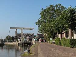 Birdaard, drawbridge and church
 Ferwerd, Vrijhof and church
 Marrum, church
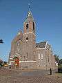 Hallum, church
References
- ↑ "Kerncijfers wijken en buurten" [Key figures for neighbourhoods]. CBS Statline (in Dutch). CBS. 2 July 2013. Retrieved 12 March 2014.
- ↑ "Postcodetool for 9172PJ". Actueel Hoogtebestand Nederland (in Dutch). Het Waterschapshuis. Archived from the original on 21 September 2013. Retrieved 8 September 2013.
- ↑ "Bevolkingsontwikkeling; regio per maand" [Population growth; regions per month]. CBS Statline (in Dutch). CBS. 27 October 2017. Retrieved 27 October 2017.
External links

- Official website
Places adjacent to Ferwerderadiel | |
|---|---|
Municipalities of Friesland | ||
|---|---|---|
 | ||
| ||
This article is issued from
Wikipedia.
The text is licensed under Creative Commons - Attribution - Sharealike.
Additional terms may apply for the media files.