Harlingen, Netherlands
| Harlingen West Frisian: Harns | |||
|---|---|---|---|
| Municipality | |||
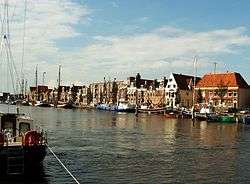 Zuiderhaven harbour, Harlingen | |||
| |||
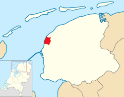 Location in Friesland | |||
| Coordinates: 53°11′N 5°25′E / 53.183°N 5.417°ECoordinates: 53°11′N 5°25′E / 53.183°N 5.417°E | |||
| Country | Netherlands | ||
| Province | Friesland | ||
| Government[1] | |||
| • Body | Municipal council | ||
| • Mayor | Roel Sluiter (PvdA) | ||
| Area[2] | |||
| • Total | 387.67 km2 (149.68 sq mi) | ||
| • Land | 25.03 km2 (9.66 sq mi) | ||
| • Water | 362.64 km2 (140.02 sq mi) | ||
| Elevation[3] | 2 m (7 ft) | ||
| Population (August 2017)[4] | |||
| • Total | 15,822 | ||
| • Density | 632/km2 (1,640/sq mi) | ||
| Demonym(s) | Harlinger | ||
| Time zone | UTC+1 (CET) | ||
| • Summer (DST) | UTC+2 (CEST) | ||
| Postcode | 8857–8872 | ||
| Area code | 0517 | ||
| Website |
www | ||


Harlingen (Dutch pronunciation: [ˈɦɑrlɪŋə(n)] (![]()
Overview
Harlingen is served by two stations on the railway line from Leeuwarden. From 1904 to 1935 there was a passenger service on the North Friesland Railway, freight being carried until January 1938. Rederij Doeksen operate ferries to the Wadden islands of Vlieland and Terschelling that depart from Harlingen.
The famous Dutch writer Simon Vestdijk was born in Harlingen and used to depict his hometown in his writings as Lahringen.
The town of Harlingen, Texas, in the United States is named after this city because many of the original settlers of the Texas town came from Harlingen.
The Admiralty of Friesland was established in Dokkum in 1597 but moved to Harlingen in 1645.
Population centers
- Harlingen (West Frisian: Harns)
- Midlum (Mullum)
- Wijnaldum (Winaam)
.png) Historical population (1714-2017)
Historical population (1714-2017)
Gallery
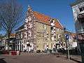
 Harlingen, town hall
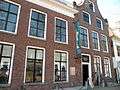 Museum Het Hannemahuis
 Harlingen, monumental building
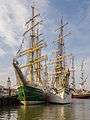 Harlingen Harbour during the Tall Ship races in 2014
References
- ↑ "Het College van B&W" [The board of mayor and aldermen] (in Dutch). Gemeente Harlingen. Archived from the original on 30 August 2013. Retrieved 10 September 2013.
- ↑ "Kerncijfers wijken en buurten" [Key figures for neighbourhoods]. CBS Statline (in Dutch). CBS. 2 July 2013. Retrieved 12 March 2014.
- ↑ "Postcodetool for 8861BD". Actueel Hoogtebestand Nederland (in Dutch). Het Waterschapshuis. Retrieved 10 September 2013.
- ↑ "Bevolkingsontwikkeling; regio per maand" [Population growth; regions per month]. CBS Statline (in Dutch). CBS. 27 October 2017. Retrieved 27 October 2017.
External links
| Wikimedia Commons has media related to Harlingen. |

- Official website (English)
- streaming webcams (Dutch)

Places adjacent to Harlingen, Netherlands | ||||||||||
|---|---|---|---|---|---|---|---|---|---|---|
| ||||||||||
Municipalities of Friesland | ||
|---|---|---|
 | ||
| ||
See also: Elfstedentocht | ||
| Authority control |
|---|