Andrewville, Delaware
| Andrewville | |
|---|---|
| Unincorporated community | |
 | |
 Andrewville Location within the state of Delaware  Andrewville Andrewville (the US) | |
| Coordinates: 38°51′41″N 75°38′06″W / 38.86139°N 75.63500°WCoordinates: 38°51′41″N 75°38′06″W / 38.86139°N 75.63500°W | |
| Country | United States |
| State | Delaware |
| County | Kent |
| Time zone | UTC-5 (Eastern (EST)) |
| • Summer (DST) | UTC-4 (EDT) |
| GNIS feature ID | 216017[1] |
Andrewville is an unincorporated community in Kent County, Delaware.[1] Its elevation is 56 ft (17m) and is located at 38°51′41″N 75°38′06″W / 38.86139°N 75.63500°W. It is located west of Farmington on Andrewville Road.
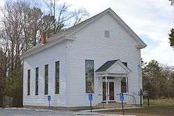
The Bethel Methodist Protestant Church was added to the National Register of Historic Places in 1998.[2]
References
- 1 2 "Andrewville, Delaware". Geographic Names Information System. United States Geological Survey.
- ↑ National Park Service (2009-03-13). "National Register Information System". National Register of Historic Places. National Park Service.
Municipalities and communities of Kent County, Delaware, United States | ||
|---|---|---|
| Cities | ||
| Towns | ||
| CDPs | ||
| Unincorporated communities |
| |
| Hundreds | ||
| Footnotes | ‡This populated place also has portions in an adjacent county or counties | |
This article is issued from
Wikipedia.
The text is licensed under Creative Commons - Attribution - Sharealike.
Additional terms may apply for the media files.